Country:
 Japan
JapanRegion:
City:
Latitude and Longitude:
Time Zone:
Postal Code:
IP information under different IP Channel
ip-api
Country
Region
City
ASN
Time Zone
ISP
Blacklist
Proxy
Latitude
Longitude
Postal
Route
IPinfo
Country
Region
City
ASN
Time Zone
ISP
Blacklist
Proxy
Latitude
Longitude
Postal
Route
MaxMind
Country
Region
City
ASN
Time Zone
ISP
Blacklist
Proxy
Latitude
Longitude
Postal
Route
Luminati
Country
JPRegion
40
City
tonoharu
ASN
Time Zone
Asia/Tokyo
ISP
Research Organization of Information and Systems, National Institute of Informatics
Latitude
Longitude
Postal
db-ip
Country
Region
City
ASN
Time Zone
ISP
Blacklist
Proxy
Latitude
Longitude
Postal
Route
ipdata
Country
Region
City
ASN
Time Zone
ISP
Blacklist
Proxy
Latitude
Longitude
Postal
Route
Popular places and events near this IP address

Fukuoka Dental College
Distance: Approx. 6066 meters
Latitude and longitude: 33.54444444,130.3325
Fukuoka Dental College (福岡歯科大学, Fukuoka shika daigaku) is a private university in Fukuoka, Fukuoka, Japan, established in 1973.
Fukuoka College of Health Sciences
Private junior college in Fukuoka, Fukuoka, Japan
Distance: Approx. 6416 meters
Latitude and longitude: 33.54777778,130.33027778
Fukuoka College of Health Sciences (福岡医療短期大学, Fukuoka iryō tanki daigaku) is a private junior college in Fukuoka, Fukuoka, Japan, established in 1997.

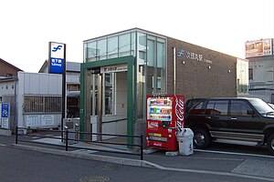
Fukudaimae Station
Metro station in Fukuoka, Japan
Distance: Approx. 7215 meters
Latitude and longitude: 33.5473,130.3621
Fukudaimae Station (福大前駅) is a subway station on the Fukuoka City Subway Nanakuma Line in Jōnan-ku, Fukuoka in Japan. Its station symbol is a picture of a black kite in blue, the symbol of the Fukuoka University.

Umebayashi Station
Metro station in Fukuoka, Japan
Distance: Approx. 6776 meters
Latitude and longitude: 33.54583333,130.355
Umebayashi Station (梅林駅) is a subway station on the Fukuoka City Subway Nanakuma Line in Jōnan-ku, Fukuoka in Japan. Its station symbol is a picture of a plum blossom in pink.

Kamo Station (Fukuoka)
Metro station in Fukuoka, Japan
Distance: Approx. 6803 meters
Latitude and longitude: 33.5505,130.3377
Kamo Station (賀茂駅) is a subway station on the Fukuoka City Subway Nanakuma Line in Sawara-ku, Fukuoka in Japan. Its station symbol is a catfish in violet, the sign of the Kamo Shrine.
Jirōmaru Station
Metro station in Fukuoka, Japan
Distance: Approx. 6937 meters
Latitude and longitude: 33.5525,130.3297
Jirōmaru Station (次郎丸駅) is a subway station on the Fukuoka City Subway Nanakuma Line in Sawara-ku, Fukuoka in Japan. Its station symbol is a firefly in blue, representing the nearby Muromi river.

Noke Station
Metro station in Fukuoka, Japan
Distance: Approx. 6785 meters
Latitude and longitude: 33.5484,130.3472
Noke Station (野芥駅) is a subway station on the Fukuoka City Subway Nanakuma Line in Sawara-ku, Fukuoka in Japan. Its station symbol is a picture of Camellia flowers in red, floating in the Tsubaki channel.

Sefuri Raizan Prefectural Natural Park
Distance: Approx. 7235 meters
Latitude and longitude: 33.43638889,130.36861111
Sefuri Raizan Prefectural Natural Park (脊振雷山県立自然公園, Sefuri Raizan kenritsu shizen kōen) is a Prefectural Natural Park in Fukuoka Prefecture, Japan. Established in 1965, the park spans the municipalities of Fukuoka, Itoshima, and Nakagawa.

Mount Abura
Mountain in the country of Japan
Distance: Approx. 4385 meters
Latitude and longitude: 33.512028,130.3645
Mount Abura (油山, Abura-yama) is a 597 m (1,959 ft) mountain located on the border of Minami-ku, Fukuoka, Sawara-ku, Fukuoka and Jonan-ku, Fukuoka, Fukuoka Prefecture, Japan. Mount Abura is the location where the Indian Buddhist priest Seiga produced the first camellia oil from seeds made in Japan during the Nara period. Abura means oil in Japanese.
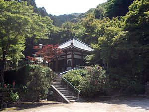
Shōkaku-ji (Fukuoka)
Distance: Approx. 5856 meters
Latitude and longitude: 33.52730556,130.36994444
Shōkaku-ji (正覚寺) is a Rinzai temple in Jōnan-ku, Fukuoka, Japan. Its honorary sangō prefix is Higashiaburayama (東油山). It is also known as Aburayama Kannon (油山観音).
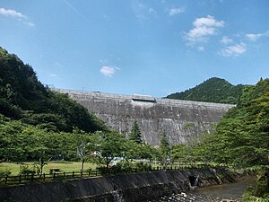
Magaribuchi Dam
Dam in Fukuoka Prefecture, Japan
Distance: Approx. 1811 meters
Latitude and longitude: 33.49777778,130.30777778
Magaribuchi Dam is a gravity dam located in Fukuoka Prefecture in Japan. The dam is used for water supply. The catchment area of the dam is 11.4 km2.

Yoshitaketakagi Site
Distance: Approx. 5338 meters
Latitude and longitude: 33.53794444,130.31855556
Yoshitake Takagi Site (吉武高木遺跡, Yoshitake Takagi iseki) is an archeological site with a Yayoi period cemetery located in Nishi-ku, Fukuoka, Japan. It was designated as a National Historic Site in 1993, with the area under protection expanded in 2000. The designated area including the additional designated area is 42,145.17 square meters, which is approximately one-tenth of the area of the entire ruins group.
Weather in this IP's area
broken clouds
23 Celsius
24 Celsius
23 Celsius
24 Celsius
1020 hPa
83 %
1020 hPa
1005 hPa
10000 meters
5.14 m/s
10 degree
75 %
06:23:51
17:44:20