Country:
Region:
City:
Latitude and Longitude:
Time Zone:
Postal Code:
IP information under different IP Channel
ip-api
Country
Region
City
ASN
Time Zone
ISP
Blacklist
Proxy
Latitude
Longitude
Postal
Route
Luminati
Country
ASN
Time Zone
America/Lima
ISP
ENTEL PERU S.A.
Latitude
Longitude
Postal
IPinfo
Country
Region
City
ASN
Time Zone
ISP
Blacklist
Proxy
Latitude
Longitude
Postal
Route
db-ip
Country
Region
City
ASN
Time Zone
ISP
Blacklist
Proxy
Latitude
Longitude
Postal
Route
ipdata
Country
Region
City
ASN
Time Zone
ISP
Blacklist
Proxy
Latitude
Longitude
Postal
Route
Popular places and events near this IP address
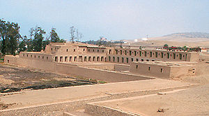
Pachacamac
Archaeological site in Peru
Distance: Approx. 1830 meters
Latitude and longitude: -12.25666667,-76.90027778
Pachacámac (Quechua: Pachakamaq) is an archaeological site 40 kilometres (25 mi) southeast of Lima, Peru in the Valley of the Lurín River. The site was first settled around A.D. 200 and was named after the "Earth Maker" creator god Pacha Kamaq. The site flourished for about 1,300 years until the Spanish invaded.
Lurín District
District in Lima, Peru
Distance: Approx. 2267 meters
Latitude and longitude: -12.27916667,-76.875
Lurín is a district of the Lima Province in Peru. Known for its archaeological temple of Pachacámac, the Pachacámac Islands (or "La Ballena"), countryside areas, villages, fincas, rural restaurants, nightlife and beaches, it is one of the three valleys of the city of Lima.

Pachacámac District
District in Lima, Peru
Distance: Approx. 4365 meters
Latitude and longitude: -12.23,-76.85916667
Pachacámac is one of 43 districts of the Lima Province in Peru. The capital of the district is the village of Pachacámac. Its main asset is the archaeological Inca site Pachacámac.
Roman Catholic Diocese of Lurín
Roman Catholic diocese in Peru
Distance: Approx. 1956 meters
Latitude and longitude: -12.27833333,-76.88277778
The Roman Catholic Diocese of Lurín (Latin: Lurinen(sis)) is a diocese located in the Lurín District in the ecclesiastical province of Lima in Peru.

Lurín River
River in Peru
Distance: Approx. 2654 meters
Latitude and longitude: -12.275,-76.9036
The Lurín River is a 108.57 kilometres (67.46 mi) long watercourse located in the Lima Region of Peru. It originates in the glaciers and lagoons of the western Andes. It is known as the Chalilla River until joining the Taquía creek where it receives its common name.

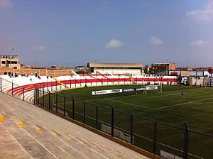
Estadio Iván Elías Moreno
Distance: Approx. 7156 meters
Latitude and longitude: -12.22010556,-76.934925
Estadio Iván Elías Moreno is a multi-purpose stadium in the Villa El Salvador District, Lima, Peru. It is currently used by football team Club Deportivo Municipal. The stadium holds 10,000 people.

2020 Villa El Salvador explosion
2020 explosion in Peru
Distance: Approx. 9369 meters
Latitude and longitude: -12.20819444,-76.95122222
On January 23, 2020, a gas leak from a truck transporting liquefied petroleum gas caused an explosion in Villa El Salvador, Lima metropolitan area, Peru. The subsequent fires affected at least 20 homes and several vehicles.

Villa El Salvador metro station
Lima metro station
Distance: Approx. 4437 meters
Latitude and longitude: -12.23388889,-76.91408333
Villa El Salvador is a Lima and Callao Metro station that serves as the southern terminus of Line 1. The adjacent station is Parque Industrial. The station was inaugurated on 28 April 1990 as part of the first section of the line between Villa El Salvador and Atocongo.

Parque Industrial metro station
Lima metro station
Distance: Approx. 9417 meters
Latitude and longitude: -12.19627778,-76.93997222
Parque Industrial is a Lima and Callao Metro station on Line 1. The station is located between Villa El Salvador and Pumacahua. It was inaugurated on 28 April 1990 as part of the first section of the line between Villa El Salvador and Atocongo.

National Museum of Peru
National museum in Lima, Peru
Distance: Approx. 2986 meters
Latitude and longitude: -12.25425407,-76.91061959
The National Museum of Peru is a national museum in Lurín District, Lima, Peru, located within the archaeological zone of Pachacamac. The museum will hold over a half million artifacts of the Pre-Columbian era and Inca Empire, ranging back to 5,000 BCE. It opened in July 2021 as part of Peru's bicentennial celebrations and is capable of accepting 15,000 guests per day.

Pachacámac Islands
Islands in Peru
Distance: Approx. 5386 meters
Latitude and longitude: -12.30694444,-76.89888889
The Pachacámac Islands (Spanish: Islas Pachacámac), also known as Cavillaca Islands (Spanish: Islas Cavillaca) or as Whale Islands (Spanish: Isla Ballena), are a group of islands located in the Pacific Ocean, off the coast of Lurín District, in Lima Province, Peru. Its formed by two main islands (the 23,6 ha Pachacámac Island and the 7,05 ha Peñón Pachacámac) and three islets. They are located about 3 kilometres (1.9 mi) south of the mouth of the Lurín River and about 31 31 kilometres (19 mi) from the city of Lima.
Weather in this IP's area
scattered clouds
20 Celsius
20 Celsius
19 Celsius
20 Celsius
1015 hPa
88 %
1015 hPa
1013 hPa
10000 meters
2.45 m/s
2.93 m/s
162 degree
49 %
05:32:00
18:12:20