Country:
Region:
City:
Latitude and Longitude:
Time Zone:
Postal Code:
IP information under different IP Channel
ip-api
Country
Region
City
ASN
Time Zone
ISP
Blacklist
Proxy
Latitude
Longitude
Postal
Route
Luminati
Country
ASN
Time Zone
America/Chicago
ISP
NOAA-BOULDER
Latitude
Longitude
Postal
IPinfo
Country
Region
City
ASN
Time Zone
ISP
Blacklist
Proxy
Latitude
Longitude
Postal
Route
db-ip
Country
Region
City
ASN
Time Zone
ISP
Blacklist
Proxy
Latitude
Longitude
Postal
Route
ipdata
Country
Region
City
ASN
Time Zone
ISP
Blacklist
Proxy
Latitude
Longitude
Postal
Route
Popular places and events near this IP address

Montgomery County, Maryland
County in Maryland, United States
Distance: Approx. 1303 meters
Latitude and longitude: 39.13638,-77.20424
Montgomery County is the most populous county in the U.S. state of Maryland. As of the 2020 census, the county's population was 1,062,061, increasing by 9.3% from 2010. The county seat is Rockville, and Germantown is the most populous place in the county.

Gaithersburg, Maryland
City in Maryland, United States
Distance: Approx. 1144 meters
Latitude and longitude: 39.13194444,-77.22638889
Gaithersburg ( GAY-thərz-burg) is a city in Montgomery County, Maryland, United States. At the time of the 2020 census, Gaithersburg had a population of 69,657, making it the ninth-most populous community in the state. Gaithersburg is located to the northwest of Washington, D.C., and is considered a suburb and a primary city within the Washington metropolitan area.

Gaithersburg Latitude Observatory
Historic district in Maryland, United States
Distance: Approx. 1715 meters
Latitude and longitude: 39.13666667,-77.19916667
The Gaithersburg Latitude Observatory is a historic astronomical observatory on DeSellum Avenue in Gaithersburg, Maryland. It was established in 1899 as part of a system of six International Latitude Observatories to precisely measure the wobble of the Earth's rotating axis. The observatory building and adjacent monuments were designated a National Historic Landmark in 1989 as a testament to international scientific cooperation.

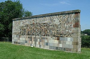
NIST stone test wall
Distance: Approx. 1985 meters
Latitude and longitude: 39.12245,-77.22075
The NIST stone test wall is an experiment by the United States National Institute of Standards and Technology to determine how different types of construction stone weather. It includes 2352 samples of stone from 47 US states and 16 countries. The wall measures approximately 12 m long, 4 m high, 0.6 m thick at the bottom, and 0.3 m at the top.

Lakeforest Mall
Abandoned shopping mall in Maryland, U.S.
Distance: Approx. 1929 meters
Latitude and longitude: 39.153524,-77.204221
Lakeforest Mall, formally the Lakeforest Regional Mall, also known as Lakeforest, is an abandoned enclosed shopping mall located in Gaithersburg, Maryland. The property is currently owned by WRS Inc. Real Estate Investments who is planning to redevelop the site.
GlobalStem
Company in Rockville, Maryland, US
Distance: Approx. 745 meters
Latitude and longitude: 39.1414,-77.210007
GlobalStem, Inc. is a biotechnology company based in Rockville, Maryland. GlobalStem is a provider of laboratory products and services for the stem cell research community.

Gaithersburg High School
Public secondary school in Gaithersburg, Maryland, United States
Distance: Approx. 2122 meters
Latitude and longitude: 39.13547778,-77.19469444
Gaithersburg High School (GHS) is a public high school located in Gaithersburg, Maryland. Part of Montgomery County Public Schools, the school is located at 101 Education Boulevard and consists of grades 9–12. Its feeder schools are Forest Oak Middle School and Gaithersburg Middle School.

Gaithersburg station
MARC rail station in Gaithersburg, Maryland, United States
Distance: Approx. 2202 meters
Latitude and longitude: 39.14152778,-77.19305556
Gaithersburg station is a commuter rail station located on the Metropolitan Subdivision in downtown Gaithersburg, Maryland. It is served by the MARC Brunswick Line service; it was also served by Amtrak from 1971 to 1986. The former Baltimore and Ohio Railroad station building and freight shed, designed by Ephraim Francis Baldwin and built in 1884, are listed on the National Register of Historic Places as Gaithersburg B & O Railroad Station and Freight Shed.

Metropolitan Grove station
Rail station in Gaithersburg, Maryland, United States
Distance: Approx. 1281 meters
Latitude and longitude: 39.14972222,-77.22683333
Metropolitan Grove is a passenger rail station on the MARC Brunswick Line between Washington, D.C. and Martinsburg, WV (with an extension to Frederick, MD). Metropolitan Grove Station is nearest Browns Station Park. The large Watkins Mill Town Center development is adjacent and still under construction.

J. A. Belt Building
United States historic place
Distance: Approx. 2113 meters
Latitude and longitude: 39.14222222,-77.19416667
The John A. Belt Building is a historic commercial building located at 227 East Diamond Avenue in Gaithersburg, Montgomery County, Maryland.
Thomas and Company Cannery
United States historic place
Distance: Approx. 1455 meters
Latitude and longitude: 39.14201583,-77.201813
The Thomas and Company Cannery is a historic building located at Gaithersburg, Montgomery County, Maryland. It is a one to two-story tall, free-standing, load-bearing brick rectangular structure composed of four discrete, structurally independent but contiguous elements, built between 1917 and 1918. An addition was constructed in 1956.

Novavax
American biotechnology company
Distance: Approx. 788 meters
Latitude and longitude: 39.1371,-77.2267
Novavax, Inc. is an American biotechnology company based in Gaithersburg, Maryland, that develops vaccines to counter serious infectious diseases. Prior to 2020, company scientists developed experimental vaccines for influenza and respiratory syncytial virus (RSV), as well as Ebola and other emerging infectious diseases.
Weather in this IP's area
clear sky
11 Celsius
10 Celsius
10 Celsius
13 Celsius
1018 hPa
64 %
1018 hPa
1002 hPa
10000 meters
2.06 m/s
320 degree
06:53:52
16:53:53
