Country:
Region:
City:
Latitude and Longitude:
Time Zone:
Postal Code:
IP information under different IP Channel
ip-api
Country
Region
City
ASN
Time Zone
ISP
Blacklist
Proxy
Latitude
Longitude
Postal
Route
Luminati
Country
Region
lma
City
lima
ASN
Time Zone
America/Lima
ISP
ENTEL PERU S.A.
Latitude
Longitude
Postal
IPinfo
Country
Region
City
ASN
Time Zone
ISP
Blacklist
Proxy
Latitude
Longitude
Postal
Route
db-ip
Country
Region
City
ASN
Time Zone
ISP
Blacklist
Proxy
Latitude
Longitude
Postal
Route
ipdata
Country
Region
City
ASN
Time Zone
ISP
Blacklist
Proxy
Latitude
Longitude
Postal
Route
Popular places and events near this IP address
Huachis District
District in Ancash, Peru
Distance: Approx. 2991 meters
Latitude and longitude: -9.40277778,-77.12666667
Huachis District is one of sixteen districts of the Huari Province in the Ancash Region in Peru.

Rahuapampa District
District in Ancash, Peru
Distance: Approx. 6213 meters
Latitude and longitude: -9.38305556,-77.15
Rahuapampa District is one of sixteen districts of the Huari Province in Peru.
San Pedro de Chana District
District in Ancash, Peru
Distance: Approx. 7966 meters
Latitude and longitude: -9.39416,-77.02964
San Pedro de Chana District is one of sixteen districts of the Huari Province in Peru.

Markahirka
Archaeological site in Peru
Distance: Approx. 5428 meters
Latitude and longitude: -9.37073611,-77.12986111
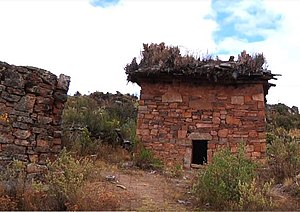
Markahirka or Marka Hirka (Quechua marka village, Ancash Quechua hirka mountain, "village mountain", Hispanicized spellings Marca Jirca, Marcajirca) is an archaeological site with cave paintings and stone tombs (chullpa) on a mountain of the same name in Peru. It is located in the Ancash Region, Huari Province, in the districts of Cajay and Masin. It is situated at a height of 3,580 metres (11,745 ft).
Jatunjirca (Huari)
Mountain in Peru
Distance: Approx. 9569 meters
Latitude and longitude: -9.38111111,-77.1825
Jatunjirca (possibly from Quechua hatun big, Ancash Quechua hirka mountain) is a mountain in the eastern part of the Cordillera Blanca in the Andes of Peru which reaches a height of approximately 3,800 m (12,500 ft). It is located in the Ancash Region, Huari Province, Huari District, southwest of Huari and west of the village of Yacya.
Weather in this IP's area
overcast clouds
9 Celsius
9 Celsius
9 Celsius
9 Celsius
1018 hPa
85 %
1018 hPa
684 hPa
10000 meters
0.89 m/s
1.27 m/s
228 degree
100 %
05:36:50
18:09:13