Country:
Region:
City:
Latitude and Longitude:
Time Zone:
Postal Code:
IP information under different IP Channel
ip-api
Country
Region
City
ASN
Time Zone
ISP
Blacklist
Proxy
Latitude
Longitude
Postal
Route
Luminati
Country
Region
lma
City
lima
ASN
Time Zone
America/Lima
ISP
ENTEL PERU S.A.
Latitude
Longitude
Postal
IPinfo
Country
Region
City
ASN
Time Zone
ISP
Blacklist
Proxy
Latitude
Longitude
Postal
Route
db-ip
Country
Region
City
ASN
Time Zone
ISP
Blacklist
Proxy
Latitude
Longitude
Postal
Route
ipdata
Country
Region
City
ASN
Time Zone
ISP
Blacklist
Proxy
Latitude
Longitude
Postal
Route
Popular places and events near this IP address

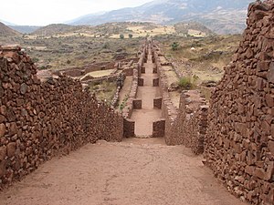
Pikillaqta
Archaeological site in Peru
Distance: Approx. 6733 meters
Latitude and longitude: -13.61666667,-71.71472222
Pikillaqta (Quechua piki flea, llaqta a place (village, town, community, country, nation), "flea place", also spelled Piki Llacta, Pikillacta, Piquillacta, Piquillaqta) is a large Wari culture archaeological site 20 kilometres (12 mi) east of Cusco in the Quispicanchi Province. Pikillaqta is a village of the Wari people. Wari was the centre village and other cities like Pikillaqta were influenced by it.

Lucre District, Quispicanchi
District in Cusco, Peru
Distance: Approx. 6115 meters
Latitude and longitude: -13.6386,-71.7407
The Lucre District is one of the twelve districts in the Quispicanchi Province in Peru. Created by Law No. 9295 on January 17, 1941, its capital is the town of Lucre.

Oropesa District, Quispicanchi
District in Cusco, Peru
Distance: Approx. 809 meters
Latitude and longitude: -13.5964,-71.7654
The Oropesa District is one of the twelve districts in the Quispicanchi Province in Peru. Its capital is the town of Oropesa.
Saylla District
District in Cusco, Peru
Distance: Approx. 7857 meters
Latitude and longitude: -13.5649,-71.8386
Saylla District is one of eight districts of the province Cusco in Peru.
Caicay District
District in Cusco, Peru
Distance: Approx. 8147 meters
Latitude and longitude: -13.5981,-71.6968
Caicay District is one of six districts of the province Paucartambo in Peru.

Tipón
Archaeological park in Peru near Cusco with an Incan monumental hydraulic system
Distance: Approx. 2727 meters
Latitude and longitude: -13.57083333,-71.78305556
Tipón is a sprawling early fifteenth-century Inca archaeological site that is situated between 3,250 metres (10,660 ft) and 3,960 metres (12,990 ft) above sea level, located 22 kilometres (14 mi) southeast of Cusco near the village of Tipón. It consists of several ruins enclosed by a powerful defensive wall about 6 kilometres (3.7 mi) long. The most renown (and easily accessible) part of the park is the group of precise and right angled monumental terraces irrigated by a network of water canals fed by a monumental fountain channeling water from a natural spring.

Rumicolca
Archaeological site in Peru
Distance: Approx. 7542 meters
Latitude and longitude: -13.61805556,-71.70722222
Rumicolca (possibly from Quechua rumi stone, qullqa, qulqa deposit, storehouse) is an archaeological site in Peru. It is located in the Cusco Region, Quispicanchi Province, Lucre District. Rumicolca is situated near the archaeological sites Chuqi Pukyu and Pikillaqta, east of Lake Huacarpay.

Pachatusan
Archaeological site in Peru
Distance: Approx. 8219 meters
Latitude and longitude: -13.51944444,-71.78055556
Pachatusan (Quechua pacha earth, tusa, a prop to support a wall or building, pachatusa prop of the earth, -n a suffix) is a mountain northeast of the city of Cusco in the Andes of Peru, about 4,842 metres (15,886 ft) high. It is located in the Cusco Region, Calca Province, San Salvador District, in the Cusco Province, in the districts San Jerónimo and Saylla, and in the Quispicanchi Province, Oropesa District. It is situated on the western bank of the Vilcanota River, beside the mountain Huaypun in the south-east.

Tauja
Mountain in Peru
Distance: Approx. 8529 meters
Latitude and longitude: -13.53444444,-71.72083333
Tauja (possibly from Quechua for heap, pile,) is a 4,039.8-metre-high (13,254 ft) mountain in the Cusco Region in Peru. It is situated in the Calca Province, San Salvador District, and in the Paucartambo Province, Caicay District, northeast of Huaypun. The Vilcanota River flows around its southern and western slopes.

Huaypun
Mountain in Peru
Distance: Approx. 5072 meters
Latitude and longitude: -13.54833333,-71.76166667
Huaypun (possibly from Quechua waypu a name applied for different species of Tinamidae, Nothoprocta pentlandii, Rhynchotus rufescens and Rhynchotus maculicollis, -n a suffix) is a mountain in the Cusco Region in Peru, about 4,200 metres (13,780 ft) high. It is situated in the Calca Province, San Salvador District, and in the Quispicanchi Province, Oropesa District. Huaypun lies on the western bank of the Vilcanota River, southeast of Pachatusan and southwest of Tauja.

Qusqu Qhawarina (Quispicanchi)
Mountain in Peru
Distance: Approx. 9881 meters
Latitude and longitude: -13.66638889,-71.72083333
Qusqu Qhawarina (Quechua qusqu boundary stone; nucleus; navel; heap of earth and stones; bed, dry bed of a lake, Qusqu Cusco (a city), qhawarina, qhawana viewpoint, here translated to "boundary stone viewpoint", Hispanicized spelling Cusco Jahuarina) is a 4,145-metre-high (13,599 ft) mountain in the Cusco Region in Peru. It is situated in the Quispicanchi Province, on the border of the districts of Andahuaylillas and Lucre. Qusqu Qhawarina lies on the left bank of the Willkanuta River, northeast of a mountain named Saywa (Quechua for boundary stone, landmark).
Weather in this IP's area
overcast clouds
11 Celsius
11 Celsius
11 Celsius
11 Celsius
1015 hPa
93 %
1015 hPa
707 hPa
10000 meters
2.57 m/s
100 %
05:09:39
17:53:46