Country:
 Singapore
Region:
City:
Latitude and Longitude:
Time Zone:
Postal Code:
IP information under different IP Channel
ip-api
Country
Region
City
ASN
Time Zone
ISP
Blacklist
Proxy
Latitude
Longitude
Postal
Route
IPinfo
Country
Region
City
ASN
Time Zone
ISP
Blacklist
Proxy
Latitude
Longitude
Postal
Route
MaxMind
Country
Region
City
ASN
Time Zone
ISP
Blacklist
Proxy
Latitude
Longitude
Postal
Route
Luminati
Country
SGCity
singapore
ASN
Time Zone
Asia/Singapore
ISP
Viewqwest Pte Ltd
Latitude
Longitude
Postal
db-ip
Country
Region
City
ASN
Time Zone
ISP
Blacklist
Proxy
Latitude
Longitude
Postal
Route
ipdata
Country
Region
City
ASN
Time Zone
ISP
Blacklist
Proxy
Latitude
Longitude
Postal
Route
Popular places and events near this IP address

Kallang
Planning Area and HDB Town in Central Region ----, Singapore
Distance: Approx. 567 meters
Latitude and longitude: 1.31083333,103.86555556
Kallang is a planning area and residential zone located in the Central Region of Singapore. Development of the town is centered around the Kallang River, the longest river in Singapore. Kallang Planning Area is bounded by Toa Payoh in the north, Geylang in the east, Marine Parade in the southeast, Marina East in the south, the Downtown Core in the southwest, Rochor, Newton in the west, and Novena in the northwest.

Boon Keng MRT station
Mass Rapid Transit station in Singapore
Distance: Approx. 558 meters
Latitude and longitude: 1.319483,103.861722
Boon Keng MRT station is an underground Mass Rapid Transit (MRT) station on the North East line in Kallang, Singapore. Located underneath Serangoon Road just after the traffic junction with Towner Road and Boon Keng Road, Boon Keng station primarily serves the Boon Keng subzone and more importantly the residents residing in the area. Other than the HDB dwellers, residents of condos such as Eight Riversuites, Regent Residences and The Arcady at Boon Keng also benefited greatly from the convenience.

CNA938
Radio station
Distance: Approx. 192 meters
Latitude and longitude: 1.312751,103.862
CNA938 is an English-language radio station in Singapore. Owned by the state-owned broadcaster Mediacorp and launched on 2 October 1998, it broadcasts a news/talk radio format. The station is marketed as a radio extension of Mediacorp's television channel CNA, broadcasting news and lifestyle programmes from 7 a.m.
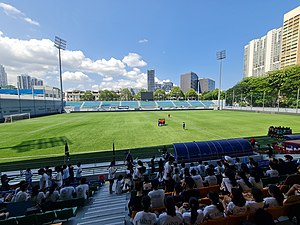
Jalan Besar Stadium
Stadium in Singapore
Distance: Approx. 530 meters
Latitude and longitude: 1.310016,103.860347
Jalan Besar Stadium, officially the Jalan Besar ActiveSG Stadium, is a football stadium located in Kallang, Singapore. The stadium is part of the Jalan Besar Sports and Recreation Centre, a community sports facility that includes the stadium as well as a swimming complex. It is the home ground of the Singapore Premier League club Young Lions.
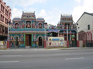
Sri Vadapathira Kaliamman Temple
Hindu temple in Singapore
Distance: Approx. 458 meters
Latitude and longitude: 1.31543056,103.858
The Sri Vadapathira Kaliamman Temple is a Hindu temple located in Little India in Singapore.

Central Sikh Temple
Gurdwara in Singapore
Distance: Approx. 437 meters
Latitude and longitude: 1.3166,103.8587
Central Sikh Temple is the first Sikh gurdwara in Singapore. Established in 1912, the temple had relocated several times before moving to its current site at Towner Road at the junction of Serangoon Road in Kallang in 1986 near Boon Keng MRT station.
Bendemeer MRT station
Mass Rapid Transit station in Singapore
Distance: Approx. 152 meters
Latitude and longitude: 1.3135953,103.8630402
Bendemeer MRT station is an underground Mass Rapid Transit (MRT) station on the Downtown line in Kallang, Singapore. Despite its name, the station is not located under Bendemeer Road, but under Kallang Bahru. This station serves the commercial developments around Lavender Street and the industrial estates along Kallang Avenue.
Kallang Bahru
Subzone of Kallang Planning Area in Central Region, Singapore
Distance: Approx. 465 meters
Latitude and longitude: 1.3179,103.8644
Kallang Bahru is a subzone within the planning area of Kallang, Singapore, as defined by the Urban Redevelopment Authority (URA). This subzone is bounded by Bendemeer Road and Sungei Whampoa in the north; the Kallang River in the east; Kallang Road and Sims Avenue in the south; and Lavender Street in the west. "Kallang Bahru" is also the name of a two-way road in the area.

National Football Academy (Singapore)
Distance: Approx. 530 meters
Latitude and longitude: 1.310016,103.860347
The National Football Academy, commonly referred to as NFA, is a football academy based in Jalan Besar, Singapore. It was launched by the Football Association of Singapore on 13 August 2000 with the aim of developing Singapore's most promising young footballers. Trainees are scouted through a systematic talent identification process before being given the chance to develop their skills under some of the best youth coaches in the country.

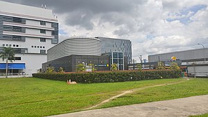
HackerspaceSG
Singaporean organisation
Distance: Approx. 490 meters
Latitude and longitude: 1.31008796,103.86229645
HackerspaceSG is a 1,202-square-foot (111.7 m2) technology community center and hackerspace in Singapore. While predominantly an open working space for software projects, HackerspaceSG is also a landmark of the Singapore DIY movement, and also hosts a range of events from technology classes to biology, computer hardware, and manufacturing. The space is open to all types of hackers.
593 Serangoon Road
Distance: Approx. 424 meters
Latitude and longitude: 1.31607,103.85854
593 Serangoon Road is a shophouse on the corner of Serangoon Road and Balestier Road. It previously housed the Singapore Institute of Science and currently houses the Sin Peng Lounge.
161 Lavender Street
Shophouses in Kallang, Singapore
Distance: Approx. 216 meters
Latitude and longitude: 1.31287,103.86092
161 Lavender Street is a row of shophouses on Lavender Street in the Lavender subzone of Kallang, Singapore. Completed by philanthropist Lee Kong Chian in the 1930s, it was gazetted for conservation as part of the Jalan Besar Secondary Settlement conservation area.
Weather in this IP's area
scattered clouds
32 Celsius
38 Celsius
30 Celsius
32 Celsius
1012 hPa
66 %
1012 hPa
1010 hPa
10000 meters
2.57 m/s
80 degree
40 %
06:46:54
18:51:47