Country:
 USA
USARegion:
City:
Latitude and Longitude:
Time Zone:
Postal Code:
IP information under different IP Channel
ip-api
Country
Region
City
ASN
Time Zone
ISP
Blacklist
Proxy
Latitude
Longitude
Postal
Route
IPinfo
Country
Region
City
ASN
Time Zone
ISP
Blacklist
Proxy
Latitude
Longitude
Postal
Route
MaxMind
Country
Region
City
ASN
Time Zone
ISP
Blacklist
Proxy
Latitude
Longitude
Postal
Route
Luminati
Country
USRegion
mo
City
wyaconda
ASN
Time Zone
America/Chicago
ISP
MARK-TWAIN
Latitude
Longitude
Postal
db-ip
Country
Region
City
ASN
Time Zone
ISP
Blacklist
Proxy
Latitude
Longitude
Postal
Route
ipdata
Country
Region
City
ASN
Time Zone
ISP
Blacklist
Proxy
Latitude
Longitude
Postal
Route
Popular places and events near this IP address
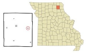
Knox City, Missouri
City in Missouri, United States
Distance: Approx. 842 meters
Latitude and longitude: 40.14472222,-92.01055556
Knox City is a city in eastern Knox County, Missouri, United States. As of the 2020 census, its population was 191.

Ravensborg
Distance: Approx. 5640 meters
Latitude and longitude: 40.16993889,-91.96101389
Ravensborg, originally called Norstead, was the name of a replica Viking Age fort in northern Missouri, near Knox City. Initial construction of the fort began in the spring of 2007. The site was renamed "Ravensborg" in 2009.
Bee Ridge (Missouri)
Ridge in the American state of Missouri
Distance: Approx. 8011 meters
Latitude and longitude: 40.0753179,-92.0596213
Bee Ridge is a ridge in Knox County in the U.S. state of Missouri. Bee Ridge was named for the honeybees in the area.
Bridge Creek (Fabius River tributary)
Stream in the American state of Missouri
Distance: Approx. 8717 meters
Latitude and longitude: 40.1975407,-91.946284
Bridge Creek is a stream in Knox and Lewis counties of the U.S. state of Missouri. It is a tributary of the Middle Fabius River. Bridge Creek was named for a covered bridge near its mouth.
Coon Creek (South Fork Fabius River tributary)
Stream in the U.S. state of Missouri
Distance: Approx. 9275 meters
Latitude and longitude: 40.0878175,-92.0993453
Coon Creek is a stream in Knox County in the U.S. state of Missouri. It is a tributary of the South Fork Fabius River. Coon Creek was named for the abundance of raccoons in the area.
Cottey Creek
Stream in the American state of Missouri
Distance: Approx. 4039 meters
Latitude and longitude: 40.1255955,-92.0565659
Cottey Creek (also called Cottey Branch) is a stream in Knox County in the U.S. state of Missouri. It is a tributary of Troublesome Creek. The stream headwaters arise at 40°05′36″N 92°03′29″W and it flows generally north for approximately two miles to its confluence at 40°07′32″N 92°03′24″W. The confluence is 2.5 miles southwest of Knox City and 6.5 miles southeast of Edina.
Forest Springs, Missouri
Unincorporated community in Missouri, United States
Distance: Approx. 7253 meters
Latitude and longitude: 40.18611111,-91.95527778
Forest Springs is an extinct town in Knox County, in the U.S. state of Missouri. The GNIS classifies it as a populated place. Forest Springs had its start in 1882 when a mineral spa opened at the site.
Jeddo, Missouri
Unincorporated community in Missouri, United States
Distance: Approx. 5503 meters
Latitude and longitude: 40.10027778,-91.96861111
Jeddo is an unincorporated community in Knox County, in the U.S. state of Missouri. The first settlement at Jeddo was made in the 1830s. When the railroad bypassed Jeddo in 1872, business activities shifted to other nearby places, and the population dwindled.
Sweet Oak Branch
Stream in the American state of Missouri
Distance: Approx. 8625 meters
Latitude and longitude: 40.074486,-91.952117
Sweet Oak Branch is a stream in Knox County in the U.S. state of Missouri. Sweet Oak Branch was named for the sweet oak timber near its course.
Wolf Branch (Little Bridge Creek tributary)
Stream in the American state of Missouri
Distance: Approx. 4672 meters
Latitude and longitude: 40.178929,-92.005731
Wolf Branch is a stream in Knox County in the U.S. state of Missouri. It is a tributary of Little Bridge Creek. Wolf Branch was named for the wolves seen in the area.
Jeddo Township, Knox County, Missouri
Township in Knox County, Missouri, U.S.
Distance: Approx. 5960 meters
Latitude and longitude: 40.0844,-92
Jeddo Township is an inactive township in Knox County, in the U.S. state of Missouri. Jeddo Township was established in 1859, taking its name from the community of Jeddo, Missouri.
Myrtle Township, Knox County, Missouri
Township in the American state of Missouri
Distance: Approx. 3933 meters
Latitude and longitude: 40.1714,-92
Myrtle Township is an inactive township in Knox County, in the U.S. state of Missouri. Myrtle Township was established in 1872.
Weather in this IP's area
clear sky
4 Celsius
1 Celsius
2 Celsius
5 Celsius
1026 hPa
60 %
1026 hPa
999 hPa
10000 meters
3.62 m/s
8.44 m/s
179 degree
07:22:11
18:23:39