Country:
 USA
USARegion:
City:
Latitude and Longitude:
Time Zone:
Postal Code:
IP information under different IP Channel
ip-api
Country
Region
City
ASN
Time Zone
ISP
Blacklist
Proxy
Latitude
Longitude
Postal
Route
IPinfo
Country
Region
City
ASN
Time Zone
ISP
Blacklist
Proxy
Latitude
Longitude
Postal
Route
MaxMind
Country
Region
City
ASN
Time Zone
ISP
Blacklist
Proxy
Latitude
Longitude
Postal
Route
Luminati
Country
USRegion
mo
City
shelbyville
ASN
Time Zone
America/Chicago
ISP
MARK-TWAIN
Latitude
Longitude
Postal
db-ip
Country
Region
City
ASN
Time Zone
ISP
Blacklist
Proxy
Latitude
Longitude
Postal
Route
ipdata
Country
Region
City
ASN
Time Zone
ISP
Blacklist
Proxy
Latitude
Longitude
Postal
Route
Popular places and events near this IP address

Shelby County, Missouri
County in Missouri, United States
Distance: Approx. 2696 meters
Latitude and longitude: 39.79,-92.07
Shelby County is a county located in the northeastern portion of the U.S. state of Missouri. As of the 2020 census, the population was 6,103. Its county seat is Shelbyville.

Bethel, Missouri
Village in Missouri, United States
Distance: Approx. 7955 meters
Latitude and longitude: 39.87722222,-92.02444444
Bethel is a village in Shelby County, Missouri, United States. The population was 135 at the 2020 census.

Shelbyville, Missouri
City in Missouri, United States
Distance: Approx. 729 meters
Latitude and longitude: 39.80722222,-92.04111111
Shelbyville is a city in Shelby County, Missouri, United States. The population was 518 at the 2020 census. It is the county seat of Shelby County.
Shelby County Airport (Missouri)
Airport in Shelbyville, Missouri
Distance: Approx. 926 meters
Latitude and longitude: 39.81670556,-92.05017222
Shelby County Airport (FAA LID: 6K2) is a public airport located 1 mile (2 km) northwest of Shelbyville, in Shelby County, Missouri, USA.

Bethel Historic District (Bethel, Missouri)
Historic district in Missouri, United States
Distance: Approx. 8100 meters
Latitude and longitude: 39.87833333,-92.02333333
Bethel Historic District is roughly bounded by Liberty, King, 1st, and 4th Sts. in Bethel, Missouri. Construction of the town, which was for over thirty years a successful experiment in communal living, began in 1844.
Kellerville, Missouri
Unincorporated community in the American state of Missouri
Distance: Approx. 7465 meters
Latitude and longitude: 39.82194444,-92.135
Kellerville is an unincorporated community in Shelby County, in the U.S. state of Missouri. Kellerville was founded circa 1906, at the time the railroad was built through the neighborhood. The community bears the name of the local Keller family.
Kirby, Missouri
Unincorporated community in the American state of Missouri
Distance: Approx. 6943 meters
Latitude and longitude: 39.84555556,-92.11472222
Kirby is an unincorporated community in Shelby County, in the U.S. state of Missouri.
Mesner Branch
Stream in Shelby County, Missouri, U.S.
Distance: Approx. 6429 meters
Latitude and longitude: 39.853929,-92.003228
Mesner Branch is a stream in Shelby County in the U.S. state of Missouri. It is a tributary of the North River. A variant spelling was "Messner Branch".
Pollard Branch
Stream in Shelby County, Missouri, U.S.
Distance: Approx. 5364 meters
Latitude and longitude: 39.8355943,-92.1012873
Pollard Branch (also called Pollards Branch) is a stream in Shelby County in the U.S. state of Missouri. Pollard Branch has the name of Elijah Pollard, a pioneer settler.
Walkersville, Missouri
Unincorporated community in the American state of Missouri
Distance: Approx. 7727 meters
Latitude and longitude: 39.74055556,-92.06861111
Walkersville is an unincorporated community in Shelby County, in the U.S. state of Missouri.
Black Creek Township, Shelby County, Missouri
Inactive township in the American state of Missouri
Distance: Approx. 2247 meters
Latitude and longitude: 39.8225,-92.0683
Black Creek Township is an inactive township in Shelby County, in the U.S. state of Missouri. Black Creek Township was erected in the 1834, taking its name from Black Creek.
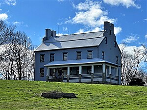
Elim (Bethel, Missouri)
Historic house in Missouri, United States
Distance: Approx. 7882 meters
Latitude and longitude: 39.86944444,-92.00277778
Elim, also known as the Dr. William Keil House, is a historic home located near Bethel, Shelby County, Missouri. It was built in the late-1840s, and is a 2+1⁄2-story, brick and stone dwelling over a full basement.
Weather in this IP's area
clear sky
10 Celsius
9 Celsius
9 Celsius
10 Celsius
1023 hPa
83 %
1023 hPa
996 hPa
10000 meters
0.45 m/s
0.89 m/s
277 degree
06:43:19
19:28:25