Country:
 USA
USARegion:
City:
Latitude and Longitude:
Time Zone:
Postal Code:
IP information under different IP Channel
ip-api
Country
Region
City
ASN
Time Zone
ISP
Blacklist
Proxy
Latitude
Longitude
Postal
Route
IPinfo
Country
Region
City
ASN
Time Zone
ISP
Blacklist
Proxy
Latitude
Longitude
Postal
Route
MaxMind
Country
Region
City
ASN
Time Zone
ISP
Blacklist
Proxy
Latitude
Longitude
Postal
Route
Luminati
Country
USRegion
mo
City
edina
ASN
Time Zone
America/Chicago
ISP
MARK-TWAIN
Latitude
Longitude
Postal
db-ip
Country
Region
City
ASN
Time Zone
ISP
Blacklist
Proxy
Latitude
Longitude
Postal
Route
ipdata
Country
Region
City
ASN
Time Zone
ISP
Blacklist
Proxy
Latitude
Longitude
Postal
Route
Popular places and events near this IP address
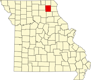
Knox County, Missouri
County in Missouri, United States
Distance: Approx. 6934 meters
Latitude and longitude: 40.12,-92.15
Knox County is a county located in the northeast portion of the U.S. state of Missouri. As of the 2020 census, its population was 3,744, making it the third-least populous county in Missouri. Its county seat is Edina.

Baring, Missouri
City in Missouri, United States
Distance: Approx. 8716 meters
Latitude and longitude: 40.24388889,-92.20666667
Baring is a city in northern Knox County, Missouri, United States. As of the 2020 census, its population is 125. Baring is located on the Burlington Northern and Santa Fe railroad's mainline between Chicago and Los Angeles, which can carry heavy mixed freight and intermodal traffic, as well as Amtrak's Southwest Chief passenger train.
Edina, Missouri
City in Missouri, United States
Distance: Approx. 2918 meters
Latitude and longitude: 40.16888889,-92.17333333
Edina is a city and county seat of Knox County, Missouri, United States, between the North and South Forks of the South Fabius River. As of the 2020 census, its population was 1,012.
Cottey Creek
Stream in the American state of Missouri
Distance: Approx. 9722 meters
Latitude and longitude: 40.1255955,-92.0565659
Cottey Creek (also called Cottey Branch) is a stream in Knox County in the U.S. state of Missouri. It is a tributary of Troublesome Creek. The stream headwaters arise at 40°05′36″N 92°03′29″W and it flows generally north for approximately two miles to its confluence at 40°07′32″N 92°03′24″W. The confluence is 2.5 miles southwest of Knox City and 6.5 miles southeast of Edina.
Democrat Creek
Stream in Missouri, U.S.
Distance: Approx. 5600 meters
Latitude and longitude: 40.1439275,-92.1865714
Democrat Creek is a stream in Knox County in the U.S. state of Missouri. It is a tributary to Rock Creek. The confluence is approximately one mile south-southeast of Edina.
Rock Creek (South Fork South Fabius River tributary)
Stream in the American state of Missouri
Distance: Approx. 4040 meters
Latitude and longitude: 40.152261,-92.170737
Rock Creek is a stream in Knox County in the U.S. state of Missouri. It is a tributary of the South Fork South Fabius River. Rock Creek was named for the character of its creek bed.
Benton Township, Knox County, Missouri
Inactive township in the American state of Missouri
Distance: Approx. 8904 meters
Latitude and longitude: 40.2597,-92.1183
Benton Township is an inactive township in Knox County, in the U.S. state of Missouri. Benton Township has the name of Thomas Hart Benton, a state legislator.
Center Township, Knox County, Missouri
Inactive township in the American state of Missouri
Distance: Approx. 2947 meters
Latitude and longitude: 40.1681,-92.1731
Center Township is an inactive township in Knox County, in the U.S. state of Missouri. Center Township most likely derives its name from "Centerville", an old variant name of Colony, Missouri.
Liberty Township, Knox County, Missouri
Inactive township in the American state of Missouri
Distance: Approx. 2593 meters
Latitude and longitude: 40.1722,-92.1161
Liberty Township is an inactive township in Knox County, in the U.S. state of Missouri. Liberty Township was established in 1872, and named for the American principle of liberty.
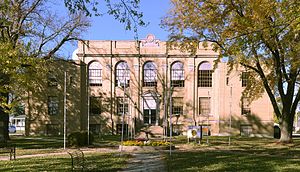
Edina Double Square Historic District
Historic district in Missouri, United States
Distance: Approx. 2994 meters
Latitude and longitude: 40.16694444,-92.17277778
Edina Double Square Historic District is a national historic district located at Edina, Knox County, Missouri. The district encompasses 37 contributing buildings in the central business district of Edina. It developed between about 1865 and 1945 and includes representative examples of Italianate and Streamline Moderne style architecture.
Weather in this IP's area
clear sky
5 Celsius
3 Celsius
4 Celsius
6 Celsius
1027 hPa
58 %
1027 hPa
999 hPa
10000 meters
3.73 m/s
10.04 m/s
175 degree
07:22:46
18:24:08