131.188.40.90 - IP Lookup: Free IP Address Lookup, Postal Code Lookup, IP Location Lookup, IP ASN, Public IP
Country:
Region:
City:
Location:
Time Zone:
Postal Code:
IP information under different IP Channel
ip-api
Country
Region
City
ASN
Time Zone
ISP
Blacklist
Proxy
Latitude
Longitude
Postal
Route
Luminati
Country
Region
by
City
furth
ASN
Time Zone
Europe/Berlin
ISP
Verein zur Foerderung eines Deutschen Forschungsnetzes e.V.
Latitude
Longitude
Postal
IPinfo
Country
Region
City
ASN
Time Zone
ISP
Blacklist
Proxy
Latitude
Longitude
Postal
Route
IP2Location
131.188.40.90Country
Region
nordrhein-westfalen
City
bielefeld
Time Zone
Europe/Berlin
ISP
Language
User-Agent
Latitude
Longitude
Postal
db-ip
Country
Region
City
ASN
Time Zone
ISP
Blacklist
Proxy
Latitude
Longitude
Postal
Route
ipdata
Country
Region
City
ASN
Time Zone
ISP
Blacklist
Proxy
Latitude
Longitude
Postal
Route
Popular places and events near this IP address

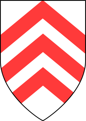
Bielefeld
City in North Rhine-Westphalia, Germany
Distance: Approx. 1701 meters
Latitude and longitude: 52.02111111,8.53472222
Bielefeld (German pronunciation: [ˈbiːləfɛlt] ) is a city in the Ostwestfalen-Lippe Region in the north-east of North Rhine-Westphalia, Germany. With a population of 341,755, it is also the most populous city in the administrative region (Regierungsbezirk) of Detmold and the 18th largest city in Germany. The historical centre of the city is situated north of the Teutoburg Forest line of hills, but modern Bielefeld also incorporates boroughs on the opposite side and on the hills.

Bethel Foundation
Psychiatric hospital in Bielefeld, Germany
Distance: Approx. 1705 meters
Latitude and longitude: 52.013259,8.522945
The Bethel Foundation, officially the Bodelschwingh Foundation Bethel (German: von Bodelschwinghsche Stiftungen Bethel as of 2009, previously v. Bodelschwinghsche Anstalten Bethel) is a diaconal (i.e. Protestant charitable) psychiatric hospital in Bethel, formerly a town, today a neighbourhood of Bielefeld, Germany, and the biggest social business in Europe.

6th Infantry Division (Wehrmacht)
Military unit
Distance: Approx. 1834 meters
Latitude and longitude: 52.0175,8.52472222
The 6th Infantry Division (6.

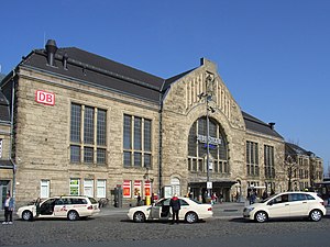
Bielefeld Hauptbahnhof
Railway station in North Rhine-Westphalia, Germany
Distance: Approx. 2518 meters
Latitude and longitude: 52.02833333,8.53166667
Bielefeld Hauptbahnhof is the main station in the region of Ostwestfalen-Lippe, in the German state of North Rhine-Westphalia. It is an important station because of the size of the city of Bielefeld and its location at the Bielefeld Pass, which makes it a node for long-distance and regional traffic. It was opened in 1847 with the opening of the Cologne-Minden trunk line.

Evangelical Church of Westphalia
United Protestant church body in North Rhine-Westphalia
Distance: Approx. 1780 meters
Latitude and longitude: 52.02138333,8.5331
The Protestant Church of Westphalia (German: Evangelische Kirche von Westfalen, EKvW) is a United Protestant church body in North Rhine-Westphalia. The seat of the praeses (German: Präses, the head of the church) is Bielefeld. The EKvW emerged on 13 June 1945, when the ecclesiastical province of Westphalia within the Lutheran Church of the old-Prussian Union assumed its independence as church body of its own.

Bielefelder Alm
Football stadium in Germany
Distance: Approx. 3383 meters
Latitude and longitude: 52.03194444,8.51666667
Bielefelder Alm (German pronunciation: [ˈbiːləfɛldɐ ˈʔalm] ) is a football stadium in Bielefeld, Germany which is home of the football club DSC Arminia Bielefeld and mostly used for the club's matches. Formerly named Stadion Alm [ˈʃtaːdi̯ɔn ˈʔalm], it is currently known as SchücoArena [ˈʃyːkoːʔaˈʁeːnaː] due to a sponsorship deal with the Bielefeld-based window, door, and façade manufacturers. The stadium currently has a capacity of 27,332 following the most recent major renovations completed in 2008.

Botanischer Garten Bielefeld
Distance: Approx. 2594 meters
Latitude and longitude: 52.01472222,8.51
The Botanischer Garten Bielefeld (4 hectares) is a municipal botanical garden located beside the southeast edge of the Teutoburger Wald at Am Kahlenberg 16, Bielefeld, North Rhine-Westphalia, Germany. It is open daily and free of charge. The garden was established in 1912 on one hectare.

Bielefeld Opera
Distance: Approx. 1665 meters
Latitude and longitude: 52.02083333,8.535
The Bielefeld Opera is the venue of Städtische Bühnen Bielefeld (Municipal stages Bielefeld) in Bielefeld, Germany. It is a Dreisparten Haus (three-department house), offering plays, music (opera, musical theatre), and ballet. The main performance venue is the Stadttheater am Niederwall (Municipal Theatre at the Lower Wall), built in 1904 and extensively renovated from 2004 to 2006.

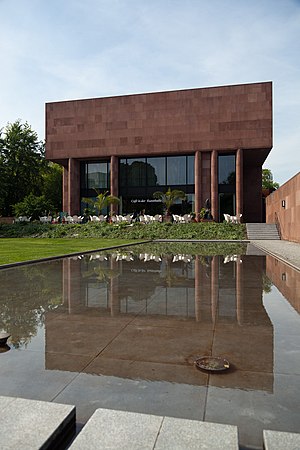
Kunsthalle Bielefeld
Art museum
Distance: Approx. 1799 meters
Latitude and longitude: 52.01805556,8.52611111
The Kunsthalle Bielefeld is a modern and contemporary art museum in Bielefeld, Germany. It was designed by Philip Johnson in 1968, and paid for by the businessman and art patron Rudolf August Oetker.

Bankhaus Lampe
German bank
Distance: Approx. 1718 meters
Latitude and longitude: 52.02027778,8.53194444
Bankhaus Lampe is an independent, private bank in Germany, founded in 1852 and headquartered in Bielefeld. The head office is in Düsseldorf, and additional offices are located in Germany, London, New York and Vienna. It is wholly owned by Hauck & Aufhäuser and focused on wealth management.

Natural History Museum, Bielefeld
Natural history museum in Kreuzstrasse in Bielefeld, Germany
Distance: Approx. 1616 meters
Latitude and longitude: 52.01713,8.52836
The Natural History Museum in Bielefeld (German: Naturkunde-Museum Bielefeld) is a natural history museum in the city of Bielefeld in North Rhine-Westphalia, Germany. Since 2003, it was given the additional name namu, which stands for the German words Natur (nature), Mensch (man), and Umwelt (environment). The exhibitions take place in the Spiegelshof, a historical building from the 14th century.

Rudolf-Oetker-Halle
Concert hall of Bielefeld, North Rhine-Westphalia, Germany
Distance: Approx. 3223 meters
Latitude and longitude: 52.02833333,8.51333333
The Rudolf-Oetker-Halle (ROH) is the concert hall of Bielefeld, North Rhine-Westphalia, Germany. It was built from 1928 to 1930 after designs by Düsseldorf architects Tietmann & Haake, opened on 31 October 1930. The listed monument is mostly in the original state and has excellent acoustics.
Weather in this IP's area
scattered clouds
3 Celsius
3 Celsius
2 Celsius
4 Celsius
1012 hPa
86 %
1012 hPa
995 hPa
10000 meters
0.89 m/s
2.68 m/s
255 degree
33 %