131.148.125.47 - IP Lookup: Free IP Address Lookup, Postal Code Lookup, IP Location Lookup, IP ASN, Public IP
Country:
Region:
City:
Location:
Time Zone:
Postal Code:
IP information under different IP Channel
ip-api
Country
Region
City
ASN
Time Zone
ISP
Blacklist
Proxy
Latitude
Longitude
Postal
Route
Luminati
Country
Region
fl
City
tampa
ASN
Time Zone
America/New_York
ISP
SPACECOASTCREDITUNIONMAIN
Latitude
Longitude
Postal
IPinfo
Country
Region
City
ASN
Time Zone
ISP
Blacklist
Proxy
Latitude
Longitude
Postal
Route
IP2Location
131.148.125.47Country
Region
florida
City
melbourne
Time Zone
America/New_York
ISP
Language
User-Agent
Latitude
Longitude
Postal
db-ip
Country
Region
City
ASN
Time Zone
ISP
Blacklist
Proxy
Latitude
Longitude
Postal
Route
ipdata
Country
Region
City
ASN
Time Zone
ISP
Blacklist
Proxy
Latitude
Longitude
Postal
Route
Popular places and events near this IP address

Florida Power and Light Company Ice Plant
United States historic place
Distance: Approx. 227 meters
Latitude and longitude: 28.08295,-80.60601
The Florida Power and Light Company Ice Plant (also known as the City Products Corporation Ice Plant or locally as the Ice Plant) is a historic site in Melbourne, Florida, United States, formerly operated by Florida Power & Light. It is located at 1604 South Harbor City Boulevard. On November 17, 1982, it was added to the U.S. National Register of Historic Places.

Holy Trinity Episcopal Academy
Private school in Melbourne, Brevard, Florida, United States
Distance: Approx. 1424 meters
Latitude and longitude: 28.081,-80.6224
Holy Trinity Episcopal Academy in Melbourne, Florida, is an Episcopal coeducational college-preparatory school for grades preschool – 12th. It was founded in 1957. The school operates under the guidance of Holy Trinity Episcopal Church, the Episcopal Diocese of Central Florida and the National Association of Independent Schools.

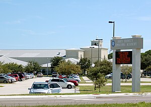
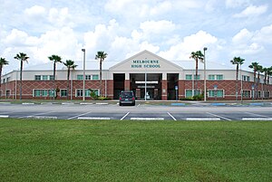
Melbourne High School (Melbourne, Florida)
Public secondary school in Melbourne, Florida, United States
Distance: Approx. 1413 meters
Latitude and longitude: 28.0900157,-80.6206091
Melbourne High School or Mel-Hi is a public secondary school located in Melbourne, Florida, United States and operated by Brevard Public Schools.

Nannie Lee House
Wood in Melbourne, Florida
Distance: Approx. 756 meters
Latitude and longitude: 28.079474,-80.602088
The Nannie Lee House, often referred to as Strawberry Mansion, is a historic U.S. home located at 1218 East New Haven Avenue, Melbourne, Florida. John B. Lee and his wife Nannie McBride Lee from Albion, New York built the house in 1905. Lily Tidwell, adopted granddaughter of Nannie Lee, inherited the house in 1929, and her family lived there for many years.

Holy Trinity Episcopal Church (Melbourne, Florida)
Distance: Approx. 1518 meters
Latitude and longitude: 28.080206,-80.623166
The Holy Trinity Episcopal Church was a historic church currently located at 50 West Strawbridge Avenue, Melbourne, Florida, United States. It is the oldest established church of any denomination in the city.
Holy Trinity Episcopal Church Parish (Melbourne, Florida)
Church
Distance: Approx. 1518 meters
Latitude and longitude: 28.080206,-80.623166
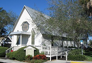
Holy Trinity Episcopal Church, founded in 1884 and now located at 50 West Strawbridge Avenue in Melbourne, Florida, in the United States, is a historic parish in the Episcopal Diocese of Central Florida. Holy Trinity is the oldest church organization in Melbourne. Its original church building, now the chapel, is a historic Carpenter Gothic church built in 1886.

Henegar Center
Distance: Approx. 650 meters
Latitude and longitude: 28.07805,-80.61025
The Henegar Center is a historic U.S. building located at 625 East New Haven Avenue, Melbourne, Florida. Built in 1919, it is one of Brevard County’s oldest public buildings. On March 12, 1963, the building received its name in honor of Ruth Henegar, a long-time teacher and principal at the school that used the building at the time.

Crane Creek (Melbourne, Florida)
River in Florida, United States
Distance: Approx. 1717 meters
Latitude and longitude: 28.0718773,-80.6195645
Crane Creek is a 3.3-mile-long (5.3 km) stream in Melbourne, Florida, United States. It is a tributary of the Indian River, with its mouth in the vicinity of Front Street.

Myles Building
Building in Florida, United States
Distance: Approx. 656 meters
Latitude and longitude: 28.07822,-80.60548
The Myles Building is a historic building located at 911-919 East New Haven Avenue, Melbourne, Florida. This two story building was constructed in 1913 and included a restaurant and billiard parlor on the first floor and the Midway Hotel on the second. Soon after completion, the Melbourne Times newspaper relocated to the Myles Building.

1900 Building
Distance: Approx. 672 meters
Latitude and longitude: 28.07942,-80.60326
The 1900 Building is a historic U.S. building located at 1900 South Harbor City Boulevard, Melbourne, Florida. This three story building was constructed in 1924 and originally opened as the Melbourne Hotel. The building housed several businesses through the years, including a bank, specialty stores and professional offices.
Holmes Regional Medical Center
Hospital in Florida, United States
Distance: Approx. 735 meters
Latitude and longitude: 28.0874231,-80.6143055
The Holmes Regional Medical Center is a not-for-profit hospital operated by Health First. It is located in Melbourne, Florida. It is a 514-bed facility, including the only level II trauma center in Brevard County.

Green Gables (Melbourne, Florida)
United States historic place
Distance: Approx. 258 meters
Latitude and longitude: 28.085,-80.60611111
Green Gables, also known as the Wells House, is a historic home at 1501 South Harbor City Boulevard in Melbourne, Florida, United States. The house fronts the Indian River. Local business man William T. Wells purchased the Strobah property and built the Green Gables in 1886 with his wife Nora Stanford Wells as a winter home.
Weather in this IP's area
clear sky
12 Celsius
11 Celsius
11 Celsius
13 Celsius
1020 hPa
73 %
1020 hPa
1020 hPa
10000 meters
3.58 m/s
4.92 m/s
311 degree