131.108.235.153 - IP Lookup: Free IP Address Lookup, Postal Code Lookup, IP Location Lookup, IP ASN, Public IP
Country:
Region:
City:
Location:
Time Zone:
Postal Code:
IP information under different IP Channel
ip-api
Country
Region
City
ASN
Time Zone
ISP
Blacklist
Proxy
Latitude
Longitude
Postal
Route
Luminati
Country
Region
cr
City
sanpedrosula
ASN
Time Zone
America/Tegucigalpa
ISP
ASOCIACION DE SERVICIO DE INTERNET S. DE RL.
Latitude
Longitude
Postal
IPinfo
Country
Region
City
ASN
Time Zone
ISP
Blacklist
Proxy
Latitude
Longitude
Postal
Route
IP2Location
131.108.235.153Country
Region
santa barbara
City
santa barbara
Time Zone
America/Tegucigalpa
ISP
Language
User-Agent
Latitude
Longitude
Postal
db-ip
Country
Region
City
ASN
Time Zone
ISP
Blacklist
Proxy
Latitude
Longitude
Postal
Route
ipdata
Country
Region
City
ASN
Time Zone
ISP
Blacklist
Proxy
Latitude
Longitude
Postal
Route
Popular places and events near this IP address

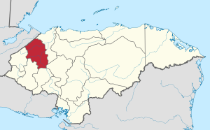
Santa Bárbara Department, Honduras
Department in Honduras
Distance: Approx. 5 meters
Latitude and longitude: 14.91666667,-88.23333333
Santa Bárbara is one of the 18 departments (departamentos) into which Honduras is divided. The departmental capital is Santa Bárbara.

Santa Bárbara, Honduras
Municipality in Santa Bárbara, Honduras
Distance: Approx. 5 meters
Latitude and longitude: 14.91666667,-88.23333333
Santa Bárbara, with a population of 30,690 (2023 calculation), is the capital city of the Santa Bárbara Department of Honduras and the municipal seat of Santa Bárbara Municipality.
San Nicolás, Santa Bárbara
Municipality in Santa Bárbara, Honduras
Distance: Approx. 9156 meters
Latitude and longitude: 14.93333333,-88.31666667
San Nicolás is a municipality in the Honduran department of Santa Bárbara. About six thousand people live in San Nicolás. The economy consists primarily of coffee farmers and workers from the surrounding area.
Santa Rita, Santa Bárbara
Municipality in Santa Bárbara, Honduras
Distance: Approx. 7647 meters
Latitude and longitude: 14.946,-88.169
Santa Rita SANTA BÁRBARA is a municipality in the Honduran department of Santa Bárbara.
San Vicente Centenario
Municipality in Santa Bárbara, Honduras
Distance: Approx. 6540 meters
Latitude and longitude: 14.88333333,-88.28333333
San Vicente Centenario (Spanish pronunciation: [sam biˈsente senteˈnaɾjo]) is a municipality in the Honduran department of Santa Bárbara.
Estadio Argelio Sabillón
Distance: Approx. 1731 meters
Latitude and longitude: 14.92611111,-88.24611111
Estadio Argelio Sabillón is a multi-purpose stadium in Santa Bárbara, Honduras. It is currently used mostly for football matches and is the home stadium of Real Juventud. The stadium holds 5 000 people.
Jicatuyo River
River in Honduras
Distance: Approx. 7356 meters
Latitude and longitude: 14.9772,-88.2608
The Jicatuyo River is a river in the Santa Barbara Department in Honduras which flows into the Ulúa River.
Otoro River
River in Honduras
Distance: Approx. 7325 meters
Latitude and longitude: 14.9769,-88.2608
The Otoro River, also known as the Grande de Otoro River, is a river in Honduras which begins in the department of Intibucá and then becomes the Ulúa River in the Santa Barbara Department. One of its more famous tributaries is the Río Gualcarque. This river is the proposed site for the Agua Zarca Dam, which came to international prominence when Berta Cáceres was assassinated for her work opposing this dam.
Santa Bárbara Airport (Honduras)
Airport
Distance: Approx. 2532 meters
Latitude and longitude: 14.93805556,-88.24138889
Santa Bárbara Airport (ICAO: MHSB) was an airport formerly serving Santa Bárbara, capital of the Santa Bárbara Department of Honduras. Current aerial images show a power line running down the middle of the former grass runway. Google Earth Historical Imagery (12/31/2010, 2/16/2015, 3/7/2018) show construction progressively covering both ends of the runway.
Weather in this IP's area
light rain
24 Celsius
24 Celsius
24 Celsius
24 Celsius
1020 hPa
79 %
1020 hPa
983 hPa
10000 meters
1.64 m/s
2.8 m/s
344 degree
99 %