131.100.142.36 - IP Lookup: Free IP Address Lookup, Postal Code Lookup, IP Location Lookup, IP ASN, Public IP
Country:
Region:
City:
Location:
Time Zone:
Postal Code:
ISP:
ASN:
language:
User-Agent:
Proxy IP:
Blacklist:
IP information under different IP Channel
ip-api
Country
Region
City
ASN
Time Zone
ISP
Blacklist
Proxy
Latitude
Longitude
Postal
Route
db-ip
Country
Region
City
ASN
Time Zone
ISP
Blacklist
Proxy
Latitude
Longitude
Postal
Route
IPinfo
Country
Region
City
ASN
Time Zone
ISP
Blacklist
Proxy
Latitude
Longitude
Postal
Route
IP2Location
131.100.142.36Country
Region
la union
City
la paz
Time Zone
America/El_Salvador
ISP
Language
User-Agent
Latitude
Longitude
Postal
ipdata
Country
Region
City
ASN
Time Zone
ISP
Blacklist
Proxy
Latitude
Longitude
Postal
Route
Popular places and events near this IP address

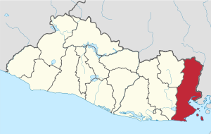
La Unión Department
Department of El Salvador
Distance: Approx. 6707 meters
Latitude and longitude: 13.542,-87.88
La Unión (Spanish pronunciation: [lawˈnjon]) is the easternmost department of El Salvador. Its capital is La Unión. It covers a total of 2,074 square kilometres (801 sq mi) and has a population of 263,200.

Bolívar, El Salvador
Municipality in La Unión, El Salvador
Distance: Approx. 2237 meters
Latitude and longitude: 13.58333333,-87.95
Bolívar is a municipality (municipio) in La Unión Department of El Salvador.

Santa Rosa de Lima, El Salvador
Municipality in La Unión Department, El Salvador
Distance: Approx. 6520 meters
Latitude and longitude: 13.61666667,-87.9
Santa Rosa de Lima is a municipality in La Unión Department of El Salvador. The city is named after St. Rose of Lima, born on 1586 in Lima (Peru).

Yucuaiquín
Municipality in La Unión Department, El Salvador
Distance: Approx. 7321 meters
Latitude and longitude: 13.55,-88
Yucuaiquin is a municipality in La Unión Department of El Salvador, located on the slopes of Cerro La Cruz.
Estadio Jose Ramon Flores
Distance: Approx. 8541 meters
Latitude and longitude: 13.63222222,-87.89027778
Estadio Jose Ramon Flores is a multi-use sports complex located in Santa Rosa de Lima, El Salvador. The sports complex is mainly used for its soccer facility. The soccer field is the home field of C.D. Municipal Limeño, a first division soccer team with a capacity of 5,000.
Santa Rosa de Lima Airport
Airport
Distance: Approx. 9451 meters
Latitude and longitude: 13.61611111,-87.8625
Santa Rosa de Lima Airport is an airport serving the city of Santa Rosa de Lima in La Unión Department, El Salvador. The runway is 3 kilometres (1.9 mi) east of the city. There is distant rising terrain south through southwest.
Weather in this IP's area
clear sky
20 Celsius
20 Celsius
20 Celsius
20 Celsius
1015 hPa
72 %
1015 hPa
997 hPa
10000 meters
1.72 m/s
1.92 m/s
359 degree