Country:
Region:
City:
Latitude and Longitude:
Time Zone:
Postal Code:
IP information under different IP Channel
ip-api
Country
Region
City
ASN
Time Zone
ISP
Blacklist
Proxy
Latitude
Longitude
Postal
Route
Luminati
Country
Region
md
City
halethorpe
ASN
Time Zone
America/New_York
ISP
UMBC-AS
Latitude
Longitude
Postal
IPinfo
Country
Region
City
ASN
Time Zone
ISP
Blacklist
Proxy
Latitude
Longitude
Postal
Route
db-ip
Country
Region
City
ASN
Time Zone
ISP
Blacklist
Proxy
Latitude
Longitude
Postal
Route
ipdata
Country
Region
City
ASN
Time Zone
ISP
Blacklist
Proxy
Latitude
Longitude
Postal
Route
Popular places and events near this IP address

Elkridge, Maryland
Census-designated place in Maryland, United States of America
Distance: Approx. 2550 meters
Latitude and longitude: 39.21583333,-76.70916667
Elkridge is an unincorporated community and census-designated place (CDP) in Howard County, Maryland, United States. The population was 15,593 at the 2010 census. Founded early in the 18th century, Elkridge is adjacent to two other counties, Anne Arundel and Baltimore.
Halethorpe, Maryland
Unincorporated community in Maryland, United States
Distance: Approx. 1885 meters
Latitude and longitude: 39.23972222,-76.68027778
Halethorpe is an unincorporated community in Baltimore County, Maryland, United States. The community is considered to be a sub-section of Arbutus by the United States Census Bureau. It is bordered by the main portion of Arbutus to the north, Baltimore to the North East, Elkridge to the South West, and Linthicum to the East.
Relay, Maryland
Distance: Approx. 2569 meters
Latitude and longitude: 39.22394,-76.710749
Relay, Maryland, or Relay House, Maryland, was formerly an important junction and rail stop on the Baltimore and Ohio Railroad, located 9 miles (14 km) west of Baltimore, Maryland. It was the busiest station on the line except for Baltimore itself. A town grew up around it: a general store, a school, and a volunteer fire company.

Halethorpe station
Railway station in Halethorpe, Maryland
Distance: Approx. 1953 meters
Latitude and longitude: 39.2385,-76.6911
Halethorpe station is a passenger rail station located in the unincorporated community of Halethorpe, Maryland, on the Northeast Corridor. MARC Penn Line trains serve the station; Amtrak trains pass through but do not stop. Halethorpe station is located along Southwestern Boulevard (US 1) beneath a bridge for Francis Avenue, which also contains a staircase leading between the station and the bridge.
St. Denis station (MARC)
Rail station in Baltimore County, Maryland, US
Distance: Approx. 1973 meters
Latitude and longitude: 39.2243,-76.7038
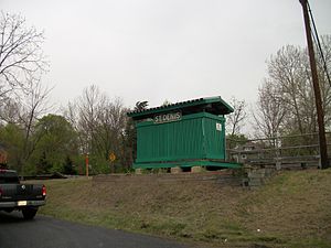
St. Denis station is a passenger rail station on the MARC Camden Line in the Maryland town of the same name. While the small station is the line's closest station to its terminus at Camden Yards in Baltimore, it has low ridership.
Elkridge Furnace Complex
United States historic place
Distance: Approx. 2211 meters
Latitude and longitude: 39.21305556,-76.70333333
The Elkridge Furnace Complex is a historic iron works located on about 16 acres (6.5 ha) at Elkridge, Howard County, Maryland.

Friendship Annex
Distance: Approx. 2531 meters
Latitude and longitude: 39.2008,-76.6884
The Friendship Annex, also known as FANX or FANEX, is a National Security Agency (NSA) facility complex located in Linthicum, Maryland, near the Baltimore Washington International Airport (BWI). Established in the 1970s, the complex consists of multiple buildings and serves multiple roles as a cyber espionage station, electronic intelligence processing facility, and NSA Broadcast Network television studio. It is also the primary campus of the National Cryptologic School.
Heavy Seas Beer
Brewed by Clipper City Brewing Company, in Baltimore, Maryland
Distance: Approx. 994 meters
Latitude and longitude: 39.23055556,-76.67527778
Heavy Seas Beer is brewed by Clipper City Brewing Company, in Baltimore, Maryland. The brewery was established by Hugh Sisson in 1995. Previously, Sisson operated Maryland's first brewpub, Sisson's.
Deep Run (Patapsco River tributary)
River
Distance: Approx. 1672 meters
Latitude and longitude: 39.21352778,-76.69625
Deep Run is an 11.9-mile-long (19.2 km) tributary of the Patapsco River in central Maryland in the United States. The main stem arises in the vicinity of Ellicott City, starting in the Montgomery Meadows housing development, and the lower course forms part of the border between Howard and Anne Arundel Counties. It passes underneath Route 100 twice, Interstate 95 once, and Route 1 once as well.
William P. Didusch Center for Urologic History
Distance: Approx. 1613 meters
Latitude and longitude: 39.20958333,-76.67333333
The William P. Didusch Center for Urologic History is a museum and the headquarters of the American Urological Association in Linthicum, Maryland.
Herbert Run
River in Maryland, United States
Distance: Approx. 799 meters
Latitude and longitude: 39.22096,-76.68996
Herbert Run is a .413-mile-long (0.665 km) stream that flows through Baltimore County. It is a tributary of the Patapsco River, which flows into the Chesapeake Bay. Herbert Run divides into two tributaries, East Branch Herbert Run and West Branch Herbert Run, to the north.
First Baptist Church of Elkridge
Historic African American Church in Elkridge, Maryland, US
Distance: Approx. 2593 meters
Latitude and longitude: 39.2120744,-76.7076942
First Baptist Church of Elkridge, is a historic African American Church located at 5795 Paradise Ave in Elkridge, Maryland. The building was constructed in 1877.
Weather in this IP's area
overcast clouds
12 Celsius
12 Celsius
11 Celsius
13 Celsius
1016 hPa
72 %
1016 hPa
1014 hPa
10000 meters
4.63 m/s
7.72 m/s
330 degree
100 %
06:51:55
16:51:33

