130.51.192.117 - IP Lookup: Free IP Address Lookup, Postal Code Lookup, IP Location Lookup, IP ASN, Public IP
Country:
 USA
USARegion:
City:
Location:
Time Zone:
Postal Code:
ISP:
ASN:
language:
User-Agent:
Proxy IP:
Blacklist:
IP information under different IP Channel
ip-api
Country
Region
City
ASN
Time Zone
ISP
Blacklist
Proxy
Latitude
Longitude
Postal
Route
db-ip
Country
Region
City
ASN
Time Zone
ISP
Blacklist
Proxy
Latitude
Longitude
Postal
Route
IPinfo
Country
Region
City
ASN
Time Zone
ISP
Blacklist
Proxy
Latitude
Longitude
Postal
Route
IP2Location
130.51.192.117Country
usRegion
washington
City
lopez island
Time Zone
America/Los_Angeles
ISP
Language
User-Agent
Latitude
Longitude
Postal
ipdata
Country
Region
City
ASN
Time Zone
ISP
Blacklist
Proxy
Latitude
Longitude
Postal
Route
Popular places and events near this IP address
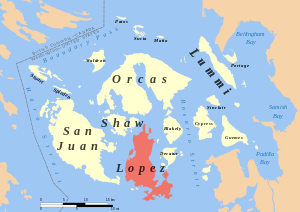
Lopez Island
Island of the San Juan Islands in Washington state, United States
Distance: Approx. 5198 meters
Latitude and longitude: 48.47888889,-122.89194444
Lopez Island is the third largest of the San Juan Islands and an unincorporated town in San Juan County, Washington, United States. Lopez Island is 29.81 square miles (77.2 km2) in land area. The 2020 census population was 3,156, though the population swells in the summer, as second homes, rental houses, and campsites fill up.

Decatur Island
Island of the San Juan Islands in northwest Washington, United States
Distance: Approx. 7494 meters
Latitude and longitude: 48.510236,-122.810926
Decatur Island is one of the San Juan Islands in Washington state, USA. Located just east of Lopez Island across Lopez Sound and just south of Blakely Island across Thatcher Pass, it is 3.524 square miles (9.127 km²) in area, and was named by the Wilkes Expedition in 1841 for naval officer Stephen Decatur.

Goose Island (San Juan Islands)
Distance: Approx. 8595 meters
Latitude and longitude: 48.45808333,-122.95680556
Goose Island is one of the San Juan Islands in San Juan County, Washington, United States.
Center Island (Washington)
Island of the San Juan Islands in northwest Washington, United States
Distance: Approx. 4953 meters
Latitude and longitude: 48.49,-122.8309
Center Island is one of the San Juan Islands in San Juan County, Washington, United States. It lies off the eastern shore of Lopez Island, between it and Decatur Island. Center Island has a land area of 0.713 km2 (0.275 sq mi; 176 acres).
James Island (San Juan Islands)
Island of the San Juan Islands in Washington state, United States
Distance: Approx. 8885 meters
Latitude and longitude: 48.5125,-122.775
James Island is one of the San Juan Islands in San Juan County, Washington, United States. It lies in Rosario Strait just off the eastern shore of Decatur Island and west of the city of Anacortes. The entire island comprises James Island Marine State Park of the Washington State Park System.
Iceberg Island
Distance: Approx. 4097 meters
Latitude and longitude: 48.42722222,-122.88941667
Iceberg Island is an island in the San Juan Islands of the U.S. state of Washington. The name comes from the nearby Iceberg Point on Lopez Island. Iceberg Point was named by the U.S. Coast Survey of 1854 because of "remarkable deep and smooth marks of glacial action".
Colville Island
Distance: Approx. 3760 meters
Latitude and longitude: 48.415,-122.82194444
Colville Island is an island in the San Juan Islands of the U.S. state of Washington. It lies near Point Colville, on the southeastern tip of Lopez Island. The island and the point were named for Andrew Colville, the governor of the Hudson's Bay Company, 1852–56.
Castle Island (Washington)
Island in Washington, United States
Distance: Approx. 3145 meters
Latitude and longitude: 48.42111111,-122.82194444
Castle Island is an island in the San Juan Islands of Washington state in the United States. It is located just off the southern tip of Lopez Island. The island, having a formidable look, was named Old Hundred Island by the U.S. Coast Survey of 1855.
Center Island Airport
Airport in San Juan County, Washington
Distance: Approx. 4944 meters
Latitude and longitude: 48.49,-122.83166667
Center Island Airport (IATA: CWS, FAA LID: 78WA) is a private use airport located on Center Island, in San Juan County, Washington, United States. The airport is owned by the Center Island Association. It was included in the National Plan of Integrated Airport Systems for 2011–2015, which categorized it as a general aviation facility.
Fortress Island
Island of the United States
Distance: Approx. 2160 meters
Latitude and longitude: 48.4653786,-122.8385103
Fortress Island is one of the San Juan Islands in San Juan County, Washington, USA. Located in Lopez Sound, the uninhabited, rocky island has a land area of 3.21 acres (1.30 hectares) and is almost completely devoid of vegetation. It is part of the Turtleback complex, a series of intrusive rocks in Lopez Sound formed out of crystallized molten magma that also includes Bird Rock, Low Island, and others. Fortress Island is part of the San Juan Islands National Wildlife Refuge and is managed by the U.S. Fish and Wildlife Service.
Deadman Island
Distance: Approx. 7628 meters
Latitude and longitude: 48.4581548,-122.9435105
Deadman Island is one of the San Juan Islands in San Juan County, Washington, United States. The uninhabited, rocky island has a land area of 3.5 acres (1.4 hectares). It is part of the Geese Islets, a collection of rocky islands and reefs near the southwest shore of Lopez Island.
Islandale, Washington
Unincorporated community in San Juan County, Washington
Distance: Approx. 1180 meters
Latitude and longitude: 48.44611111,-122.85777778
Islandale is an unincorporated community in San Juan County, in the U.S. state of Washington.
Weather in this IP's area
clear sky
-3 Celsius
-6 Celsius
-4 Celsius
-2 Celsius
1018 hPa
80 %
1018 hPa
1016 hPa
10000 meters
2.06 m/s
150 degree