130.45.113.76 - IP Lookup: Free IP Address Lookup, Postal Code Lookup, IP Location Lookup, IP ASN, Public IP
Country:
Region:
City:
Location:
Time Zone:
Postal Code:
ISP:
ASN:
language:
User-Agent:
Proxy IP:
Blacklist:
IP information under different IP Channel
ip-api
Country
Region
City
ASN
Time Zone
ISP
Blacklist
Proxy
Latitude
Longitude
Postal
Route
db-ip
Country
Region
City
ASN
Time Zone
ISP
Blacklist
Proxy
Latitude
Longitude
Postal
Route
IPinfo
Country
Region
City
ASN
Time Zone
ISP
Blacklist
Proxy
Latitude
Longitude
Postal
Route
IP2Location
130.45.113.76Country
Region
texas
City
waco
Time Zone
America/Chicago
ISP
Language
User-Agent
Latitude
Longitude
Postal
ipdata
Country
Region
City
ASN
Time Zone
ISP
Blacklist
Proxy
Latitude
Longitude
Postal
Route
Popular places and events near this IP address

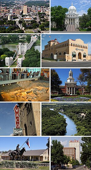
Waco, Texas
City in Texas, United States
Distance: Approx. 885 meters
Latitude and longitude: 31.55138889,-97.15583333
Waco ( WAY-koh) is a city in and the county seat of McLennan County, Texas, United States. It is situated along the Brazos River and I-35, halfway between Dallas and Austin. The city had a U.S. census estimated 2023 population of 144,816, making it the 24th-most populous city in the state.
Floyd Casey Stadium
Former football stadium in Waco, Texas
Distance: Approx. 2019 meters
Latitude and longitude: 31.53134167,-97.14873056
Floyd Casey Stadium was a stadium in Waco, Texas. The stadium was used for 64 seasons before being replaced by McLane Stadium in 2014. It was primarily used for football and was the home field of the Baylor Bears.

Lynching of Jesse Washington
1916 event in Waco, Texas, United States
Distance: Approx. 1901 meters
Latitude and longitude: 31.55833333,-97.12972222
Jesse Washington was a seventeen-year-old African American farmhand who was lynched in the county seat of Waco, Texas, on May 15, 1916, in what became a well-known example of lynching. Washington was convicted of raping and murdering Lucy Fryer, the wife of his white employer in rural Robinson, Texas. He was chained by his neck and dragged out of the county court by observers.

ALICO Building
Building in Waco, Texas
Distance: Approx. 1639 meters
Latitude and longitude: 31.557,-97.132
The ALICO Building is a 22-story office building in downtown Waco, Texas, United States, located at the intersection of Austin and 5th Street. The building is currently owned and operated by the American-Amicable Life Insurance Company of Texas (a subsidiary of Industrial Alliance). At 282 feet (86 m) tall, it is currently the tallest building in Waco.
Waco Independent School District
School district in Texas
Distance: Approx. 432 meters
Latitude and longitude: 31.546,-97.149
Waco Independent School District is a public school district based in Waco, Texas (USA). The district serves Beverly Hills and most of Waco. In 2009, the school district was rated "academically acceptable" by the Texas Education Agency.

Waco Tribune-Herald
Newspaper in Waco, Texas
Distance: Approx. 1282 meters
Latitude and longitude: 31.55271944,-97.13386111
The Waco Tribune-Herald is an American daily newspaper serving Waco, Texas, and vicinity.
Waco metropolitan area
Distance: Approx. 311 meters
Latitude and longitude: 31.55,-97.15
The Waco metropolitan statistical area, as defined by the United States Census Bureau, is an area consisting of McLennan, Falls and Bosque counties in Central Texas, anchored by the city of Waco. As of the 1 April 2020 census (which includes all 3 Counties), the MSA had a population of 295,782. The 2023 population estimate was 304,865 which includes Bosque County (added to the Waco MSA in 2023).
Katy Park
Baseball park in Waco, Texas, US
Distance: Approx. 1579 meters
Latitude and longitude: 31.5525,-97.13055556
Katy Park was a baseball park located in Waco, Texas, and was used by many minor league baseball teams as well as the Baylor Bears for a short time.

Municipal Stadium (Waco)
Athletics stadium in Waco, Texas, United States
Distance: Approx. 1640 meters
Latitude and longitude: 31.54211,-97.131781
Municipal Stadium, or Waco Municipal Stadium and formerly Waco Stadium, is an athletics stadium located in Waco, Texas at S 15th Street and Dutton Avenue. It was formerly the home field of Baylor University's athletic teams from the time shortly after the stadium was built in 1936 until 1949. For the Bears, the new off-campus facility replaced the smaller Carroll Field as the home football game location, where they had played from 1930 to 1935.

Praetorian Building (Waco, Texas)
United States historic place
Distance: Approx. 1541 meters
Latitude and longitude: 31.555,-97.13194444
The Praetorian Building is a historic 7-story building located at 601 Franklin Avenue in Waco, McLennan County, Texas. Designed by the Dallas architectural firm of C. W. Bulger & Co. in the Chicago school or Modern style of architecture, it was built in 1915 by Hughes O'Rourke Construction to house the Praetorian Insurance Company whose main office, the Praetorian Building in Dallas, had been designed by C. E. Bulger in 1905.

Cotton Palace
Exhibition ground in Waco, Texas, US
Distance: Approx. 1250 meters
Latitude and longitude: 31.5461,-97.1342
The Cotton Palace was an exhibition ground in the area of Clay Avenue, Dutton Avenue and South Sixteenth Street in Waco, Texas, from 1895 to 1930. It was built to highlight cotton-growing activities in the area.

Magnolia Market
American shopping complex
Distance: Approx. 1657 meters
Latitude and longitude: 31.55270389,-97.12977194
Magnolia Market at the Silos, commonly called Magnolia Market, is a shopping complex that encompasses two city blocks in downtown Waco, Texas. It is marked by two 120’ high silos, built in 1950 as part of the Brazos Valley Cotton Oil Company. The Brazos Valley Cotton Oil Mill Company closed in 1958, and the silos ceased to serve as storage in the 1990s.
Weather in this IP's area
overcast clouds
14 Celsius
13 Celsius
14 Celsius
14 Celsius
1006 hPa
63 %
1006 hPa
988 hPa
10000 meters
7.8 m/s
16.04 m/s
197 degree
98 %

