Country:
 USA
USARegion:
City:
Latitude and Longitude:
Time Zone:
Postal Code:
IP information under different IP Channel
ip-api
Country
Region
City
ASN
Time Zone
ISP
Blacklist
Proxy
Latitude
Longitude
Postal
Route
IPinfo
Country
Region
City
ASN
Time Zone
ISP
Blacklist
Proxy
Latitude
Longitude
Postal
Route
MaxMind
Country
Region
City
ASN
Time Zone
ISP
Blacklist
Proxy
Latitude
Longitude
Postal
Route
Luminati
Country
USRegion
ma
City
brighton
ASN
Time Zone
America/New_York
ISP
RCN-AS
Latitude
Longitude
Postal
db-ip
Country
Region
City
ASN
Time Zone
ISP
Blacklist
Proxy
Latitude
Longitude
Postal
Route
ipdata
Country
Region
City
ASN
Time Zone
ISP
Blacklist
Proxy
Latitude
Longitude
Postal
Route
Popular places and events near this IP address
Brighton, Boston
Neighborhood of Boston in Suffolk, Massachusetts, United States
Distance: Approx. 325 meters
Latitude and longitude: 42.35,-71.16
Brighton is a former town and current neighborhood of Boston, Massachusetts, United States, located in the northwestern corner of the city. It is named after the English city of Brighton. Initially Brighton was part of Cambridge, and known as "Little Cambridge".

St. Elizabeth's Medical Center (Boston)
Hospital in Boston, Massachusetts
Distance: Approx. 812 meters
Latitude and longitude: 42.3491,-71.1486
St. Elizabeth's Medical Center (abbreviated SEMC, also known locally as St. E's) is a mid-size non-profit teaching hospital located in the Brighton neighborhood of Boston, Massachusetts.
Boston College School of Theology and Ministry
Catholic seminary (2008-)
Distance: Approx. 680 meters
Latitude and longitude: 42.34277778,-71.16361111
The Gloria L. and Charles I. Clough School of Theology and Ministry (CSTM) is a Jesuit school of graduate theology at Boston College. It is an ecclesiastical faculty of theology that trains men and women, both lay and religious, for scholarship and service, especially within the Catholic Church.

Saint John's Seminary (Massachusetts)
Distance: Approx. 552 meters
Latitude and longitude: 42.34401389,-71.16310556
Saint John's Seminary, located in the Brighton neighborhood of Boston, Massachusetts, is a Catholic major seminary sponsored by the Roman Catholic Archdiocese of Boston. The current rector is Rev. Msgr.
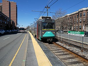
South Street station (MBTA)
Light rail station in Boston, Massachusetts, US
Distance: Approx. 878 meters
Latitude and longitude: 42.33953056,-71.15748889
South Street station is a light rail surface stop on the MBTA Green Line B branch, located in the median of Commonwealth Avenue east of South Street in the Brighton neighborhood of Boston, Massachusetts. South Street is the lowest-ridership stop on the B branch, with just 214 daily boardings by a 2011 survey. Track work in 2018–19, which included replacement of platform edges at several stops, triggered requirements for accessibility modifications at those stops.

Brighton Evangelical Congregational Church
Historic church in Massachusetts, United States
Distance: Approx. 299 meters
Latitude and longitude: 42.34891667,-71.15519444
Brighton Allston Congregational Church, known before 2003 as the Brighton Evangelical Congregational Church, is a historic church located at 404 Washington Street in the center of Brighton, a neighborhood of Boston, Massachusetts.

Brighton Center Historic District
Historic district in Massachusetts, United States
Distance: Approx. 348 meters
Latitude and longitude: 42.34833333,-71.15416667
The Brighton Center Historic District encompasses the civic center of the Brighton neighborhood of Boston, Massachusetts. The district is centered at the junction of Washington Street with Market Street and Chestnut Hill Avenue, radiating along those roads and including a number of immediately adjacent properties on adjacent streets. The oldest resource in the district is the Market Street Burial Ground, which was established in 1764.

Oak Square School
United States historic place
Distance: Approx. 922 meters
Latitude and longitude: 42.3501,-71.1688
Oak Square School is a historic school building at 35 Nonantum Street in Brighton, Massachusetts, a neighborhood of Boston, Massachusetts. The school was designed by Edmund March Wheelwright, who designed a wide variety of Boston landmark buildings. It was built in 1894 on the site of Breck Gardens and had a major addition in 1923.

Oak Square station
Boston MBTA former subway station
Distance: Approx. 896 meters
Latitude and longitude: 42.35066667,-71.16815278
Oak Square is a former station on the Green Line A branch. It was closed in 1969 when service on the branch was replaced with buses.

Harrington Athletics Village
Sports complex at Boston College
Distance: Approx. 455 meters
Latitude and longitude: 42.3435,-71.15986111
The Harrington Athletics Village is a sports complex located on the Brighton Campus at Boston College in Boston, Massachusetts, United States. The complex currently consists of the Eddie Pellagrini Diamond, which is home to the Boston College Eagles baseball team; the Boston College Softball Field, which is home to the softball team; and the Pete Frates Center, which is an indoor practice facility and hospitality area for the baseball and softball teams.
2000 Commonwealth Avenue collapse (1971)
Construction accident in Boston, Massachusetts, U.S.
Distance: Approx. 884 meters
Latitude and longitude: 42.33946,-71.15859
On January 25, 1971, a luxury condominium building under construction at 2000 Commonwealth Avenue in Brighton, Boston, Massachusetts, collapsed, killing 4 construction workers and injuring 30 others.: 176–183
Eddie Pellagrini Diamond
Distance: Approx. 455 meters
Latitude and longitude: 42.3435,-71.15986111
Eddie Pellagrini Diamond is a baseball stadium at the Harrington Athletics Village located in Boston College in Boston, Massachusetts, United States.
Weather in this IP's area
clear sky
16 Celsius
15 Celsius
14 Celsius
18 Celsius
1030 hPa
48 %
1030 hPa
1025 hPa
10000 meters
5.14 m/s
70 degree
07:01:18
17:57:44