Country:
 USA
USARegion:
City:
Latitude and Longitude:
Time Zone:
Postal Code:
IP information under different IP Channel
ip-api
Country
Region
City
ASN
Time Zone
ISP
Blacklist
Proxy
Latitude
Longitude
Postal
Route
IPinfo
Country
Region
City
ASN
Time Zone
ISP
Blacklist
Proxy
Latitude
Longitude
Postal
Route
MaxMind
Country
Region
City
ASN
Time Zone
ISP
Blacklist
Proxy
Latitude
Longitude
Postal
Route
Luminati
Country
USRegion
mi
City
harborbeach
ASN
Time Zone
America/Detroit
ISP
AGRI-VALLEY
Latitude
Longitude
Postal
db-ip
Country
Region
City
ASN
Time Zone
ISP
Blacklist
Proxy
Latitude
Longitude
Postal
Route
ipdata
Country
Region
City
ASN
Time Zone
ISP
Blacklist
Proxy
Latitude
Longitude
Postal
Route
Popular places and events near this IP address

Dwight Township, Michigan
Civil township in Michigan, United States
Distance: Approx. 5945 meters
Latitude and longitude: 43.97666667,-82.95666667
Dwight Township is a civil township of Huron County in the U.S. state of Michigan. The population was 708 at the 2020 census.

Pointe Aux Barques Township, Michigan
Civil township in Michigan, United States
Distance: Approx. 5474 meters
Latitude and longitude: 44.06138889,-82.95
Pointe Aux Barques Township ( poynt-ə-BARKS) is a civil township of Huron County in the U.S. state of Michigan. The population was 15 at the 2020 census. Pointe Aux Barques is located at the tip of the Thumb on the Lower Peninsula.

Port Austin, Michigan
Village in Michigan, United States
Distance: Approx. 2460 meters
Latitude and longitude: 44.04527778,-82.99444444
Port Austin is a village in Huron County in the U.S. state of Michigan. The population was 664 at the 2010 census. The village is within Port Austin Township.

Port Austin Township, Michigan
Civil township in Michigan, United States
Distance: Approx. 4267 meters
Latitude and longitude: 44.04305556,-82.9475
Port Austin Township is a civil township of Huron County in the U.S. state of Michigan. The population was 1,384 at the 2020 census.
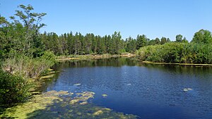
Pinnebog River
River
Distance: Approx. 5757 meters
Latitude and longitude: 44.00583333,-83.06083333
The Pinnebog River is a 39.4-mile-long (63.4 km) river in the Thumb region of the U.S. state of Michigan. The river flows into Lake Huron on the west side of the "tip" of the "thumb". The entire length of the Pinnebog lies within Huron County and is fed by various agricultural ditches and drains.

Port Crescent State Park
Park in Michigan, USA
Distance: Approx. 5366 meters
Latitude and longitude: 44.00472222,-83.055
Port Crescent State Park is a public recreation area on Lake Huron five miles (8.0 km) southwest of Port Austin in Huron County at the tip of The Thumb of Michigan. The state park covers 640 acres (260 ha) along state route M-25 in Hume Township. The park occupies the site of Port Crescent, a ghost town which once stood at the mouth of the Pinnebog River.
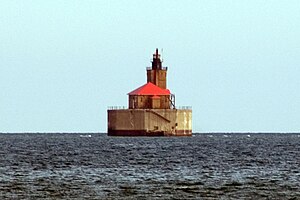
Port Austin Light
Lighthouse in Michigan, United States
Distance: Approx. 6739 meters
Latitude and longitude: 44.08333333,-82.98333333
Port Austin Lighthouse (or Port Austin Reef Light) is a lighthouse off the shore of Lake Huron, about 2.5 miles (4.0 km) north of Port Austin, Huron County Michigan sitting on a rocky reef (shoal), which is just north of the tip of the Thumb and a real hazard to navigation.
Port Austin Air Force Station
Closed United States Air Force General Surveillance Radar station
Distance: Approx. 1044 meters
Latitude and longitude: 44.03027778,-83.00166667
Port Austin Air Force Station (ADC ID: P-61, NORAD ID: Z-61) is a closed United States Air Force General Surveillance Radar station. It is located 1.2 miles (1.9 km) south-southwest Port Austin, Michigan. It was closed in 1988 by the Air Force.

Turnip Rock
Geological formation
Distance: Approx. 5715 meters
Latitude and longitude: 44.06834444,-82.95908056
Turnip Rock is a small geological formation in Michigan. It is a stack located in Lake Huron, in shallow water a few yards offshore, near the rock called the Thumbnail which is the extreme tip of Pointe Aux Barques, a small peninsula in Pointe Aux Barques Township which in turn is the extreme tip of The Thumb, a large peninsula comprising several counties in eastern Michigan. Turnip Rock has been severely undercut by wave action, so that its top has a significantly larger cross-section than its base.

Charles G. Learned House
United States historic place
Distance: Approx. 2118 meters
Latitude and longitude: 44.04222222,-82.99388889
The Charles G. Learned House was built as a private house located at 8544 Lake Street in Port Austin, Michigan. It was listed on the National Register of Historic Places in 1984. It is now a bed and breakfast known as the Garfield Inn, named after US President James A. Garfield, a family friend of the Learneds and frequent guest.

Winsor and Snover Bank Building
United States historic place
Distance: Approx. 2366 meters
Latitude and longitude: 44.04444444,-82.99388889
The Winsor and Snover Bank Building is a commercial structure located at 8648 Lake Street in Port Austin, Michigan. It was listed on the National Register of Historic Places in 1987. As of 2017, the building houses The Bank, 1884 restaurant.

Smith-Culhane House
United States historic place
Distance: Approx. 2214 meters
Latitude and longitude: 44.04305556,-82.99472222
The Smith-Culhane House is a private house located at 8569 Lake Street in Port Austin, Michigan. It was listed on the National Register of Historic Places in 2001. It was previously operated as a bed and breakfast, the Lake Street Manor, but was converted back to a private residence in 2021.
Weather in this IP's area
scattered clouds
17 Celsius
16 Celsius
17 Celsius
17 Celsius
1013 hPa
74 %
1013 hPa
991 hPa
10000 meters
1.54 m/s
140 degree
39 %
07:16:16
19:35:00