Country:
 USA
USARegion:
City:
Latitude and Longitude:
Time Zone:
Postal Code:
IP information under different IP Channel
ip-api
Country
Region
City
ASN
Time Zone
ISP
Blacklist
Proxy
Latitude
Longitude
Postal
Route
IPinfo
Country
Region
City
ASN
Time Zone
ISP
Blacklist
Proxy
Latitude
Longitude
Postal
Route
MaxMind
Country
Region
City
ASN
Time Zone
ISP
Blacklist
Proxy
Latitude
Longitude
Postal
Route
Luminati
Country
USRegion
mi
City
gagetown
ASN
Time Zone
America/Detroit
ISP
AGRI-VALLEY
Latitude
Longitude
Postal
db-ip
Country
Region
City
ASN
Time Zone
ISP
Blacklist
Proxy
Latitude
Longitude
Postal
Route
ipdata
Country
Region
City
ASN
Time Zone
ISP
Blacklist
Proxy
Latitude
Longitude
Postal
Route
Popular places and events near this IP address
Buel Township, Michigan
Township in Michigan, United States
Distance: Approx. 8358 meters
Latitude and longitude: 43.28027778,-82.72277778
Buel Township is a civil township of Sanilac County in the U.S. state of Michigan. As of the 2020 census, the township population was 1,161.

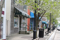
Croswell, Michigan
City in Michigan, United States
Distance: Approx. 1742 meters
Latitude and longitude: 43.27555556,-82.62111111
Croswell is a city in Sanilac County in the U.S. state of Michigan. The population was 2,447 at the 2010 census.
Lexington, Michigan
Village in Michigan, United States
Distance: Approx. 7349 meters
Latitude and longitude: 43.26861111,-82.53361111
Lexington is a village in Sanilac County in the U.S. state of Michigan. The population was 1,178 at the 2010 census. The village is located within Lexington Township.
Lexington Township, Michigan
Township in Michigan, United States
Distance: Approx. 6043 meters
Latitude and longitude: 43.28972222,-82.56111111
Lexington Township is a civil township of Sanilac County in the U.S. state of Michigan. The population was 3,485 at the 2020 census. The village of Lexington is located within the township.
Croswell-Lexington High School
School in Croswell, Michigan, United States
Distance: Approx. 1951 meters
Latitude and longitude: 43.2664,-82.6011
Croswell-Lexington High School, commonly abbreviated to simply "Cros-Lex", is a public secondary school in Croswell, Michigan.

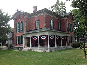
John L. Fead House
United States historic place
Distance: Approx. 7756 meters
Latitude and longitude: 43.27166667,-82.52916667
The John L. Fead House is a private house located at 5349 Washington Street in Lexington, Michigan. It was listed on the National Register of Historic Places in 1978.
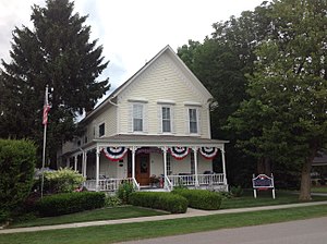
Charles H. Moore–Albert E. Sleeper House
United States historic place
Distance: Approx. 7607 meters
Latitude and longitude: 43.26944444,-82.53055556
The Charles H. Moore–Albert E. Sleeper House was built as a private house located, at 7277 Simons Street in Lexington, Michigan, and was the residence and later summer home of Michigan governor Albert E. Sleeper. It was listed on the National Register of Historic Places in 1985. The house is now a bed and breakfast, known as A Captain's Quarters Inn.

Moore Public Library (Lexington, Michigan)
United States historic place
Distance: Approx. 7435 meters
Latitude and longitude: 43.26833333,-82.5325
The Moore Public Library is a library building located at 7239 Huron Avenue Lexington, Michigan. The building was formerly a professional office, and was listed on the National Register of Historic Places in 1985.
William Reuben Nims House
United States historic place
Distance: Approx. 7155 meters
Latitude and longitude: 43.2675,-82.53583333
The William Reuben Nims House is a private house located at 7156 Huron Avenue in Lexington, Michigan. It was listed on the National Register of Historic Places in 1985.

Thomas and Margaret Spencer Matthews Farm
United States historic place
Distance: Approx. 6800 meters
Latitude and longitude: 43.20777778,-82.58
The Thomas and Margaret Spencer Matthews Farm is a farm located at 5916 East Gardner Line Road near Amadore, Michigan. It was listed on the National Register of Historic Places in 1995.

W.R. Roach Cannery Warehouse and Office Building
United States historic place
Distance: Approx. 1553 meters
Latitude and longitude: 43.2725,-82.615
The W.R. Roach Cannery Warehouse and Office Building is an industrial structure located at 89 East Sanborn in Croswell, Michigan. It was listed on the National Register of Historic Places in 2005, and now contains apartments, known as Cannery Village.

Cadillac House
United States historic place
Distance: Approx. 7435 meters
Latitude and longitude: 43.26833333,-82.5325
The Cadillac House is a hotel and restaurant located at 5502 Main Street in Lexington, Michigan. It was listed on the National Register of Historic Places in 2018.
Weather in this IP's area
few clouds
17 Celsius
17 Celsius
15 Celsius
18 Celsius
1013 hPa
78 %
1013 hPa
987 hPa
10000 meters
2.56 m/s
2.79 m/s
126 degree
14 %
07:16:04
19:31:30