Country:
 USA
USARegion:
City:
Latitude and Longitude:
Time Zone:
Postal Code:
IP information under different IP Channel
ip-api
Country
Region
City
ASN
Time Zone
ISP
Blacklist
Proxy
Latitude
Longitude
Postal
Route
IPinfo
Country
Region
City
ASN
Time Zone
ISP
Blacklist
Proxy
Latitude
Longitude
Postal
Route
MaxMind
Country
Region
City
ASN
Time Zone
ISP
Blacklist
Proxy
Latitude
Longitude
Postal
Route
Luminati
Country
USRegion
mi
City
applegate
ASN
Time Zone
America/Detroit
ISP
AGRI-VALLEY
Latitude
Longitude
Postal
db-ip
Country
Region
City
ASN
Time Zone
ISP
Blacklist
Proxy
Latitude
Longitude
Postal
Route
ipdata
Country
Region
City
ASN
Time Zone
ISP
Blacklist
Proxy
Latitude
Longitude
Postal
Route
Popular places and events near this IP address

Sanilac County, Michigan
County in Michigan, United States
Distance: Approx. 5250 meters
Latitude and longitude: 43.46,-82.64
Sanilac County ( SAN-ə-lack) is a county located in the Thumb region of the U.S. state of Michigan. As of the 2020 Census, the population was 40,611. The county seat is Sandusky.

Applegate, Michigan
Village in Michigan, United States
Distance: Approx. 7929 meters
Latitude and longitude: 43.35527778,-82.63694444
Applegate is a village in Sanilac County of the U.S. state of Michigan. The population was 241 at the 2020 census. Applegate is in the southeast corner of Washington Township on the boundary with Sanilac Township.
Bridgehampton Township, Michigan
Township in Michigan, United States
Distance: Approx. 9750 meters
Latitude and longitude: 43.46694444,-82.70527778
Bridgehampton Township is a civil township of Sanilac County in the U.S. state of Michigan. As of the 2020 census, the township population was 745.

Carsonville, Michigan
Village in Michigan, United States
Distance: Approx. 5835 meters
Latitude and longitude: 43.42555556,-82.67388889
Carsonville is a village in Sanilac County of the U.S. state of Michigan. The population was 527 at the 2010 census. The village is situated at 43°25′37″N 82°40′17″W on the boundary between Bridgehampton Township and Washington Township, with about half the village in each.

Sanilac Township, Michigan
Township in Michigan, United States
Distance: Approx. 3734 meters
Latitude and longitude: 43.40861111,-82.55944444
Sanilac Township is a civil township of Sanilac County in the U.S. state of Michigan. The population was 2,301 at the 2020 census. The village of Port Sanilac is within the township.
Washington Township, Sanilac County, Michigan
Township in Michigan, United States
Distance: Approx. 7458 meters
Latitude and longitude: 43.3875,-82.68111111
Washington Township is a civil township of Sanilac County in the U.S. state of Michigan. The population was 1,524 at the 2020 census.

Port Sanilac, Michigan
Village in Michigan, United States
Distance: Approx. 4832 meters
Latitude and longitude: 43.43138889,-82.54361111
Port Sanilac is a village in Sanilac Township, Sanilac County in the U.S. state of Michigan. The population was 567 at the 2020 census.
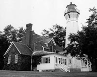
Port Sanilac Light
Lighthouse in Michigan, United States
Distance: Approx. 5066 meters
Latitude and longitude: 43.42888889,-82.54
Port Sanilac Light is a United States Coast Guard lighthouse located on Point Sanilac, near Port Sanilac on the eastern side of Michigan's Thumb. It is an automated and active aid to navigation on Lake Huron.

Port Sanilac Masonic and Town Hall
United States historic place
Distance: Approx. 4963 meters
Latitude and longitude: 43.43138889,-82.54194444
The Masonic and Town Hall, located at 20 North Ridge Street in Port Sanilac, Michigan, was constructed as a Masonic Lodge constructed in 1884. It was listed on the National Register of Historic Places in 1996.

Loop-Harrison Mansion
United States historic place
Distance: Approx. 4699 meters
Latitude and longitude: 43.42444444,-82.54388889
The Loop-Harrison Mansion, also known as the Joseph M. Loop House was built as a private house located at 228 South Ridge Street in Port Sanilac, Michigan. It now serves as part of the Sanilac County Historical Museum. The building was listed on the National Register of Historic Places in 1972.
Weather in this IP's area
few clouds
18 Celsius
19 Celsius
15 Celsius
18 Celsius
1013 hPa
92 %
1013 hPa
986 hPa
10000 meters
3.08 m/s
3.46 m/s
130 degree
21 %
07:15:57
19:31:27