Country:
 USA
USARegion:
City:
Latitude and Longitude:
Time Zone:
Postal Code:
IP information under different IP Channel
ip-api
Country
Region
City
ASN
Time Zone
ISP
Blacklist
Proxy
Latitude
Longitude
Postal
Route
IPinfo
Country
Region
City
ASN
Time Zone
ISP
Blacklist
Proxy
Latitude
Longitude
Postal
Route
MaxMind
Country
Region
City
ASN
Time Zone
ISP
Blacklist
Proxy
Latitude
Longitude
Postal
Route
Luminati
Country
USRegion
ma
City
peabody
ASN
Time Zone
America/New_York
ISP
RCN-AS
Latitude
Longitude
Postal
db-ip
Country
Region
City
ASN
Time Zone
ISP
Blacklist
Proxy
Latitude
Longitude
Postal
Route
ipdata
Country
Region
City
ASN
Time Zone
ISP
Blacklist
Proxy
Latitude
Longitude
Postal
Route
Popular places and events near this IP address

WEEI-FM
Sports radio station in Lawrence, Massachusetts, serving Boston
Distance: Approx. 1725 meters
Latitude and longitude: 42.53147222,-70.98616667
WEEI-FM (93.7 MHz) – branded SportsRadio 93.7 WEEI-FM – is a commercial sports radio station licensed to Lawrence, Massachusetts, serving Greater Boston and much of surrounding New England. Owned by Audacy, Inc., WEEI-FM is the Boston affiliate for Infinity Sports Network, the NFL on Westwood One Sports, the flagship station for the Boston Red Sox Radio Network; and the radio home of Greg Hill, Lou Merloni, Christian Fauria and Jermaine Wiggins. The WEEI-FM studios are located in Boston's Brighton neighborhood, while the station transmitter resides in the nearby suburb of Peabody.

Liberty Tree Mall
Shopping mall in Massachusetts, United States
Distance: Approx. 2974 meters
Latitude and longitude: 42.5524,-70.9398
The Liberty Tree Mall is a shopping mall in Danvers, Massachusetts, U.S., managed by the Simon Property Group. It is anchored by Kohl's, Total Wine & More, AMC Theatres, Marshalls, Old Navy, Sky Zone, and Best Buy, along with Aldi Simon Property Group owns one-third of the common area of the mall; the Michaels Strip Mall, and the entire interior space between Kohl's and Best Buy. The right-hand area of the property from Best Buy to Staples is owned by Target.

George Peabody House Museum
Historic house in Massachusetts, United States
Distance: Approx. 2758 meters
Latitude and longitude: 42.52111111,-70.93611111
The George Peabody House Museum is a historic house museum at 205 Washington Street in Peabody, Massachusetts. It is dedicated to the life and deeds of 19th century U.S. entrepreneur, philanthropist, and namesake of the city, George Peabody. The museum shares its location with the Peabody Leather Museum.

Nathaniel Felton Houses
Historic house in Massachusetts, United States
Distance: Approx. 1396 meters
Latitude and longitude: 42.54555556,-70.96111111
The Nathaniel Felton Houses are a pair of historic houses at 43 and 47 Felton Street in Peabody, Massachusetts. The Peabody Historical Society owns and operates the homes as historic house museums. The house of Nathaniel Felton Sr., at 47 Felton Street, was built c. 1700.

Moore–Hill House
Historic house in Massachusetts, United States
Distance: Approx. 2534 meters
Latitude and longitude: 42.52805556,-70.93527778
The Moore–Hill House is a historic house in Peabody, Massachusetts. It is an excellent example of a Gothic Victorian house, built in 1874 for W. H. Hill. The 1+1⁄2-story wood-frame building has a cross gable roof line, with the main roof line running crosswise.
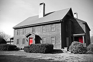
John Proctor House (Peabody, Massachusetts)
Historic house in Massachusetts, United States
Distance: Approx. 891 meters
Latitude and longitude: 42.53361111,-70.95444444
The John Proctor House is a historic First Period house in Peabody, Massachusetts, United States. According to local tradition, this wood-frame house was occupied by John Proctor, who was convicted and hanged for witchcraft during the Salem witch trials of 1692. However, dendrochronology has determined the house was built c. 1727 by Proctor's son Thorndike, who purchased the property from Charles Downing around that time.

Peabody Central Fire Station
United States historic place
Distance: Approx. 2888 meters
Latitude and longitude: 42.52722222,-70.93111111
The Peabody Central Fire Station is a historic fire station at 41 Lowell Street in Peabody, Massachusetts, United States. Built in 1873, the two story brick building is one of the oldest active fire stations in the state. The building has Victorian styling, with a mansard roof, and two truncated gables on its front facade.
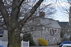
Southwick House (Peabody, Massachusetts)
Historic house in Massachusetts, United States
Distance: Approx. 2370 meters
Latitude and longitude: 42.53055556,-70.93666667
The Southwick House is a historic house in Peabody, Massachusetts. Probably built about 1750, it is one of the city's oldest surviving structures, and has a long association with a prominent local family. The house was listed on the National Register of Historic Places in 1983.
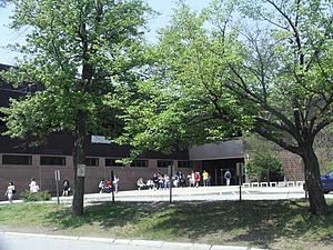
Peabody Veterans Memorial High School
Public high school in the United States
Distance: Approx. 1455 meters
Latitude and longitude: 42.54472222,-70.97416667
Peabody Veterans Memorial High School (PVMHS), also known as Peabody High School, is a comprehensive and competitive public high school in Peabody, Massachusetts, United States. It is the only comprehensive public high school in the Peabody School District, spanning grades 9–12 in the U.S. education system. It is particularly known for its performing arts program including instrumental and choral ensembles and drama club.
St. John's School fire
Deadly 1915 fire in Peabody, Massachusetts, US
Distance: Approx. 2993 meters
Latitude and longitude: 42.5258,-70.9303
The St. John's School fire was a deadly fire that occurred on the morning of October 28, 1915, at the St. John's School on Chestnut Street in the downtown area of Peabody, Massachusetts.
1984 U.S. Women's Open
Golf tournament
Distance: Approx. 327 meters
Latitude and longitude: 42.531,-70.963
The 1984 U.S. Women's Open was the 39th U.S. Women's Open, held July 12–15 at Salem Country Club in Peabody, Massachusetts. Hollis Stacy won her third U.S. Women's Open, one stroke ahead of runner-up Rosie Jones. It was Stacy's fourth and final major title.
1954 U.S. Women's Open
Golf tournament
Distance: Approx. 327 meters
Latitude and longitude: 42.531,-70.963
The 1954 U.S. Women's Open was the ninth U.S. Women's Open, held July 1–3 at Salem Country Club in Peabody, Massachusetts. It was the second conducted by the United States Golf Association (USGA). Babe Zaharias won her third U.S. Women's Open, twelve strokes ahead of runner-up Betty Hicks, a record victory margin which still stands.
Weather in this IP's area
few clouds
24 Celsius
23 Celsius
21 Celsius
26 Celsius
1024 hPa
48 %
1024 hPa
1020 hPa
10000 meters
5.66 m/s
100 degree
20 %
06:25:19
18:51:58