Country:
Region:
City:
Latitude and Longitude:
Time Zone:
Postal Code:
IP information under different IP Channel
ip-api
Country
Region
City
ASN
Time Zone
ISP
Blacklist
Proxy
Latitude
Longitude
Postal
Route
Luminati
Country
ASN
Time Zone
America/Chicago
ISP
CL-1379-14537
Latitude
Longitude
Postal
IPinfo
Country
Region
City
ASN
Time Zone
ISP
Blacklist
Proxy
Latitude
Longitude
Postal
Route
db-ip
Country
Region
City
ASN
Time Zone
ISP
Blacklist
Proxy
Latitude
Longitude
Postal
Route
ipdata
Country
Region
City
ASN
Time Zone
ISP
Blacklist
Proxy
Latitude
Longitude
Postal
Route
Popular places and events near this IP address

Gunnersbury
Area of west London, England
Distance: Approx. 340 meters
Latitude and longitude: 51.4927,-0.2777
Gunnersbury is an area of West London, England.

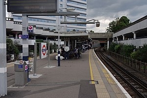
Gunnersbury station
London Underground and London Overground station
Distance: Approx. 313 meters
Latitude and longitude: 51.4918,-0.275
Gunnersbury is a London Overground and London Underground station in Gunnersbury in London, England on the North London line. The station opened on 1 January 1869 and is served by District line trains to and from Richmond, and by Arriva Rail London on the London Overground network. On the District line the station is between Turnham Green and Kew Gardens, and on the North London line it is between South Acton and Kew Gardens.

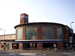
Chiswick Park tube station
London Underground station
Distance: Approx. 413 meters
Latitude and longitude: 51.49472222,-0.26777778
Chiswick Park is a London Underground station in the Acton Green district of Chiswick in West London. The station is served by the District line and is between Turnham Green and Acton Town stations. It is located at the junction of Bollo Lane and Acton Lane about 150 m north of Chiswick High Road (A315) and is in Travelcard Zone 3.

South Acton railway station (England)
London Overground station
Distance: Approx. 584 meters
Latitude and longitude: 51.4994,-0.2707
South Acton railway station is in the London Borough of Ealing in South Acton. It is on the North London line, and the station and all trains serving it are operated by London Overground. It is in Travelcard Zone 3.

Turnham Green
Human settlement in England
Distance: Approx. 600 meters
Latitude and longitude: 51.49194444,-0.26611111
Turnham Green is a public park on Chiswick High Road, Chiswick, London, and the neighbourhood and conservation area around it; historically, it was one of the four medieval villages in the Chiswick area, the others being Old Chiswick, Little Sutton, and Strand-on-the-Green. Christ Church, a neo-Gothic building designed by George Gilbert Scott and built in 1843, stands on the eastern half of the green. A war memorial stands on the eastern corner.

Gunnersbury Triangle
Nature reserve in Ealing and Hounslow, UK
Distance: Approx. 379 meters
Latitude and longitude: 51.49418889,-0.26827778
Gunnersbury Triangle is a 2.57-hectare (6.4-acre) local nature reserve in Chiswick, in the London boroughs of Ealing and Hounslow, immediately to the east of Gunnersbury. It was created in 1983 when, for the first time in Britain, a public inquiry ruled that a planned development of the land could not go ahead because of its value for nature. It opened as a nature reserve in 1985.

Old Pack Horse
Public house in Chiswick, London
Distance: Approx. 519 meters
Latitude and longitude: 51.4929,-0.2667
The Old Pack Horse is a Grade II listed public house in a prominent position on the corner of Chiswick High Road and Acton Lane in Chiswick, London.

Acton Works
London Underground depot
Distance: Approx. 489 meters
Latitude and longitude: 51.498,-0.278
Acton Works is a London Underground maintenance facility in West London, England. It is accessed from the District line and Piccadilly line tracks to the east of Acton Town station, and was opened in 1922. It was responsible for the overhaul of rolling stock, and gradually took on this role for more lines, until the formation of the London Passenger Transport Board in 1933, when all major overhauls of underground vehicles were carried out at the works.

Chiswick Park Footbridge
Bridge in Chiswick, England
Distance: Approx. 188 meters
Latitude and longitude: 51.495934,-0.272289
Chiswick Park Footbridge is a pedestrian bridge north of Gunnersbury Triangle Nature Reserve in Chiswick, London that connects Chiswick Business Park with Chiswick Park tube station.

Chiswick Empire
Former theatre and cinema in Chiswick, Hounslow, London, England
Distance: Approx. 561 meters
Latitude and longitude: 51.493,-0.266
The Chiswick Empire was a theatre facing Turnham Green in Chiswick that opened in 1912 and closed and was demolished in 1959. A venue for touring artists, some of the greatest names in drama, variety and music hall performed there including George Formby, Laurel and Hardy, Chico Marx, Peter Sellers and Liberace.
Cathedral of the Nativity of the Most Holy Mother of God and the Holy Royal Martyrs
Church in United Kingdom
Distance: Approx. 568 meters
Latitude and longitude: 51.4896,-0.276
The Cathedral of the Nativity of the Most Holy Mother of God and the Holy Royal Martyrs is a Russian Orthodox Church Outside Russia cathedral on Harvard Road in Chiswick, West London. The cathedral is dedicated to the Nativity of the Theotokos and of the Holy Royal Martyrs (the last Romanovs), who were murdered in July 1918 by Russian Bolsheviks. The Cathedral was opened in 1999, with a lesser consecration taking place in 2003, and a full consecration taking place in 2005.

Chiswick High Road
Street in the London Borough of Hounslow
Distance: Approx. 490 meters
Latitude and longitude: 51.49301,-0.26708
Chiswick High Road is the principal shopping and dining street of Chiswick, a district in the west of London. It was part of the main Roman road running west out of London, and remained the main road until the 1950s when the A4 was built across Chiswick. By the 19th century the road through the village of Turnham Green had grand houses beside it.
Weather in this IP's area
light rain
10 Celsius
7 Celsius
8 Celsius
11 Celsius
1014 hPa
75 %
1014 hPa
1013 hPa
10000 meters
4.63 m/s
250 degree
75 %
07:23:09
16:09:23
