Country:
Region:
City:
Latitude and Longitude:
Time Zone:
Postal Code:
IP information under different IP Channel
ip-api
Country
Region
City
ASN
Time Zone
ISP
Blacklist
Proxy
Latitude
Longitude
Postal
Route
IPinfo
Country
Region
City
ASN
Time Zone
ISP
Blacklist
Proxy
Latitude
Longitude
Postal
Route
MaxMind
Country
Region
City
ASN
Time Zone
ISP
Blacklist
Proxy
Latitude
Longitude
Postal
Route
Luminati
Country
ASN
Time Zone
Europe/Copenhagen
ISP
Telenor A/S
Latitude
Longitude
Postal
db-ip
Country
Region
City
ASN
Time Zone
ISP
Blacklist
Proxy
Latitude
Longitude
Postal
Route
ipdata
Country
Region
City
ASN
Time Zone
ISP
Blacklist
Proxy
Latitude
Longitude
Postal
Route
Popular places and events near this IP address

Herlev Municipality
Municipality in Hovedstaden, Denmark
Distance: Approx. 827 meters
Latitude and longitude: 55.726,12.434
Herlev Municipality (Danish: Herlev Kommune) is a municipality (Danish, kommune) in the northwestern suburbs of Copenhagen, Capital Region, Denmark. The municipality covers an area of 12 km², and has a total population of 29,876 (1. January 2024).
Herlev railway station
Commuter railway station in Greater Copenhagen, Denmark
Distance: Approx. 1524 meters
Latitude and longitude: 55.71888889,12.44361111
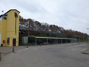
Herlev station is a suburban rail railway station serving the suburb of Herlev northwest of Copenhagen, Denmark. The station is located on the Frederikssund radial of Copenhagen's S-train network. It serves the central part of Herlev Municipality.
Skovlunde railway station
Commuter railway station in Greater Copenhagen, Denmark
Distance: Approx. 1149 meters
Latitude and longitude: 55.723,12.403
Skovlunde station is a commuter railway station serving the suburb of Skovlunde west of Copenhagen, Denmark. It is located on the Frederikssund radial of Copenhagen's S-train network.
Malmparken railway station
Commuter railway station in Greater Copenhagen, Denmark
Distance: Approx. 2207 meters
Latitude and longitude: 55.7246,12.386
Malmparken station is an S-train railway station serving the eastern part of the suburb of Ballerup northwest of Copenhagen, Denmark. The station is located on the Frederikssund radial of the S-train network in Copenhagen.

Herlev Hospital
Hospital in Capital Region, Denmark
Distance: Approx. 1617 meters
Latitude and longitude: 55.73138889,12.44361111
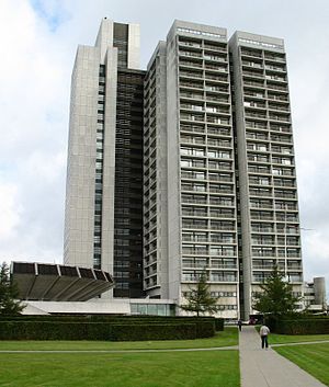
Herlev Hospital (former Danish: Amtssygehuset i Herlev) is a teaching hospital in Herlev, Denmark, close to Copenhagen. The building is 120 metres (390 ft) tall and has 25 floors. It was famous for being Denmark's tallest building, but was surpassed in 2022 by Light House in Aarhus.
Islev
Distance: Approx. 2383 meters
Latitude and longitude: 55.7056,12.44
Islev is a suburb, located approximately 10 km west of central Copenhagen, Denmark. The suburb consists of single-family detached houses and a commercial area. The suburb is connected to Copenhagen by the S-train.

GN Store Nord
Danish company
Distance: Approx. 2694 meters
Latitude and longitude: 55.73861111,12.38666667
GN Store Nord A/S is a Danish manufacturer of hearing aids (GN ReSound/GN Hearing), speakerphones, videobars and headsets (Jabra (GN Audio) and SteelSeries). GN Store Nord A/S is listed on NASDAQ OMX Copenhagen (ISIN code DK0010272632).

Herlev
Distance: Approx. 1026 meters
Latitude and longitude: 55.725,12.4375
Herlev is a suburb about 11 km northwest of Copenhagen city centre, bordering Rødovre to the south, Ballerup to the west and Gladsaxe to the north. It is the site of the municipal council of Herlev Municipality, Denmark.
Herlev IF
Danish football club
Distance: Approx. 1265 meters
Latitude and longitude: 55.73555556,12.42194444
Herlev Idrætsforening – Fodbold, also known as Herlev IF or HI-Fodbold, is a Danish football club located in the northwestern Copenhagen suburb, Herlev. The club is a member of the local association DBU Zealand under the Danish Football Association (DBU). Their home ground is Herlev Stadium.
Statens Pædagogiske Forsøgscenter
Distance: Approx. 2248 meters
Latitude and longitude: 55.70532778,12.43394722
National Innovative Centre (Danish: Statens Pædagogiske Forsøgscenter) was a state school located in Islev, Denmark. The school was established in 1964 by Danish education minister K. Helveg Petersen to develop teaching innovations, and share the results of their work with schools across Denmark. The school had to close in 2007 due to political conflicts.
Danish Bibliographic Centre
Danish company maintaining bibliographic information
Distance: Approx. 2413 meters
Latitude and longitude: 55.72279722,12.38279444
The Danish Bibliographic Centre (DBC A/S), based in Ballerup, Denmark, produces and supplies bibliographic data and information services — for example, the Danish DK5 system (DK5 Decimalklassedeling) derived from the Dewey Decimal Classification — to Danish libraries. DBC provides its data via DanBib, a joint bibliography for the entire Danish library system that includes a common reference database of national bibliography and holdings in all Danish public and research libraries. The system includes features to facilitate interlibrary loans, reuse of bibliographic data verification as well as links to relevant databases such as the Library of Congress and the ISSN system.
Sømosen
Bog in Denmark
Distance: Approx. 1386 meters
Latitude and longitude: 55.7328,12.40521944
Sømosen is a bog straddling the border between Ballerup (95%) and Herlev (5%) municipalities in the northwestern suburbs of Copenhagen, Denmark. It formed some time between 8,000 and 13,000 BC. The water from the bog drains into Harrestrup Å to the south through Sømose Å. It was protected in 1951. The protected area was increased from 20 to 23 hectares in 2006.
Weather in this IP's area
scattered clouds
10 Celsius
9 Celsius
9 Celsius
11 Celsius
1012 hPa
70 %
1012 hPa
1009 hPa
10000 meters
6.17 m/s
240 degree
48 %
07:33:19
18:20:19


