Country:
 Denmark
Region:
City:
Latitude and Longitude:
Time Zone:
Postal Code:
IP information under different IP Channel
ip-api
Country
Region
City
ASN
Time Zone
ISP
Blacklist
Proxy
Latitude
Longitude
Postal
Route
IPinfo
Country
Region
City
ASN
Time Zone
ISP
Blacklist
Proxy
Latitude
Longitude
Postal
Route
MaxMind
Country
Region
City
ASN
Time Zone
ISP
Blacklist
Proxy
Latitude
Longitude
Postal
Route
Luminati
Country
DKRegion
85
City
haslev
ASN
Time Zone
Europe/Copenhagen
ISP
Telenor A/S
Latitude
Longitude
Postal
db-ip
Country
Region
City
ASN
Time Zone
ISP
Blacklist
Proxy
Latitude
Longitude
Postal
Route
ipdata
Country
Region
City
ASN
Time Zone
ISP
Blacklist
Proxy
Latitude
Longitude
Postal
Route
Popular places and events near this IP address

Haslev
Town in Denmark
Distance: Approx. 946 meters
Latitude and longitude: 55.33333333,11.96666667
Haslev is a railway town in the southern part of the island of Zealand, Denmark, located about 60 km (37 mi) southwest of Copenhagen. It has a population of 12,488 (1 January 2024), and is the largest town in Faxe Municipality in Region Zealand. Haslev has six public schools: two boarding schools, a folk high school, a technical school, a college of education, and a sixth-form college.
Haslev Municipality
Distance: Approx. 946 meters
Latitude and longitude: 55.33333333,11.96666667
Until 1 January 2007, Haslev municipality was a Danish, kommune) in West Zealand County on the island of Zealand (Sjælland) in Denmark. The municipality covered an area of 133 km², and had a total population of 14,781 (2005). Its last mayor was Henrik Christensen, a member of the Venstre (Liberal Party) political party.
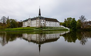
Bregentved
Danish manor house
Distance: Approx. 3331 meters
Latitude and longitude: 55.3074,12.007
Bregentved is a manor house located 3 km east of Haslev on the Danish island of Zealand. It has been owned by the Moltke family since the middle of the 18th century.

Vester Egede Church
Church
Distance: Approx. 7637 meters
Latitude and longitude: 55.26583333,11.96277778
Vester Egede Church (Danish: Vester Egede Kirke) is a Danish parish church in the Diocese of Roskilde, Faxe Municipality in Region Sjælland on the island of Zealand. It is located some 10 km (6.2 mi) due west of Faxe. Today's building dates from 1876 although there is evidence of an earlier church on the site, probably built during the Romanesque period.

Braaby Church
Church in Faxe Municipality, Denmark
Distance: Approx. 4648 meters
Latitude and longitude: 55.2975,11.94472222
Braaby Church (Danish: Bråby Kirke) is a Romanesque Danish church located in the Diocese of Roskilde, Faxe Municipality in Region Sjælland on the island of Zealand. There have been substantial Gothic additions to the original 12th-century building.

Freerslev Church
Church in Denmark
Distance: Approx. 2374 meters
Latitude and longitude: 55.32527778,12.01611111
Freerslev Church (Danish: Freerslev Kirke) is located in the Danish Diocese of Roskilde, Faxe Municipality in Region Sjælland on the island of Zealand. Parts of the original Romanesque church subsist today although there have been substantial Gothic additions. Primitive 14th-century frescos have been uncovered in the arch of an old window on the north wall.

Haslev Church
Church
Distance: Approx. 1636 meters
Latitude and longitude: 55.32305556,11.96361111
Haslev Church (Danish: Haslev Kirke) is a church located in the town of Haslev, Diocese of Roskilde, Faxe Municipality in Region Sjælland on the Danish island of Zealand. The oldest parts of the church were built in the 12th century but today's structure is the result of its rebuilding in 1916.

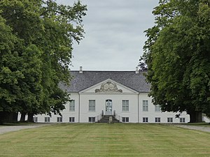
Gisselfeld
Distance: Approx. 5026 meters
Latitude and longitude: 55.28888889,11.97055556
Gisselfeld, a former monastery, is Denmark's fifth-largest estate. Located between Haslev and Næstved, it extends into several municipalities but the main building is located in Braaby Parish in Faxe Municipality. The estate measures 3,850 hectares, including Hesede, Edelesminde, Brødebæk and Gødstrupgård, of which 2,400 hectares is forest.

Algestrup
Town in Region Zealand, Denmark
Distance: Approx. 7807 meters
Latitude and longitude: 55.37611111,12.07972222
Algestrup is a small railway town with a population of 933 (1 January 2024). The town is located in the southern part of Køge Municipality in Region Zealand, Denmark, just north of the boundary between Køge and Faxe Municipality, on the Little South railway line between Køge and Haslev. In spite of the fact that a railway station is located in the southern part of Algestrup, the station is not named Algestrup but Tureby, named after two manor houses Turebylille and Turebyholm in Faxe Municipality about 2 and 4 kilometres south of the station.

Dalby, Faxe Municipality
Town in Faxe Municipality, Denmark
Distance: Approx. 5486 meters
Latitude and longitude: 55.31333333,12.06055556
Dalby is a town in Faxe Municipality, in Region Zealand, Denmark. Sønder Dalby Church stands in the centre of the town. Dalby Hotel is located on the southwestern outskirts of the town at the road between Køge and Vordingborg.
Turebyholm
Manor house near Copenhagen, Denmark
Distance: Approx. 7212 meters
Latitude and longitude: 55.34746111,12.09288056
Turebyholm is a manor house in Faxe Municipality, some fifty kilometres southwest of Copenhagen, Denmark. It was acquired by Adam Gottlob Moltke in 1746 and has remained in the hands of the Moltke family to the present day. It was part of the Countship of Bregentved from 1756 to 1920 and still shares its ownership with the Bregentved estate.

Haslev railway station
Railway station in Southern Zealand, Denmark
Distance: Approx. 1390 meters
Latitude and longitude: 55.329375,11.96094444
Haslev railway station is a railway station serving the large railway town of Haslev in southern Zealand, Denmark. Haslev station is located on the Little South branch line from Køge to Næstved. The station opened as part of the original Zealand South Line in 1870.
Weather in this IP's area
scattered clouds
10 Celsius
9 Celsius
9 Celsius
11 Celsius
1013 hPa
70 %
1013 hPa
1008 hPa
10000 meters
5.67 m/s
10.27 m/s
254 degree
35 %
07:34:31
18:22:38