130.156.183.227 - IP Lookup: Free IP Address Lookup, Postal Code Lookup, IP Location Lookup, IP ASN, Public IP
Country:
 USA
USARegion:
City:
Location:
Time Zone:
Postal Code:
ISP:
ASN:
language:
User-Agent:
Proxy IP:
Blacklist:
IP information under different IP Channel
ip-api
Country
Region
City
ASN
Time Zone
ISP
Blacklist
Proxy
Latitude
Longitude
Postal
Route
db-ip
Country
Region
City
ASN
Time Zone
ISP
Blacklist
Proxy
Latitude
Longitude
Postal
Route
IPinfo
Country
Region
City
ASN
Time Zone
ISP
Blacklist
Proxy
Latitude
Longitude
Postal
Route
IP2Location
130.156.183.227Country
usRegion
new jersey
City
newark
Time Zone
America/New_York
ISP
Language
User-Agent
Latitude
Longitude
Postal
ipdata
Country
Region
City
ASN
Time Zone
ISP
Blacklist
Proxy
Latitude
Longitude
Postal
Route
Popular places and events near this IP address

Newark, New Jersey
Most populous city in New Jersey, United States
Distance: Approx. 263 meters
Latitude and longitude: 40.73555556,-74.17222222
Newark ( NEW-ərk, locally [nʊək]) is the most populous city in the U.S. state of New Jersey, the county seat of Essex County, and a principal city of the New York metropolitan area. As of the 2020 census, the city's population was 311,549. The Population Estimates Program calculated a population of 304,960 for 2023, making it the 66th-most populous municipality in the nation.
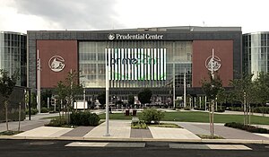
Prudential Center
Multipurpose arena in Newark, New Jersey
Distance: Approx. 203 meters
Latitude and longitude: 40.73361111,-74.17111111
Prudential Center is a multipurpose indoor arena in the central business district of Newark, New Jersey, United States. Opened in 2007, it is the home of the New Jersey Devils of the National Hockey League (NHL), the New York Sirens of the Professional Women's Hockey League (PWHL), and the men's basketball program of Seton Hall University. By 2023, it was among the top five concert venues worldwide by earnings.
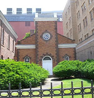
Old First Presbyterian Church (Newark, New Jersey)
Historic church in New Jersey, United States
Distance: Approx. 120 meters
Latitude and longitude: 40.73416667,-74.1725
The Old First Presbyterian Church, also known as First Presbyterian Church and Cemetery, is a church in Newark, Essex County, New Jersey, United States. The church was listed on the National Register of Historic Places in 1972. The grounds, located in the Four Corners Historic District, includes an old burial ground.

Grant USA Tower
Proposed 121-story skyscraper planned for Newark, New Jersey
Distance: Approx. 128 meters
Latitude and longitude: 40.732755,-74.172242
The Grant USA Tower was a proposed 121-story skyscraper planned for Newark, New Jersey by developer Harry Grant. Harry Grant was an Iraqi-born developer who was based out of New Jersey who financed the gold dome on top of Newark City Hall The tower was to be located over the Central Railroad of New Jersey's old Broad Street station, near Broad and Lafayette Street. In 2007, the incomplete Renaissance Mall was torn down to build the Prudential Center.
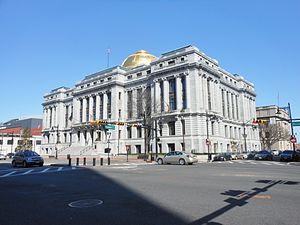
Newark City Hall
United States historic place
Distance: Approx. 201 meters
Latitude and longitude: 40.73166667,-74.17416667
Newark City Hall is located at Government Center in Newark in Essex County, New Jersey. The building was built in 1902 and was added to the National Register of Historic Places on February 17, 1978.

First National State Bank Building
United States historic place
Distance: Approx. 182 meters
Latitude and longitude: 40.73472222,-74.17222222
The First National State Bank Building, also known as the Indigo Residence, is located at 810 Broad Street in Newark, New Jersey, United States. The building was designed by Cass Gilbert and was built in 1912. The building stands 165 ft (50 m) and is twelve stories tall with a steel frame and with a facade of applied masonry.

Four Corners (Newark)
Historic district in Essex County, New Jersey, US
Distance: Approx. 265 meters
Latitude and longitude: 40.73556,-74.172172
The Four Corners Historic District is the intersection of Broad and Market Streets in Newark, New Jersey. It is the site of the city's earliest settlement and the heart of Downtown Newark that at one time was considered the busiest intersection in the United States. The area that radiates twenty-two square blocks from the crossroads is a state and federal historic district.

Newark Collegiate Academy
Charter school in Newark, New Jersey, United States
Distance: Approx. 150 meters
Latitude and longitude: 40.732333,-74.174577
Newark Collegiate Academy (NCA) is a four-year charter public high school located in Newark in Essex County, in the U.S. state of New Jersey, operating as part of the TEAM Academy Charter School network of charter schools in Newark run by the Knowledge Is Power Program (KIPP) which serves students in kindergarten through twelfth grade. NCA opened in August 2007 with plans to ultimately serve over 570 students, mostly matriculating from TEAM's middle schools, Rise and TEAM Academies. As of the 2022–23 school year, the school had an enrollment of 6,096 students and 270.0 classroom teachers (on an FTE basis), for a student–teacher ratio of 22.6:1.
McDonald's Gospelfest
Annual music festival
Distance: Approx. 104 meters
Latitude and longitude: 40.7332,-74.1723
The McDonald's Gospelfest is an annual gospel music festival, talent competition, and fundraiser in Newark, New Jersey.
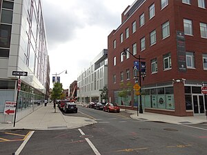
Teachers Village, Newark
Populated place in Essex County, New Jersey, US
Distance: Approx. 135 meters
Latitude and longitude: 40.733641,-74.175069
Teachers Village is a neighborhood centered around Halsey Street in Newark, New Jersey. It is located in Downtown Newark in southwest quadrant of the Four Corners Historic District, south of Market Street (SoMa) in the Central Ward between the Prudential Center and Springfield/Belmont. Teachers Village was originally developed by RBH and was designed by Newark native Richard Meier.
Statue of George Floyd
2021 statue in Newark, New Jersey, United States
Distance: Approx. 183 meters
Latitude and longitude: 40.7318,-74.174
A bronze statue of George Floyd (1973–2020), an African-American man who was murdered by police in Minneapolis, was completed by Stanley Watts and unveiled in 2021. It is situated outside Newark, New Jersey's City Hall in Government Center.

Newark Broad Street station (Central Railroad of New Jersey)
Former railway station in Newark, New Jersey, US
Distance: Approx. 95 meters
Latitude and longitude: 40.73395,-74.17263889
Newark Broad Street station was a railway terminal in Newark, New Jersey at the western end of the Newark and New York Branch of the Central Railroad of New Jersey. The station was located on Broad Street, near Four Corners. It was approximately 2,500 feet (760 m) west of the Pennsylvania Railroad's Newark Penn Station and 1 mile (1.6 km) south of the Delaware, Lackawanna and Western Railroad's Newark Broad Street station.
Weather in this IP's area
scattered clouds
-2 Celsius
-6 Celsius
-4 Celsius
-1 Celsius
1025 hPa
45 %
1025 hPa
1020 hPa
10000 meters
3.09 m/s
310 degree
40 %