130.156.136.250 - IP Lookup: Free IP Address Lookup, Postal Code Lookup, IP Location Lookup, IP ASN, Public IP
Country:
 USA
USARegion:
City:
Location:
Time Zone:
Postal Code:
ISP:
ASN:
language:
User-Agent:
Proxy IP:
Blacklist:
IP information under different IP Channel
ip-api
Country
Region
City
ASN
Time Zone
ISP
Blacklist
Proxy
Latitude
Longitude
Postal
Route
db-ip
Country
Region
City
ASN
Time Zone
ISP
Blacklist
Proxy
Latitude
Longitude
Postal
Route
IPinfo
Country
Region
City
ASN
Time Zone
ISP
Blacklist
Proxy
Latitude
Longitude
Postal
Route
IP2Location
130.156.136.250Country
usRegion
new jersey
City
lawrenceville
Time Zone
America/New_York
ISP
Language
User-Agent
Latitude
Longitude
Postal
ipdata
Country
Region
City
ASN
Time Zone
ISP
Blacklist
Proxy
Latitude
Longitude
Postal
Route
Popular places and events near this IP address
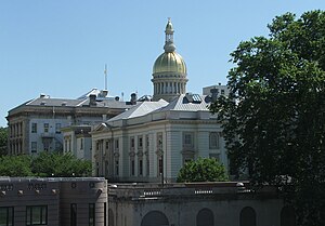
Mercer County, New Jersey
County in New Jersey, United States
Distance: Approx. 1608 meters
Latitude and longitude: 40.28,-74.7
Mercer County is a county located in the U.S. state of New Jersey. Its county seat is Trenton, also the state capital, prompting its nickname The Capital County. Mercer County alone constitutes the Trenton–Princeton metropolitan statistical area and is considered part of the New York combined statistical area by the U.S. Census Bureau, but also directly borders the Philadelphia metropolitan area and is included within the Federal Communications Commission's Philadelphia Designated Media Market Area.

Lawrence High School (New Jersey)
High school in Mercer County, New Jersey, US
Distance: Approx. 2951 meters
Latitude and longitude: 40.264214,-74.730573
Lawrence High School (LHS) is a four-year comprehensive public high school in Lawrence Township, in Mercer County, in the U.S. state of New Jersey, serving students in ninth through twelfth grades as the lone secondary school of the Lawrence Township Public Schools. The school is located in the Lawrenceville section of the township. The school has been accredited by the Middle States Association of Colleges and Schools Commission on Elementary and Secondary Schools since 1992.

WPRB
Radio station at Princeton University
Distance: Approx. 2070 meters
Latitude and longitude: 40.28288889,-74.686
WPRB (103.3 MHz) is an FM radio station licensed to Princeton, New Jersey, and owned by Princeton Broadcasting Service, Inc. It broadcasts a freeform radio format, including shoegaze, slowcore, noise music, harsh noise wall, plunderphonics, illbient, jazz, electronic, folk, reggae, ska, metal, world, soul, rap, blues, and rock. While the station is non-profit, it is licensed as a commercial radio station.
Lawrence Township Public Schools
School district in Mercer County, New Jersey, US
Distance: Approx. 2739 meters
Latitude and longitude: 40.266668,-74.728126
The Lawrence Township Public Schools is a comprehensive community public school district that serves students in pre-kindergarten through twelfth grade from Lawrence Township, in Mercer County, in the U.S. state of New Jersey. As of the 2020–21 school year, the district, comprising seven schools, had an enrollment of 3,707 students and NA classroom teachers (on an FTE basis), for a student–teacher ratio of NA:1. The district is classified by the New Jersey Department of Education as being in District Factor Group "GH", the third-highest of eight groupings.
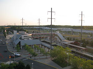
Hamilton station (NJ Transit)
NJ Transit rail station
Distance: Approx. 1363 meters
Latitude and longitude: 40.25527778,-74.70388889
Hamilton station is an NJ Transit station on the Northeast Corridor Line, in Hamilton Township, Mercer County, New Jersey, United States. Also at this station is the NJ Transit Hamilton Township bus garage. The station is at 600 Sloan Avenue, off exit 65B of Interstate 295.

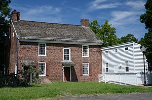
Port Mercer Canal House
Historic house in New Jersey, United States
Distance: Approx. 2310 meters
Latitude and longitude: 40.28665,-74.69588
The Port Mercer Canal House is a historic house along the Delaware and Raritan Canal. It is located at 4278 Quakerbridge Road in the Port Mercer section of Lawrence Township, Mercer County, New Jersey, United States, near the border of West Windsor Township and Princeton, New Jersey. The house was built in the 1830s as housing for bridgetender and his family.

Quaker Bridge Mall
Shopping mall in Mercer County, New Jersey
Distance: Approx. 2999 meters
Latitude and longitude: 40.2906,-74.6818
Quaker Bridge Mall is a two-level super-regional mall located in the Clarksville section of Lawrence Township, Mercer County, New Jersey. As of 2022, the mall features the traditional anchors Macy's and JCPenney. The mall currently features prominent specialty stores Coach New York, White House Black Market, and Ann Taylor.

Colonial Lake
Reservoir in Mercer County, New Jersey
Distance: Approx. 2658 meters
Latitude and longitude: 40.25585278,-74.72428611
Colonial Lake is a 25-acre (10 ha) man-made lake along the Shabakunk Creek in Lawrence Township, Mercer County, New Jersey, United States. It is located on Business Route 1 across from the Lawrence Shopping Center. The lake was created when an earthen dam was constructed across the Shabakunk in 1924 by local housing developers interested in providing recreation opportunities for a nearby development, which became known as Colonial Lakelands.

Shabakunk Creek
River in New Jersey, United States
Distance: Approx. 2695 meters
Latitude and longitude: 40.24944444,-74.71916667
The Shabakunk Creek is a tributary of the Assunpink Creek in Mercer County, New Jersey, United States. Via the Assunpink, its water ultimately flows into the Delaware River. The name Shabakunk is from the Lenape word meaning "shore land".
Baker–Brearley House
United States historic place
Distance: Approx. 2990 meters
Latitude and longitude: 40.2925,-74.70080556
The Brearley House is a historic Georgian house built in 1761 in Lawrenceville, New Jersey. It was added to the National Register of Historic Places in 1979. Lawrence Township, which owns the property, leased it to the Lawrence Historical Society in 2000.

Thomas Maddock's Sons Company
United States historic place
Distance: Approx. 1480 meters
Latitude and longitude: 40.25541667,-74.70661111
Thomas Maddock's Sons Company was founded by Thomas Maddock.

Van Nest Refuge Wildlife Management Area
Distance: Approx. 2635 meters
Latitude and longitude: 40.267357,-74.664934
Van Nest Refuge Wildlife Management Area is a 98-acre (40 ha) wildlife management area in Hamilton Township, Mercer County, New Jersey, United States.
Weather in this IP's area
clear sky
-4 Celsius
-4 Celsius
-5 Celsius
-3 Celsius
1026 hPa
58 %
1026 hPa
1021 hPa
10000 meters