Country:
 New Zealand
Region:
City:
Latitude and Longitude:
Time Zone:
Postal Code:
IP information under different IP Channel
ip-api
Country
Region
City
ASN
Time Zone
ISP
Blacklist
Proxy
Latitude
Longitude
Postal
Route
IPinfo
Country
Region
City
ASN
Time Zone
ISP
Blacklist
Proxy
Latitude
Longitude
Postal
Route
MaxMind
Country
Region
City
ASN
Time Zone
ISP
Blacklist
Proxy
Latitude
Longitude
Postal
Route
Luminati
Country
NZRegion
mwt
City
palmerstonnorth
ASN
Time Zone
Pacific/Auckland
ISP
Massey University
Latitude
Longitude
Postal
db-ip
Country
Region
City
ASN
Time Zone
ISP
Blacklist
Proxy
Latitude
Longitude
Postal
Route
ipdata
Country
Region
City
ASN
Time Zone
ISP
Blacklist
Proxy
Latitude
Longitude
Postal
Route
Popular places and events near this IP address

Freyberg High School
State co-educational school in Palmerston North, Manawatū-Whanganui
Distance: Approx. 2021 meters
Latitude and longitude: -40.338,175.6275
Freyberg High School (Māori: Te Kura o Te Pou Hōia) is a state co-educational secondary school located in the suburb of Roslyn in Palmerston North, New Zealand. Freyberg High School is named for hero of both world wars, Lord Bernard Freyberg, who is known for his service in the Gallipoli Campaign during the First World War and later service commanding the New Zealand Expeditionary Force during the Second World War. Freyberg served as the 7th Governor-General of New Zealand from 1946 to 1952.

Roslyn, Palmerston North
Suburb of Palmerston North
Distance: Approx. 1733 meters
Latitude and longitude: -40.33588056,175.62974722
Roslyn is a suburb in the city of Palmerston North, Manawatū-Whanganui, New Zealand. It is located 3 kilometres (1.9 mi) north-east of the central city and bounded on the north by the North Island Main Trunk Railway (Milson), on the east by Palmerston North-Gisborne Railway (Kelvin Grove), the south by Main Street East (Terrace End) and the west by Ruahine Street (Palmerston North Hospital Area). Roslyn is also located 2.1 km SE from Palmerston North International Airport.
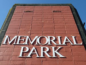
Memorial Park, Palmerston North
Sports venue in Palmerston North, New Zealand
Distance: Approx. 2330 meters
Latitude and longitude: -40.3464,175.6346
Memorial Park is a multi-use stadium in Palmerston North, New Zealand. It is currently used mostly for football matches and was the home stadium of YoungHeart Manawatu before they disbanded. The stadium has a capacity of 8,000 people.

Kelvin Grove, Palmerston North
Suburb of Palmerston North
Distance: Approx. 904 meters
Latitude and longitude: -40.33,175.63694444
Kelvin Grove is a suburb of Palmerston North on New Zealand's North Island. It is bounded on the north by the North Island Main Trunk railway, Manawatū District and Milson, on the west by Palmerston North–Gisborne Line and Roslyn, the south by the Manawatū River, and the east by James Line and Whakarongo. It was identified as one of New Zealand's fastest growth suburbs in November 2016.

Terrace End
Suburb of Palmerston North
Distance: Approx. 2549 meters
Latitude and longitude: -40.34916667,175.63638889
Terrace End is a suburb of Palmerston North, New Zealand. Terrace End is located in the south east part of the city on a bend in the Manawatu River. It is bounded to the north by Main Street East, Roslyn and Kelvin Grove.
Milson, New Zealand
Suburb of Palmerston North
Distance: Approx. 2663 meters
Latitude and longitude: -40.33333333,175.61666667
Milson is a suburb of Palmerston North, Manawatū-Whanganui, New Zealand. The suburb is located to the north of the city, beyond the North Island Main Trunk Rail. Milson is mostly a residential suburb with a population of 6,246 (2018).

Whakarongo
Suburb of Palmerston North
Distance: Approx. 1763 meters
Latitude and longitude: -40.33333333,175.66666667
Whakarongo is a suburb of Palmerston North, New Zealand, between the city and Ashhurst. It is mainly rural, and features many vegetable gardens. Whakarongo was originally named Stoney Creek and along with neighbouring Kelvin Grove was part of the Stoney Creek Scandinavian and Roadmen's Block.
Ross Intermediate School
School in Palmerston North, New Zealand
Distance: Approx. 2163 meters
Latitude and longitude: -40.338,175.6255
Ross Intermediate is a state co-educational intermediate school located in the Palmerston North, New Zealand suburb of Roslyn. It is the first school in New Zealand to have its own television station and laptop programme. The school television station has since been discontinued.
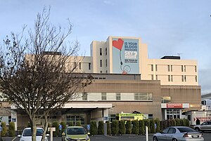
Palmerston North Hospital
Hospital in Manawatū-Whanganui, New Zealand
Distance: Approx. 2585 meters
Latitude and longitude: -40.3387,175.6203
Palmerston North Regional Hospital is the primary public hospital in Palmerston North, New Zealand. Located at the northern end of Ruahine Street, it is approximately 2 km (1.2 mi) northeast of The Square. The hospital is operated by the MidCentral District Health Board, which serves Palmerston North and the surrounding districts of Manawatū, Tararua and Horowhenua districts.
Cornerstone Christian School, Palmerston North
State-integrated school in New Zealand
Distance: Approx. 452 meters
Latitude and longitude: -40.3311,175.6503
Cornerstone Christian School is an integrated co-educational Area School (combined Primary and Secondary) for Years 1–13 in the city of Palmerston North, New Zealand. The school is divided by an administrative block between the junior and senior areas, after the senior area the newly installed intermediate block is situated.

Whakarongo railway station
Former railway station in New Zealand
Distance: Approx. 2288 meters
Latitude and longitude: -40.324172,175.673731
The Whakarongo Railway Station was a passenger rail station on the Palmerston North to Gisborne line, in the suburb of Whakarongo in the north of Palmerston North. The station was situated between the Terrace End Station and Ashhurst Station. The station opened on 9 March 1891.

Terrace End Cemetery
Cemetery in Palmerston North, New Zealand
Distance: Approx. 1756 meters
Latitude and longitude: -40.34305556,175.64194444
Terrace End Cemetery is the oldest cemetery in Palmerston North, New Zealand. Almost 10,000 people have been buried in the cemetery since Rangitāne gifted the land to the fledgling Palmerston North settlement in 1875. Plots are now closed, but the descendants of those buried at the cemetery can be buried with their relatives.
Weather in this IP's area
overcast clouds
10 Celsius
10 Celsius
10 Celsius
10 Celsius
1026 hPa
92 %
1026 hPa
1020 hPa
10000 meters
0.94 m/s
1.02 m/s
13 degree
93 %
06:23:29
19:41:00