130.108.73.84 - IP Lookup: Free IP Address Lookup, Postal Code Lookup, IP Location Lookup, IP ASN, Public IP
Country:
Region:
City:
Location:
Time Zone:
Postal Code:
IP information under different IP Channel
ip-api
Country
Region
City
ASN
Time Zone
ISP
Blacklist
Proxy
Latitude
Longitude
Postal
Route
Luminati
Country
Region
oh
City
dayton
ASN
Time Zone
America/New_York
ISP
Cloudflare London, LLC
Latitude
Longitude
Postal
IPinfo
Country
Region
City
ASN
Time Zone
ISP
Blacklist
Proxy
Latitude
Longitude
Postal
Route
IP2Location
130.108.73.84Country
Region
ohio
City
dayton
Time Zone
America/New_York
ISP
Language
User-Agent
Latitude
Longitude
Postal
db-ip
Country
Region
City
ASN
Time Zone
ISP
Blacklist
Proxy
Latitude
Longitude
Postal
Route
ipdata
Country
Region
City
ASN
Time Zone
ISP
Blacklist
Proxy
Latitude
Longitude
Postal
Route
Popular places and events near this IP address
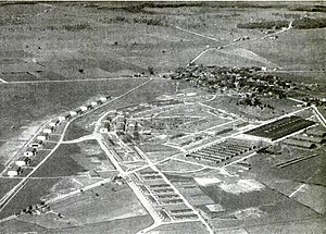
Wilbur Wright Field
WWI era military airfield in Ohio, U.S.
Distance: Approx. 2259 meters
Latitude and longitude: 39.77944444,-84.10444444
Wilbur Wright Field was a military installation and an airfield used as a World War I pilot, mechanic, and armorer training facility and, under different designations, conducted United States Army Air Corps and Air Forces flight testing. Located near Riverside, Ohio, the site is officially "Area B" of Wright-Patterson Air Force Base and includes the National Museum of the United States Air Force built on the airfield.

National Museum of the United States Air Force
Military and aviation museum in Dayton, Ohio, US
Distance: Approx. 2811 meters
Latitude and longitude: 39.78138889,-84.11055556
The National Museum of the United States Air Force (formerly the United States Air Force Museum) is the official museum of the United States Air Force located at Wright-Patterson Air Force Base, six miles (9.7 km) northeast of Dayton, Ohio. The NMUSAF is the oldest and largest military aviation museum in the world, with more than 360 aircraft and missiles on display. The museum is a central component of the National Aviation Heritage Area.

The Mall at Fairfield Commons
Shopping mall in Beavercreek, Ohio
Distance: Approx. 2330 meters
Latitude and longitude: 39.767084,-84.055967
The Mall at Fairfield Commons, often referred to as the Fairfield Mall, is a shopping mall in Beavercreek, Ohio, United States, a suburb of Dayton. The mall was opened in 1993 and has two floors. The anchor stores are Macy's, J. C. Penney, Dick's Sporting Goods, Round 1 Entertainment, and Morris Home Furniture.

Air Force Institute of Technology
U.S. military graduate school in near Dayton, Ohio
Distance: Approx. 1737 meters
Latitude and longitude: 39.783,-84.083
The Air Force Institute of Technology (AFIT) is a postgraduate institution and provider of professional and continuing education for the United States Armed Forces and is part of the United States Air Force. It is in Ohio at Wright-Patterson Air Force Base, near Dayton. AFIT is a component of the Air University and Air Education and Training Command.
National Aviation Hall of Fame
Aviation museum, annual awards ceremony, learning and research center
Distance: Approx. 2671 meters
Latitude and longitude: 39.78293889,-84.10698611
The National Aviation Hall of Fame (NAHF) is a museum, annual awards ceremony and learning and research center that was founded in 1962 as an Ohio non-profit corporation in Dayton, Ohio, United States, known as the "Birthplace of Aviation" with its connection to the Wright brothers. In 2017, the annual induction was held in Fort Worth, Texas, as the organization began rotating the ceremony among various cities.

Bockscar
Airplane that dropped the second atomic bomb
Distance: Approx. 2732 meters
Latitude and longitude: 39.781976,-84.108892
Bockscar, sometimes called Bock's Car, is the United States Army Air Forces B-29 bomber that dropped a Fat Man nuclear weapon over the Japanese city of Nagasaki during World War II in the second – and most recent – nuclear attack in history. One of 15 Silverplate B-29s used by the 509th, Bockscar was built at the Glenn L. Martin Aircraft Plant at Bellevue, Nebraska, at what is now Offutt Air Force Base, and delivered to the United States Army Air Forces on 19 March 1945. It was assigned to the 393rd Bombardment Squadron, 509th Composite Group to Wendover Army Air Field, Utah, in April and was named after captain Frederick C. Bock.
Boonshoft School of Medicine
Medical school of Wright State University
Distance: Approx. 2177 meters
Latitude and longitude: 39.777935,-84.06176
The Boonshoft School of Medicine, also known as Wright State University School of Medicine, is an accredited medical school at Wright State University. It is located in Dayton, Ohio, United States and serves the Miami Valley region of southwestern Ohio. The school was renamed in 2005 in honor of Oscar Boonshoft who gifted $28.5 million to further medical education, research, and scholarship.

Soin Medical Center
Hospital in Ohio, United States
Distance: Approx. 1819 meters
Latitude and longitude: 39.77111111,-84.0625
Soin Medical Center is a full-service hospital located in Beavercreek, Ohio, United States, next to the Mall at Fairfield Commons. It is part of the Kettering Health network. The medical center is accredited by the American Osteopathic Association's Healthcare Facilities Accreditation Program.

Wright-Patterson Air Force Base Mound
Archaeological site in Ohio, United States
Distance: Approx. 2157 meters
Latitude and longitude: 39.78675,-84.08444444
The Wright-Patterson Air Force Base Mound, designated 33GR31, is a Native American mound near the city of Dayton in Greene County, Ohio, United States. Named for its location on an Air Force facility, Wright-Patterson Air Force Base, the mound is an archaeological site. The mound lies on a bluff sitting above generally flat terrain; it measures 86 feet (26 m) in diameter and slightly more than 8 feet (2.4 m) tall.

Fairfield Aviation General Supply Depot
Military facility in Ohio, United States
Distance: Approx. 2735 meters
Latitude and longitude: 39.78111111,-84.10972222
The Fairfield Aviation General Supply Depot is a former Aviation Section, U.S. Signal Corps military facility, located adjacent to Wilbur Wright Field in Riverside, Ohio.
New Germany, Ohio
Unincorporated community in Ohio, U.S.
Distance: Approx. 860 meters
Latitude and longitude: 39.77472222,-84.08
New Germany is mostly a neighborhood of Beavercreek, in Greene County, Ohio, United States, with small adjacent areas in unincorporated Beavercreek Township.
McGuffy's
Distance: Approx. 2608 meters
Latitude and longitude: 39.75788889,-84.11105556
McGuffy's, also known as McGuffy's House of Draft and McGuffy's House of Rock, was a 550-capacity music venue located at 5418 Burkhardt Road in Dayton, Ohio. The club opened in 1981 and closed in 2014. It hosted notable bands such as Quiet Riot, Saxon, UFO, Blue Öyster Cult, Dio and Dream Theater.
Weather in this IP's area
broken clouds
7 Celsius
3 Celsius
6 Celsius
8 Celsius
1024 hPa
51 %
1024 hPa
987 hPa
10000 meters
7.2 m/s
12.86 m/s
190 degree
75 %
