Country:
 Mexico
Region:
City:
Latitude and Longitude:
Time Zone:
Postal Code:
IP information under different IP Channel
ip-api
Country
Region
City
ASN
Time Zone
ISP
Blacklist
Proxy
Latitude
Longitude
Postal
Route
IPinfo
Country
Region
City
ASN
Time Zone
ISP
Blacklist
Proxy
Latitude
Longitude
Postal
Route
MaxMind
Country
Region
City
ASN
Time Zone
ISP
Blacklist
Proxy
Latitude
Longitude
Postal
Route
Luminati
Country
MXRegion
cmx
City
mexicocity
ASN
Time Zone
America/Mexico_City
ISP
SPACEX-STARLINK
Latitude
Longitude
Postal
db-ip
Country
Region
City
ASN
Time Zone
ISP
Blacklist
Proxy
Latitude
Longitude
Postal
Route
ipdata
Country
Region
City
ASN
Time Zone
ISP
Blacklist
Proxy
Latitude
Longitude
Postal
Route
Popular places and events near this IP address

Zapata metro station
Mexico City metro station
Distance: Approx. 1263 meters
Latitude and longitude: 19.370952,-99.164937
Zapata is a station on Line 3 and Line 12 of the Mexico City Metro, in the Benito Juárez borough of Mexico City. The station logo depicts Emiliano Zapata, a national hero from the Mexican Revolution of 1910–1921. The station serves the Colonia Del Valle and Santa Cruz Atoyac neighborhoods in Benito Juárez.

Estadio Ciudad de los Deportes
Sports stadium in Ciudad de los Deportes, Mexico City
Distance: Approx. 713 meters
Latitude and longitude: 19.38338889,-99.178225
Estadio Ciudad de los Deportes (English: “Sports City Stadium”; formerly Estadio Azul) is a 33,000-seat stadium located in Ciudad de los Deportes, Mexico City. This sports facility is used for association football matches and for American football as well. The Tazón México has been played at the stadium.

Plaza de Toros México
Building in Mexico City, Mexico
Distance: Approx. 713 meters
Latitude and longitude: 19.38338889,-99.178225
The Plaza de toros México, situated in Mexico City, is the world's largest bullring. This 41,262-seat facility is usually dedicated to bullfighting, but many boxing matches have been held there as well, including Julio César Chávez's third and final bout with Frankie Randall on May 22, 2004. The Plaza México replaced the former Toreo de la Condesa bullring in the Condesa neighborhood that was overwhelmed by the rapid growth of population in the capital.
Secretariat of Energy (Mexico)
Distance: Approx. 969 meters
Latitude and longitude: 19.387,-99.174
The Secretariat of Energy (Spanish: Secretaría de Energia) is the government department in charge of production and regulation of energy in Mexico, this secretary is a member of the Executive Cabinet. The current Secretariat of Energy under Andrés Manuel López Obrador (AMLO) MORENA is Rocío Nahle García.
Panamerican University
Mexican university in Mexico City
Distance: Approx. 1089 meters
Latitude and longitude: 19.3746,-99.1837
Universidad Panamericana (English: Panamerican University), commonly known as UP, is a private research, Roman Catholic university founded in Mexico City. It has four campuses: the main Mixcoac campus in the Benito Juarez borough of south-western Mexico City, founded in 1968; the Guadalajara campus established in 1981; the Aguascalientes campus established in 1989; and Campus Santa Fe, also in Mexico City, founded in 2011. One of the most prestigious universities in Mexico, it on is currently ranked 4th best university in Mexico by QS World University Rankings and has a 4 star rating.

Parque Hundido
Park in Mexico City
Distance: Approx. 504 meters
Latitude and longitude: 19.37805556,-99.17888889
Parque Hundido (official name is Parque Luis G. Urbina) is an urban park located in Benito Juárez, Mexico City.
Galerías Insurgentes
Building in Mexico City, Mexico
Distance: Approx. 971 meters
Latitude and longitude: 19.3708397,-99.1788973
Galerías Insurgentes, full name Centro Comercial Galerías Insurgentes, is a shopping mall on Insurgentes Sur Avenue at Parroquia in the Actipan neighborhood of Colonia Del Valle, Mexico City.

Federal Telecommunications Institute
Mexican telecommunications regulator
Distance: Approx. 481 meters
Latitude and longitude: 19.3818488,-99.1767167
The Federal Telecommunications Institute (Spanish: Instituto Federal de Telecomunicaciones; abbreviated as IFT and incorrectly referred to as IFETEL, Tzeltal: Snaul jtsob a’telelil Sk’asesojibal k’op Ayejetik ta ch’ajantak’inetik, Q’eqchi: Rochochil li Xna’ li K´iila Puktesib´aal, Ixcatlán Mazatec: Ndo̱bo̱a̱ Xtitjón xi chji̱a̱ni ni xi tsꞌentsójó eén, Kiliwa: Pakutiy tuchatu te-e ñam pjkai, Chuj: Instituto Yik yajal k’en Alumel ab’ix) is an independent government agency of Mexico charged with the regulation of telecommunications and broadcasting services. It was formed on September 10, 2013, as part of larger reforms to Mexican telecom regulations, and replaced the Federal Telecommunications Commission (Cofetel). The current President of the IFT is Gabriel Oswaldo Contreras Saldívar.

Insurgentes Sur metro station
Mexico City metro station
Distance: Approx. 718 meters
Latitude and longitude: 19.373581,-99.178762
Insurgentes Sur is a station on Line 12 of the Mexico City Metro. The station is located between Mixcoac and Hospital 20 de Noviembre. It was opened on 30 October 2012 as part of the first stretch of Line 12 between Mixcoac and Tláhuac.
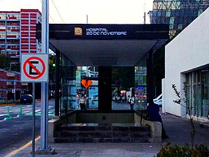
Hospital 20 de Noviembre metro station
Mexico City metro station
Distance: Approx. 769 meters
Latitude and longitude: 19.372042,-99.171005
Hospital 20 de Noviembre is a station on Line 12 of the Mexico City Metro. The station is located between Insurgentes Sur and Zapata. It was opened on 30 October 2012 as part of the first stretch of Line 12 between Mixcoac and Tláhuac.
Colegio la Florida
Private school in Benito Juárez, Mexico City
Distance: Approx. 1067 meters
Latitude and longitude: 19.386806,-99.178785
Colegio La Florida, A.C. is a private school in Colónia Nápoles, Benito Juárez, Mexico City. It provides education for levels preschool through high school (preparatoria).
Tlacoquemecatl Arts Garden
Distance: Approx. 265 meters
Latitude and longitude: 19.37883056,-99.17164167
Tlacoquemecatl Arts Garden is also known as “Tlaco” or “Tlacoquemecatl Park." It is bordered by Adolfo Prieto, Moras, Tlacoquemécatl and Pilares streets in Del Valle neighborhood.
Weather in this IP's area
overcast clouds
14 Celsius
14 Celsius
14 Celsius
15 Celsius
1015 hPa
86 %
1015 hPa
781 hPa
10000 meters
2.24 m/s
330 degree
100 %
06:23:10
18:45:34