Country:
 France
Region:
City:
Latitude and Longitude:
Time Zone:
Postal Code:
IP information under different IP Channel
ip-api
Country
Region
City
ASN
Time Zone
ISP
Blacklist
Proxy
Latitude
Longitude
Postal
Route
IPinfo
Country
Region
City
ASN
Time Zone
ISP
Blacklist
Proxy
Latitude
Longitude
Postal
Route
MaxMind
Country
Region
City
ASN
Time Zone
ISP
Blacklist
Proxy
Latitude
Longitude
Postal
Route
Luminati
Country
FRASN
Time Zone
Europe/Paris
ISP
Bull sas
Latitude
Longitude
Postal
db-ip
Country
Region
City
ASN
Time Zone
ISP
Blacklist
Proxy
Latitude
Longitude
Postal
Route
ipdata
Country
Region
City
ASN
Time Zone
ISP
Blacklist
Proxy
Latitude
Longitude
Postal
Route
Popular places and events near this IP address

Facel Vega
French automobile manufacturer
Distance: Approx. 2456 meters
Latitude and longitude: 48.9316256,2.2533799
Facel S.A. was a French manufacturer of pressed steel automobile components, later complete automobiles of their own design. To intensify its World War II war effort, French subcontracting company for military aeronautics Bronzavia created a subsidiary called Facel (acronym of Forges et Ateliers de Constructions d'Eure-et-Loir) in December 1939. After the war, in 1945, by merging with Métallon, Facel began to make short-run special bodies, coupés or cabriolets for Simca, Ford of France, Panhard and Delahaye.
Colombes
Commune in Île-de-France, France
Distance: Approx. 2224 meters
Latitude and longitude: 48.9236,2.2522
Colombes (French pronunciation: [kɔlɔ̃b] ) is a commune in the northwestern suburbs of Paris, France, 10.6 km (6.6 mi) from the centre of Paris. In 2019, Colombes was the 53rd largest city in France.
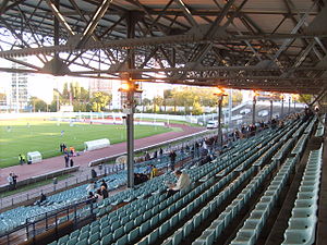
Stade Yves-du-Manoir
Stadium in Colombes, France
Distance: Approx. 2010 meters
Latitude and longitude: 48.92944444,2.24805556
The Stade Yves-du-Manoir (officially Stade olympique Yves-du-Manoir, also known as the Stade olympique de Colombes, or simply Colombes to the locals) is a rugby, track, and association football stadium in Colombes, near Paris, France.

Paris Nanterre University
French university in the Academy of Versailles
Distance: Approx. 2323 meters
Latitude and longitude: 48.90388889,2.21388889
Paris Nanterre University (French: Université Paris Nanterre), formerly Paris-X and commonly referred to as Nanterre, is a public research university based in Nanterre, Hauts-de-Seine, France, in the Paris metropolitan area. It is one of the most prestigious French universities, mainly in the areas of law, humanities, political science, social and natural sciences and economics. It is one of the thirteen successor universities of the University of Paris.

Bezons
Commune in Île-de-France, France
Distance: Approx. 368 meters
Latitude and longitude: 48.9261,2.2178
Bezons (French pronunciation: [bəzɔ̃] ) is a commune in the northwestern suburbs of Paris, France. It is located 12.6 km (7.8 mi) from the centre of Paris.

Houilles
Commune in Île-de-France, France
Distance: Approx. 2396 meters
Latitude and longitude: 48.9261,2.1892
Houilles (French pronunciation: [uj] ) is a commune in the Yvelines department in the Île-de-France region in north-central France. It is a northwestern suburb of Paris, located 14.2 km (8.8 mi) from the center of Paris.
Paris Lumières University Group
French association of universities and higher education institutions
Distance: Approx. 2324 meters
Latitude and longitude: 48.9039,2.2138
Université Paris Lumières was an association of universities and higher education institutions (ComUE) for institutions of higher education, research and culture in the Île-de-France (including Paris) region of France. The association was created as a ComUE according to the 2013 Law on Higher Education and Research (France), effective 29 December 2014. The association disappears in 2024.
Canton of Colombes-1
Administrative division of Hauts-de-Seine, France
Distance: Approx. 2164 meters
Latitude and longitude: 48.93,2.25
The canton of Colombes-1 is an administrative division of the Hauts-de-Seine department, in northern France. It was created at the French canton reorganisation which came into effect in March 2015. Its seat is in Colombes.

Canton of Colombes-2
Administrative division of Hauts-de-Seine, France
Distance: Approx. 2058 meters
Latitude and longitude: 48.91,2.24
The canton of Colombes-2 is an administrative division of the Hauts-de-Seine department, in northern France. It was created at the French canton reorganisation which came into effect in March 2015. Its seat is in Colombes.
Canton of Argenteuil-3
Distance: Approx. 2214 meters
Latitude and longitude: 48.94,2.24
The canton of Argenteuil-3 is an administrative division of the Val-d'Oise department, Île-de-France region, northern France. It was created at the French canton reorganisation which came into effect in March 2015. Its seat is in Argenteuil.
Canton of Houilles
Distance: Approx. 2417 meters
Latitude and longitude: 48.93,2.19
The canton of Houilles is an administrative division of the Yvelines department, northern France. Its borders were modified at the French canton reorganisation which came into effect in March 2015. Its seat is in Houilles.

La Garenne-Colombes station
Railway station in La Garenne-Colombes, France
Distance: Approx. 2103 meters
Latitude and longitude: 48.90943407,2.2399216
La Garenne-Colombes station is a French railway station serving the commune of La Garenne-Colombes on the Paris–Saint-Germain-en-Laye railway. It is largely located on the territory of the commune of Colombes, on the edge of the commune of La Garenne-Colombes, from where the main entrance to the station is located on Rue de l'Arrivée. This station is served by trains from the Line L of the Transilien commuter rail network.
Weather in this IP's area
light intensity drizzle
13 Celsius
13 Celsius
12 Celsius
14 Celsius
1014 hPa
99 %
1014 hPa
1011 hPa
8000 meters
4.63 m/s
340 degree
100 %
08:16:23
18:55:41