Country:
 Brazil
Region:
City:
Latitude and Longitude:
Time Zone:
Postal Code:
IP information under different IP Channel
ip-api
Country
Region
City
ASN
Time Zone
ISP
Blacklist
Proxy
Latitude
Longitude
Postal
Route
IPinfo
Country
Region
City
ASN
Time Zone
ISP
Blacklist
Proxy
Latitude
Longitude
Postal
Route
MaxMind
Country
Region
City
ASN
Time Zone
ISP
Blacklist
Proxy
Latitude
Longitude
Postal
Route
Luminati
Country
BRRegion
sp
City
saopaulo
ASN
Time Zone
America/Sao_Paulo
ISP
ORACLE-BMC-31898
Latitude
Longitude
Postal
db-ip
Country
Region
City
ASN
Time Zone
ISP
Blacklist
Proxy
Latitude
Longitude
Postal
Route
ipdata
Country
Region
City
ASN
Time Zone
ISP
Blacklist
Proxy
Latitude
Longitude
Postal
Route
Popular places and events near this IP address

B3 (stock exchange)
Brazilian stock exchange and OTC market
Distance: Approx. 233 meters
Latitude and longitude: -23.54638889,-46.63416667
B3 S.A. – Brasil, Bolsa, Balcão (in English, B3 – Brazil Stock Exchange and Over-the-Counter Market), formerly BM&FBOVESPA, is a stock exchange located in São Paulo, Brazil, and the second oldest of the country. Its current form can be traced back to May 8, 2008, when the São Paulo Stock Exchange (Bovespa) and the Brazilian Mercantile and Futures Exchange (BM&F) merged, creating BM&FBOVESPA. On March 30, 2017, BM&FBOVESPA merged with CETIP, creating B3. The benchmark indicator of B3 is the Índice Bovespa, more commonly known as Ibovespa.
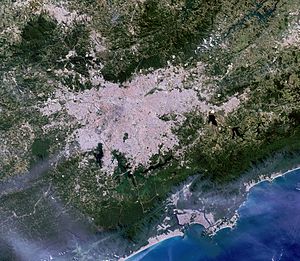
Greater São Paulo
Place in Brazil
Distance: Approx. 41 meters
Latitude and longitude: -23.54777778,-46.63583333
Greater São Paulo (Portuguese: Grande São Paulo) is a nonspecific term for one of the multiple definitions of the large metropolitan area located in the São Paulo state in Brazil.

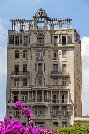
Barão de Iguape Building
Building in São Paulo, Brazil
Distance: Approx. 39 meters
Latitude and longitude: -23.54783333,-46.63597222
Barão de Iguape Building is a skyscraper in the older area of downtown São Paulo, Brazil, 133 metres (436 ft) in height with 37 floors, located on Patriarca square on the corner of Direita and Quitanda streets. Its construction was completed in 1959. The building was for years the headquarters of a bank, Unibanco, but this was transferred to another building on the Marginal Pinheiros expressway, next to Eusébio Matoso bridge in the southwestern neighborhood of Pinheiros.

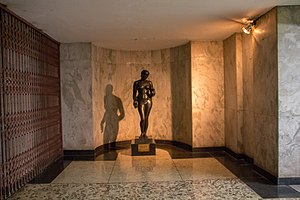
Matarazzo Building
Palace in São Paulo, Brazil
Distance: Approx. 153 meters
Latitude and longitude: -23.54767778,-46.63758889
Matarazzo Building (Portuguese: Edifício Matarazzo), also known as Palácio do Anhangabaú (Anhangabaú Palace), is the city hall of the city of São Paulo, Brazil. It belonged to Banespa until 2004, when it was sold to the city government. It was designed by Italian architect Marcello Piacentini under the will of Ermelino Matarazzo, in order to host the headquarters of his industries.

Viaduto do Chá
Bridge in São Paulo, Brazil
Distance: Approx. 198 meters
Latitude and longitude: -23.546647,-46.6378
Viaduto do Chá ("Tea Viaduct") is a viaduct of São Paulo, Brazil. It was the first viaduct built in the city, and was instigated by Jules Martin, a French immigrant to the city. The 240-metre (790 ft) span crosses the Vale do Anhangabaú.

Igreja de Santo Antônio (São Paulo)
Catholic Temple in São Paulo, Brazil
Distance: Approx. 66 meters
Latitude and longitude: -23.54777778,-46.63666667
The Church of Saint Anthony (Portuguese: Igreja de Santo Antônio) is a Catholic temple located in Patriarca Square, in the center of the Brazilian city of São Paulo. Established in 1592, the current church was completed between 1899 and 1919. It housed the Franciscan Order in the 17th century and was subordinated to the Brotherhood of Our Lady of the Rosary of White Men in the 18th century.

Vale do Anhangabaú
Distance: Approx. 195 meters
Latitude and longitude: -23.54597,-46.63704
Vale do Anhangabaú (Anhangabaú Valley) is a region in the city center of São Paulo, located between the viaducts do Chá and Santa Ifigênia. It is a public space commonly characterized as park, where events have traditionally been organized, such as public demonstrations, political rallies, presentations and popular shows. It is considered the point that separates the Old City Center from the New City Center.
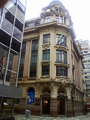
Sampaio Moreira Building
Historical building built in 1924, located in São Paulo, Brazil.
Distance: Approx. 93 meters
Latitude and longitude: -23.54666667,-46.63611111
The Sampaio Moreira Building (Portuguese: Edifício Sampaio Moreira) is located at 346, Líbero Badaró street, in the central region of São Paulo. With twelve floors and 50 metres (160 ft) high, the building was named Sampaio Moreira after its owner José de Sampaio Moreira (1866–1943), a merchant who the architect Christiano Stockler convinced in 1920 to make the building that would complete the Anhangabaú Park monument, which was finished four years later.

Patriarca Square
Square in São Paulo, Brazil
Distance: Approx. 43 meters
Latitude and longitude: -23.54777778,-46.63638889
The Patriarca Square (Portuguese: Praça do Patriarca) is located in the Sé district, in the historic center of the Brazilian city of São Paulo. It was inaugurated without a name in the 1910s and remained so until 1922, the year of the centenary of Brazil's Independence, when it was renamed Patriarca José Bonifácio Square; in the 1950s it was shortened to Patriarca Square. The place connects to important points in the city center, such as: Anhangabaú Valley, Viaduto do Chá, and Líbero Badaró, Direita, São Bento, Quitanda and 15 de Novembro Streets.
Prestes Maia Gallery
Art space in São Paulo, Brazil
Distance: Approx. 108 meters
Latitude and longitude: -23.54731389,-46.63714167
The Prestes Maia Gallery (Portuguese: Galeria Prestes Maia) is an artistic and cultural space located in the city of São Paulo that has an underground connection between Patriarca Square and Anhangabaú Valley, with an exit under the Viaduto do Chá. In 1955, the first public escalators in the city were inaugurated in the gallery's passageway.
Banco do Brasil Cultural Center (São Paulo)
Cultural space in São Paulo, Brazil
Distance: Approx. 152 meters
Latitude and longitude: -23.5475,-46.63461111
The Banco do Brasil Cultural Center (Portuguese: Centro Cultural Banco do Brasil) in São Paulo, also known as CCBB São Paulo, opened on April 21, 2001. It is located in Álvares Penteado Street, in the historic center of São Paulo, and can be accessed by metro from São Bento Station. Currently, the streets around the building are pedestrian-only.
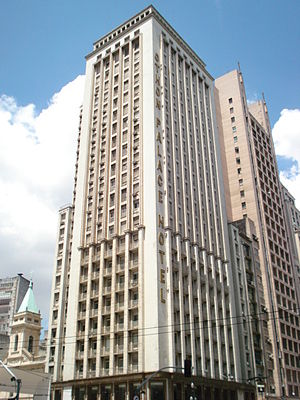
Othon Palace Hotel
Hotel in São Paulo, Brazil
Distance: Approx. 81 meters
Latitude and longitude: -23.54783333,-46.63680556
Othon Palace Hotel is located in the historic center of the Brazilian city of São Paulo. Founded by Othon Lynch Bezerra de Mello in 1954, it was part of a hotel network with units in São Paulo, Rio de Janeiro, Belo Horizonte and five other countries (United States, France, Portugal, Argentina and Peru).
Weather in this IP's area
overcast clouds
17 Celsius
17 Celsius
16 Celsius
17 Celsius
1019 hPa
91 %
1019 hPa
932 hPa
8000 meters
1.79 m/s
2.24 m/s
116 degree
100 %
05:59:52
18:01:21