Country:
Region:
City:
Latitude and Longitude:
Time Zone:
Postal Code:
IP information under different IP Channel
ip-api
Country
Region
City
ASN
Time Zone
ISP
Blacklist
Proxy
Latitude
Longitude
Postal
Route
Luminati
Country
Region
gr
City
groningen
ASN
Time Zone
Europe/Amsterdam
ISP
SURF B.V.
Latitude
Longitude
Postal
IPinfo
Country
Region
City
ASN
Time Zone
ISP
Blacklist
Proxy
Latitude
Longitude
Postal
Route
db-ip
Country
Region
City
ASN
Time Zone
ISP
Blacklist
Proxy
Latitude
Longitude
Postal
Route
ipdata
Country
Region
City
ASN
Time Zone
ISP
Blacklist
Proxy
Latitude
Longitude
Postal
Route
Popular places and events near this IP address

Stadion Oosterpark
Football stadium
Distance: Approx. 179 meters
Latitude and longitude: 53.22694444,6.58027778
Oosterpark Stadion (Dutch pronunciation: [ˌoːstərˈpɑr(ə)k ˈstaːdijɔn]) was the stadium of football club FC Groningen until December 2005. The all-seater stadium in Groningen's Oosterpark neighbourhood was inaugurated on 30 September 1933 and renovated in 1960, 1984 and 1987/88. The stadium has been replaced by the new, larger Euroborg stadium, and the ground it occupied is being redeveloped.

Groninger Studentencorps Vindicat atque Polit
Dutch student association
Distance: Approx. 1278 meters
Latitude and longitude: 53.218717,6.568542
The Groninger Studenten Corps Vindicat atque Polit (Latin for Uphold and Refine (lit. (The sword) avenges and (the file) scrapes)) is the second oldest Dutch student association and was founded on February 4, 1815, as a reaction to attacks on students from local citizens. The first rector of the senate was B.J. Winter.

Martinikerk (Groningen)
Church in Groningen , Netherlands
Distance: Approx. 1256 meters
Latitude and longitude: 53.21916667,6.56833333
The Martinikerk (Martin's church) is the oldest church in Groningen, Netherlands. The church and its associated tower (the Martinitoren) are named after Saint Martin of Tours (316–397), the patron saint of the Bishopric of Utrecht to which Groningen belonged. The church was a cathedral for a short period during the first bishopric of Groningen (1559–1594).
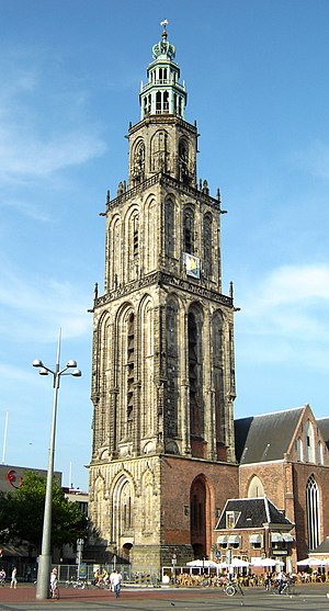
Martinitoren
Church building in Groningen, Netherlands
Distance: Approx. 1270 meters
Latitude and longitude: 53.21921,6.568
The Martinitoren (Dutch pronunciation: [mɑrˈtinitoːrə(n)]; Martini or St. Martin's Tower) is the tallest church steeple in the city of Groningen, Netherlands, and the bell tower of the Martinikerk. The tower is located at the north-eastern corner of the Grote Markt (Main Market Square).

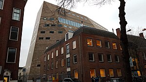
Forum Groningen
Cultural center in Groningen
Distance: Approx. 1190 meters
Latitude and longitude: 53.21880556,6.57023611
Forum Groningen is a cultural center in the city of Groningen in the northern Netherlands that houses a library, cinema, and parts of the Groninger Museum. Forum Groningen opened in November 2019, and is expected to receive 1.6 million visitors annually. The center is located next to the Great Market Square and the New Market and is part of larger reconstruction plans of the Great Market Square's eastern side.

University Medical Center Groningen
Hospital in Groningen, Netherlands
Distance: Approx. 736 meters
Latitude and longitude: 53.2225,6.57388889
The University Medical Center Groningen (UMCG, Dutch: Universitair Medisch Centrum Groningen), formerly Groningen University Hospital, is the main hospital in Groningen, Netherlands. The medical centre is affiliated with the University of Groningen and offers supraregional tertiary care to the northern part of the Netherlands. It employs almost 17,000 people and numbers almost 1400 beds.

Praedinius Gymnasium
Distance: Approx. 951 meters
Latitude and longitude: 53.2211,6.5716
Praedinius Gymnasium is a gymnasium in Groningen, the Netherlands. It dates back to the fourteenth century and is the larger of two non-comprehensive gymnasia in Groningen, the other being Willem Lodewijk Gymnasium.
Sint Geertruidsgasthuis
Distance: Approx. 1299 meters
Latitude and longitude: 53.21694444,6.57138889
The Pepergasthuis (also known as the Sint Geertruidsgasthuis) is a hofje on the Peperstraat in Groningen, Netherlands.

Prinsentuin (Groningen)
Renaissance-style garden in the Netherlands
Distance: Approx. 1066 meters
Latitude and longitude: 53.22166667,6.56888889
The Prinsentuin (English: Prince's garden) or, Prinsenhoftuin is a garden built in renaissance style that is located in Groningen, behind the Prinsenhof. This Garden consists of a rose garden, a herb garden, a part with berceaus and a sundial on the wall above the entrance. The letters 'W' and 'A', the beginletters of stadtholder Willem Frederik of Nassau and his wife Countess Albertine Agnes of Nassau, are planted in the Prinsentuin to, using hedges.

H.N. Werkman College
Distance: Approx. 963 meters
Latitude and longitude: 53.2201,6.5729
H.N. Werkman College is a Dutch High School in the city of Groningen. The school is named after the Dutch artist, typographer and printer Hendrik Nicolaas Werkman. The school is divided over four buildings: Stadslyceum, Dalton, Kluiverboom and Vinkenstraat.
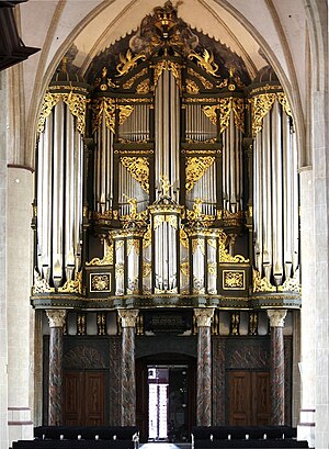
Organ in the Martinikerk at Groningen
Historic organ in Groningen, Netherlands
Distance: Approx. 1256 meters
Latitude and longitude: 53.21916667,6.56833333
The west gallery organ of the Martinikerk in Groningen dates from the 15th century; it took its present form in the 18th century when it was expanded by Arp Schnitger, his son Franz Caspar Schnitger and his successor Albertus Antonius Hinsz. It has 52 speaking stops on three manuals and pedal, and is one of the largest and most famous baroque organs in Northern Europe.

Oosterkerk, Groningen
Church in Groningen, Netherlands
Distance: Approx. 687 meters
Latitude and longitude: 53.22666667,6.5725
The Oosterkerk (English: Eastern Church) is a reformed church from 1929 in the Dutch city of Groningen. It is located in the Oosterparkbuurt, on the corner of the E. Thomassen à Thuessinklaan and the S.S. Rosensteinlaan.
Weather in this IP's area
heavy intensity rain
6 Celsius
3 Celsius
5 Celsius
7 Celsius
1007 hPa
85 %
1007 hPa
1007 hPa
10000 meters
5.14 m/s
240 degree
20 %
08:02:32
16:35:08

