Country:
Region:
City:
Latitude and Longitude:
Time Zone:
Postal Code:
IP information under different IP Channel
ip-api
Country
Region
City
ASN
Time Zone
ISP
Blacklist
Proxy
Latitude
Longitude
Postal
Route
Luminati
Country
Region
ad
City
ngaoundere
ASN
Time Zone
Africa/Douala
ISP
MTN-NS-CAMEROON
Latitude
Longitude
Postal
IPinfo
Country
Region
City
ASN
Time Zone
ISP
Blacklist
Proxy
Latitude
Longitude
Postal
Route
db-ip
Country
Region
City
ASN
Time Zone
ISP
Blacklist
Proxy
Latitude
Longitude
Postal
Route
ipdata
Country
Region
City
ASN
Time Zone
ISP
Blacklist
Proxy
Latitude
Longitude
Postal
Route
Popular places and events near this IP address

Adamawa Region
Region of Cameroon
Distance: Approx. 7688 meters
Latitude and longitude: 7.33333333,13.5
The Adamawa Region (French: Région de l'Adamaoua) is a constituent region of the Republic of Cameroon. It borders the Centre and East regions to the south, the Northwest and West regions to the southwest, Nigeria to the west, the Central African Republic (CAR) to the east, and the North Region to the north. This mountainous area forms the barrier between Cameroon's forested south and savanna north.

Ngaoundéré
Place in Adamawa, Cameroon
Distance: Approx. 1870 meters
Latitude and longitude: 7.31666667,13.58333333
Ngaoundéré or N'Gaoundéré (Fula: N'gamdere, نغَمْدٜرٜ, 𞤲'𞤺𞤢𞤥𞤣𞤫𞥅𞤪𞤫𞥅) is the capital of the Adamawa Region of Cameroon. It had a population of 152,700 at the 2005 census. According to the film Les Mairuuwas – Maitre de l'eau produced by the University of Tromsø, the population has rapidly risen to 1,000,000 (as of October 2016) owing to mass immigration from the Central African Republic and the perceived danger from Boko Haram in northern Cameroon.
Ngaoundéré Airport
Airport in Adamawa, Cameroon
Distance: Approx. 4928 meters
Latitude and longitude: 7.35713889,13.55919444
Ngaoundéré Airport (IATA: NGE, ICAO: FKKN), also known as N'Gaoundéré Airport, is an airport serving Ngaoundéré (also spelled N'Gaoundéré), the capital of the Adamawa Province in Cameroon.
Roman Catholic Diocese of Ngaoundéré
Roman Catholic diocese in Cameroon
Distance: Approx. 1153 meters
Latitude and longitude: 7.3206,13.5743
The Roman Catholic Diocese of Ngaoundéré (Latin: Ngaunderen(sis)) is a diocese located in the city of Ngaoundéré in the ecclesiastical province of Garoua in Cameroon.

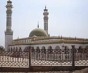
Lamido Grand Mosque
Mosque in Ngaoundéré, Cameroon
Distance: Approx. 2230 meters
Latitude and longitude: 7.3209328,13.585453
Lamido Grand Mosque is a mosque in Ngaoundéré, Cameroon.

Protestant Hospital of Ngaoundéré
Hospital in Adamawa Region, Cameroon
Distance: Approx. 3357 meters
Latitude and longitude: 7.309382,13.596818
The Protestant Hospital of Ngaoundéré is a Protestant hospital in N'Gaoundere, Cameroon. Founded by Norwegian missionaries of the Norwegian Missionary Society in 1925, and partly funded by a wealthy American donator in Cameroon and the Evangelical Lutheran Church of Cameroon, the hospital has been in full operation since 1957. The Protestant Hospital of Ngaoundéré today employs over 127 people.
Battle of Ngaundere
Distance: Approx. 2216 meters
Latitude and longitude: 7.32166667,13.585
The Battle of Ngaundere or Battle of Ngaoundéré was a small engagement fought between German and British forces on 29 June 1915 during the Kamerun campaign of World War I. It resulted in a German defeat and British occupation of the town.

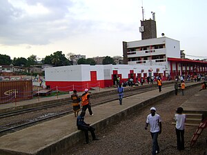
Ngaoundéré Central Station
Railway station in Ngaoundéré, Cameroon
Distance: Approx. 3775 meters
Latitude and longitude: 7.3385,13.5898
The Ngaoundéré Central Station (Gare centrale de Ngaoundéré in French) is the main railway station in Ngaoundéré, Cameroon. It is located on the Yaoundé-Bélabo-Ngaoundéré line of the Camrail network. The station was opened on December 10, 1974.
Weather in this IP's area
few clouds
19 Celsius
19 Celsius
19 Celsius
19 Celsius
1011 hPa
64 %
1011 hPa
880 hPa
10000 meters
1.65 m/s
1.77 m/s
81 degree
14 %
05:56:32
17:44:06