128.92.3.43 - IP Lookup: Free IP Address Lookup, Postal Code Lookup, IP Location Lookup, IP ASN, Public IP
Country:
Region:
City:
Location:
Time Zone:
Postal Code:
IP information under different IP Channel
ip-api
Country
Region
City
ASN
Time Zone
ISP
Blacklist
Proxy
Latitude
Longitude
Postal
Route
Luminati
Country
Region
al
City
birmingham
ASN
Time Zone
America/Chicago
ISP
CHARTER-20115
Latitude
Longitude
Postal
IPinfo
Country
Region
City
ASN
Time Zone
ISP
Blacklist
Proxy
Latitude
Longitude
Postal
Route
IP2Location
128.92.3.43Country
Region
alabama
City
gardendale
Time Zone
America/Chicago
ISP
Language
User-Agent
Latitude
Longitude
Postal
db-ip
Country
Region
City
ASN
Time Zone
ISP
Blacklist
Proxy
Latitude
Longitude
Postal
Route
ipdata
Country
Region
City
ASN
Time Zone
ISP
Blacklist
Proxy
Latitude
Longitude
Postal
Route
Popular places and events near this IP address

Fultondale, Alabama
City in Alabama, United States
Distance: Approx. 5652 meters
Latitude and longitude: 33.63472222,-86.77944444
Fultondale is a city in Jefferson County, Alabama, United States and a northern suburb of Birmingham. As of the 2010 census, the population of the city is 8,380.

Gardendale, Alabama
City in Alabama, United States
Distance: Approx. 1919 meters
Latitude and longitude: 33.65611111,-86.81055556
Gardendale is a city in Jefferson County, Alabama, United States and a northern suburb of Birmingham. The population was 16,044 at the 2020 census.

Mount Olive, Jefferson County, Alabama
Unincorporated community in Alabama, United States
Distance: Approx. 4953 meters
Latitude and longitude: 33.684191,-86.875139
Mount Olive, also spelled Mt. Olive is an unincorporated community and a census-designated place (CDP) in Jefferson County, Alabama. Its location is in the suburbs of Birmingham.
Watson, Alabama
Unincorporated community in Alabama, United States
Distance: Approx. 6339 meters
Latitude and longitude: 33.63361111,-86.87944444
Watson, also known as Mineral Springs, is an unincorporated community in Jefferson County, Alabama, United States. The community is bordered by Brookside on the north and west, by Birmingham and Gardendale on the east and by Birmingham on the south. A post office first opened in Watson in 1903.
Fultondale High School (1965–2021)
Public school in Fultondale, Alabama, United States
Distance: Approx. 6004 meters
Latitude and longitude: 33.63233333,-86.77691667
Fultondale High School was a combined middle school and high school in the Birmingham, Alabama suburb of Fultondale. It was one of fourteen high schools in the Jefferson County School System. School colors were navy blue and Burnt orange, and the athletic teams were called the Wildcats.

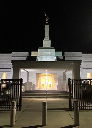
Birmingham Alabama Temple
Temple of the LDS church
Distance: Approx. 770 meters
Latitude and longitude: 33.674426,-86.821347
The Birmingham Alabama Temple is the 98th operating temple of the Church of Jesus Christ of Latter-day Saints (LDS Church).

Gardendale High School
Public school in Gardendale, Alabama, United States
Distance: Approx. 2823 meters
Latitude and longitude: 33.64538,-86.81217
Gardendale High School (GHS) is a public high school located in the Birmingham, Alabama suburb of Gardendale. It is currently operated by the Jefferson County Board of Education. GHS was established in 1956 as a result of population growth in the area.

Roman Catholic Diocese of Birmingham in Alabama
Latin Catholic ecclesiastical jurisdiction in Alabama, USA
Distance: Approx. 2249 meters
Latitude and longitude: 33.65333333,-86.80888889
The Diocese of Birmingham in Alabama is a Latin Church ecclesiastical territory. or diocese, of the Catholic Church that encompasses the northern 39 counties of Alabama in the United States. It was erected on December 9, 1969, with territory from what is now the Archdiocese of Mobile.
Gardendale First Baptist Church
Church in the United States
Distance: Approx. 2408 meters
Latitude and longitude: 33.649393,-86.812574
Gardendale First Baptist Church (sometimes styled as "Gardendale's" or GFBC) is a Baptist megachurch in Gardendale, Alabama. It is affiliated with the Southern Baptist Convention. The senior pastor is Dr.
New Castle, Alabama
Unincorporated community in Alabama, United States
Distance: Approx. 5671 meters
Latitude and longitude: 33.64888889,-86.76861111
New Castle is an unincorporated community in Jefferson County, Alabama, United States. New Castle is 9 miles (14 km) north of downtown Birmingham. New Castle has a post office with ZIP code 35119.
Tarrant High School
Public school in Tarrant, Alabama, United States
Distance: Approx. 7733 meters
Latitude and longitude: 33.6141,-86.773
Tarrant High School (THS) is a fourteenth-year public high school in the city of Tarrant, Alabama. It is the only high school in the Tarrant City School System. School colors are navy blue and gold, and the athletic teams are called the Wildcats.
Fultondale High School (2023–present)
Public school in Fultondale, Alabama, United States
Distance: Approx. 6436 meters
Latitude and longitude: 33.627,-86.7766
Fultondale High School is a combined middle school and high school located in Fultondale, Alabama. It is one of fourteen schools within the Jefferson County School System. The school opened after the previous Fultondale High School, established in 1965, was destroyed after damage from a tornado in 2021.
Weather in this IP's area
few clouds
10 Celsius
9 Celsius
8 Celsius
11 Celsius
1018 hPa
52 %
1018 hPa
997 hPa
10000 meters
1.54 m/s
20 %