128.92.13.117 - IP Lookup: Free IP Address Lookup, Postal Code Lookup, IP Location Lookup, IP ASN, Public IP
Country:
Region:
City:
Location:
Time Zone:
Postal Code:
IP information under different IP Channel
ip-api
Country
Region
City
ASN
Time Zone
ISP
Blacklist
Proxy
Latitude
Longitude
Postal
Route
Luminati
Country
Region
al
City
birmingham
ASN
Time Zone
America/Chicago
ISP
CHARTER-20115
Latitude
Longitude
Postal
IPinfo
Country
Region
City
ASN
Time Zone
ISP
Blacklist
Proxy
Latitude
Longitude
Postal
Route
IP2Location
128.92.13.117Country
Region
california
City
red bluff
Time Zone
America/Los_Angeles
ISP
Language
User-Agent
Latitude
Longitude
Postal
db-ip
Country
Region
City
ASN
Time Zone
ISP
Blacklist
Proxy
Latitude
Longitude
Postal
Route
ipdata
Country
Region
City
ASN
Time Zone
ISP
Blacklist
Proxy
Latitude
Longitude
Postal
Route
Popular places and events near this IP address

Red Bluff, California
City in California, United States
Distance: Approx. 1854 meters
Latitude and longitude: 40.17666667,-122.23805556
Red Bluff is a city in and the county seat of Tehama County, California, United States. The population was 14,710 at the 2020 census, up from 14,076 at the 2010 census. It is located 131 miles (211 kilometers) north of Sacramento, 31 miles (50 km) south of Redding, and it is bisected by Interstate 5.
Mercy High School (Red Bluff, California)
Private school in Red Bluff, California, United States
Distance: Approx. 2520 meters
Latitude and longitude: 40.17416667,-122.23055556
Mercy High School is a private, Roman Catholic high school in Red Bluff, California. It is located in the Roman Catholic Diocese of Sacramento.
Red Bluff Municipal Airport
Airport in Red Bluff, California
Distance: Approx. 3070 meters
Latitude and longitude: 40.15083333,-122.25222222
Red Bluff Municipal Airport (IATA: RBL, ICAO: KRBL, FAA LID: RBL) is two miles south of Red Bluff, located just off Interstate 5 in Tehama County, California. It was previously known as Bidwell Airport. It has no scheduled airline flights; United Airlines dropped Red Bluff in 1952, Pacific Air Lines left in 1962 and the airport has had few or no airline flights since.
Red Bluff High School
Public school in Red Bluff, California, United States
Distance: Approx. 825 meters
Latitude and longitude: 40.17689,-122.25017
Red Bluff High School is a public school in Red Bluff, California. The institution offers courses from the ninth grade to the twelfth grade and is a member of the Red Bluff Joint Union High School District. The campus is located at 1260 Union Street in Red Bluff.

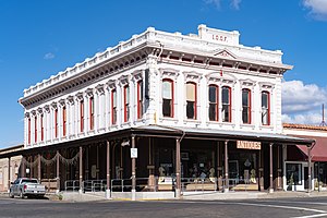
Odd Fellows Building (Red Bluff, California)
United States historic place
Distance: Approx. 2184 meters
Latitude and longitude: 40.17666667,-122.23416667
The Odd Fellows Building in Red Bluff, California was built during 1882–83. It was the fourth home of the I.O.O.F. Lodge #76, one of the oldest Odd Fellows groups in Northern California. It is a two-story 100 feet (30 m) by 45 feet (14 m)red brick building with Italianate style designed by architect A. A. Cook of Sacramento.
State Theatre (Red Bluff, California)
United States historic place
Distance: Approx. 2186 meters
Latitude and longitude: 40.17638889,-122.23416667
The State Theatre is a Moderne style cinema in Red Bluff, California, USA. It was built in 1945-46 to a design by architects Alexander A. and Mackenzie A. Cantin, replacing a theater that had burned two years before. It provided the only public stage in Tehama County until 1991, and was the only cinema until 1993.

Old Bank of America Building (Red Bluff, California)
United States historic place
Distance: Approx. 2133 meters
Latitude and longitude: 40.17777778,-122.23472222
The Old Bank of America Building at 710 Main St. in Red Bluff, California, was built in 1925. It was designed by architect William H. Weeks.

Saint Mary's Parish (Red Bluff, California)
Historic church in California, United States
Distance: Approx. 2312 meters
Latitude and longitude: 40.17555556,-122.23277778
Saint Mary's Parish (Sacred Heart Catholic Church) is a historic church at 515 Main Street in Red Bluff, California. It was built in 1906 and added to the National Register in 1982.
Brewery Creek
Tributary of the Sacramento River in California
Distance: Approx. 1923 meters
Latitude and longitude: 40.1842,-122.2388
Brewery Creek is a stream in the U.S. state of California. The stream runs 2.25 miles (3.62 km) before it empties into the Sacramento River. Brewery Creek was so named for the breweries near its course.
Brickyard Creek
Stream in California, U.S.
Distance: Approx. 2284 meters
Latitude and longitude: 40.1703,-122.2348
Brickyard Creek is a stream in the U.S. state of California. The steam runs 9 miles (14 km) before it empties into Reeds Creek. Brickyard was so named for a brick factory near its course.
Reeds Creek
Stream in California, U.S.
Distance: Approx. 2784 meters
Latitude and longitude: 40.1722,-122.2279
Reeds Creek is a stream in the U.S. state of California. The 20-mile (32 km) long stream is a tributary to the Sacramento River. Reeds Creek was named after Captain Elbridge Gerry Reed, an early settler.
Tehama County Superior Court
California superior court with jurisdiction over Tehama Country
Distance: Approx. 1034 meters
Latitude and longitude: 40.1701,-122.253
The Superior Court of California, County of Tehama, also known as the Tehama County Superior Court or Tehama Superior Court, is the California superior court with jurisdiction over Tehama County.
Weather in this IP's area
overcast clouds
9 Celsius
8 Celsius
9 Celsius
10 Celsius
1022 hPa
76 %
1022 hPa
1009 hPa
10000 meters
2.06 m/s
140 degree
100 %
