128.73.193.69 - IP Lookup: Free IP Address Lookup, Postal Code Lookup, IP Location Lookup, IP ASN, Public IP
Country:
Region:
City:
Location:
Time Zone:
Postal Code:
ISP:
ASN:
language:
User-Agent:
Proxy IP:
Blacklist:
IP information under different IP Channel
ip-api
Country
Region
City
ASN
Time Zone
ISP
Blacklist
Proxy
Latitude
Longitude
Postal
Route
db-ip
Country
Region
City
ASN
Time Zone
ISP
Blacklist
Proxy
Latitude
Longitude
Postal
Route
IPinfo
Country
Region
City
ASN
Time Zone
ISP
Blacklist
Proxy
Latitude
Longitude
Postal
Route
IP2Location
128.73.193.69Country
Region
kostromskaya oblast'
City
kostroma
Time Zone
Europe/Moscow
ISP
Language
User-Agent
Latitude
Longitude
Postal
ipdata
Country
Region
City
ASN
Time Zone
ISP
Blacklist
Proxy
Latitude
Longitude
Postal
Route
Popular places and events near this IP address

Kostroma
City in Kostroma Oblast, Russia
Distance: Approx. 173 meters
Latitude and longitude: 57.76805556,40.92694444
Kostroma (Russian: Кострома́, IPA: [kəstrɐˈma]) is a historic city and the administrative center of Kostroma Oblast, Russia. A part of the Golden Ring of Russian cities, it is located at the confluence of the rivers Volga and Kostroma. In the 2021 census, the population is 267,481.

Ipatievsky Monastery
Monastery in Russia
Distance: Approx. 2219 meters
Latitude and longitude: 57.77638889,40.89444444
The Ipatiev Monastery (Russian: Ипатьевский монастырь; also Ipatievsky Monastery), sometimes translated into English as Hypatian Monastery, is a male monastery situated on the bank of the Kostroma River just opposite the city of Kostroma. It was founded around 1330 by a Tatar convert, Prince Chet, whose male-line descendants included Solomonia Saburova and Tsar Boris Godunov, and is dedicated to St. Hypatios of Gangra.

Kostroma Airport
Airport in Russia
Distance: Approx. 6466 meters
Latitude and longitude: 57.79666667,41.02
Kostroma Airport (Russian: Аэропорт Кострома) (IATA: KMW, ICAO: UUBA) is an airport in Russia located 6 km northeast of Kostroma. It services propeller-driven transports.

Theophany Convent, Kostroma
Church in Kostroma, Russia
Distance: Approx. 740 meters
Latitude and longitude: 57.77307779,40.92509445
Bogoyavlensky Convent (Russian: Богоявленско-Анастасьин монастырь) is one of the most populous Russian Orthodox convents. It is situated in Kostroma and is known as the location of the ancient Feodorovskaya Icon of the Mother of God. It was founded as Bogoyavlensky (Theophany) Monastery in the 15th century by Nikita, a disciple and a relative of St Sergius of Radonezh.

Kostroma Gostiny Dvor
Distance: Approx. 53 meters
Latitude and longitude: 57.76611111,40.92638889
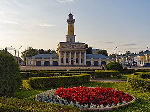
The Gostiny Dvor in Kostroma is the best preserved complex of provincial Neoclassical trading arcades in Russia. It was built on the site of the ancient Kostroma kremlin after the great fire of 1773. The complex comprises more than ten buildings constructed over a period of almost five decades.

Kostromskoy District
District in Kostroma Oblast, Russia
Distance: Approx. 382 meters
Latitude and longitude: 57.76666667,40.93333333
Kostromskoy District (Russian: Костромско́й райо́н) is an administrative and municipal district (raion), one of the twenty-four in Kostroma Oblast, Russia. It is located in the southwest of the oblast. The area of the district is 2,032 square kilometers (785 sq mi).

Kostroma Governorate
1796–1929 unit of Russia
Distance: Approx. 381 meters
Latitude and longitude: 57.7667,40.9333
Kostroma Governorate (Russian: Костромская губерния, romanized: Kostromskaya guberniya) was an administrative-territorial unit (guberniya) of the Russian Empire and the Russian SFSR, which existed from 1796 to 1929. Its administrative center was in the city of Kostroma.

Church of the Resurrection, Kostroma
Distance: Approx. 1774 meters
Latitude and longitude: 57.75555556,40.94861111
Church of the Resurrection is church of the Diocese of Kostroma of the Russian Orthodox Church in Kostroma, Russia near the Volga River.

NBC Defense Military Academy
Education organization in Kostroma, Russia
Distance: Approx. 1114 meters
Latitude and longitude: 57.77638889,40.92972222
The Marshal Semyon Timoshenko Nuclear, Biological and Chemical Defense Military Academy (Военная академия РХБ защиты имени Маршала Советского Союза С. К. Тимошенко) is a military university in Kostroma training officers for service in the Russian NBC Defense Troops of the Russian Ground Forces. It was established in 1932 in Moscow and is named after Semyon Timoshenko. It provides training and conducts research related to the protection of military and civilian personnel from the weapons of mass destruction.
Kostroma café fire
2022 conflagration in Russia
Distance: Approx. 2805 meters
Latitude and longitude: 57.76388889,40.97388889
In the early hours of 5 November 2022, a fire occurred at the Poligon café in the city of Kostroma, Kostroma Oblast, Russia. The fire killed 15 people and injured 9 others. 250 other people were evacuated.
Kostroma State University
University in kostroma, Russia
Distance: Approx. 1225 meters
Latitude and longitude: 57.75974,40.943186
Kostroma State University (Russian: Федеральное государственное бюджетное образовательное учреждение высшего образования «Костромской государственный университет» (КГУ)) is a public university in Kostroma, the capital city of Kostroma Oblast in Russia. It was created in its current form in 2016 with the merger of the Nekrasov Kostroma State University and the Kostroma State Technological University.
Weather in this IP's area
overcast clouds
1 Celsius
-3 Celsius
1 Celsius
1 Celsius
1013 hPa
97 %
1013 hPa
999 hPa
10000 meters
4.36 m/s
11.28 m/s
246 degree
92 %