Country:
 USA
USARegion:
City:
Latitude and Longitude:
Time Zone:
Postal Code:
IP information under different IP Channel
ip-api
Country
Region
City
ASN
Time Zone
ISP
Blacklist
Proxy
Latitude
Longitude
Postal
Route
IPinfo
Country
Region
City
ASN
Time Zone
ISP
Blacklist
Proxy
Latitude
Longitude
Postal
Route
MaxMind
Country
Region
City
ASN
Time Zone
ISP
Blacklist
Proxy
Latitude
Longitude
Postal
Route
Luminati
Country
USASN
Time Zone
America/Chicago
ISP
WINDSTREAM
Latitude
Longitude
Postal
db-ip
Country
Region
City
ASN
Time Zone
ISP
Blacklist
Proxy
Latitude
Longitude
Postal
Route
ipdata
Country
Region
City
ASN
Time Zone
ISP
Blacklist
Proxy
Latitude
Longitude
Postal
Route
Popular places and events near this IP address

Forest Hills, Queens
Neighborhood in New York City
Distance: Approx. 933 meters
Latitude and longitude: 40.715,-73.845
Forest Hills is a neighborhood in the central portion of the borough of Queens in New York City. It is adjacent to Corona to the north, Rego Park and Glendale to the west, Forest Park to the south, Kew Gardens to the southeast, and Flushing Meadows–Corona Park to the east. The area was originally referred to as "Whitepot".

Forest Hills–71st Avenue station
New York City Subway station in Queens
Distance: Approx. 404 meters
Latitude and longitude: 40.721404,-73.844004
The Forest Hills–71st Avenue station (previously known as 71st–Continental Avenues station) is an express station on the IND Queens Boulevard Line of the New York City Subway, located on Queens Boulevard at 71st (Continental) Avenue in Forest Hills, Queens. It is served by the E and F trains at all times, the <F> train during rush hours in the reverse peak direction, the M train on weekdays during the day, and the R train at all times except late nights. It serves as the terminus for the M and R services.
Forest Hills High School (New York)
Public school in New York City
Distance: Approx. 807 meters
Latitude and longitude: 40.7298,-73.845
Forest Hills High School (FHHS) is a high school in Forest Hills, Queens, New York City. Dedicated in 1937, it educates students in grades 9–12 and is operated by the New York City Department of Education. The school serves students from Forest Hills and Rego Park, as well as other nearby Queens neighborhoods such as Corona, East Elmhurst, Elmhurst, Flushing, Jackson Heights, Jamaica, Kew Gardens, Maspeth, Middle Village, and Woodside.

67th Avenue station
New York City Subway station in Queens
Distance: Approx. 635 meters
Latitude and longitude: 40.726966,-73.853703
The 67th Avenue station is a local station on the IND Queens Boulevard Line of the New York City Subway. Located at the intersection of 67th Avenue and Queens Boulevard in Forest Hills, Queens, it is served by the M train on weekdays, the R train at all times except nights, and the E and F trains during late nights.

Forest Hills station (LIRR)
Rail road station in Queens, New York
Distance: Approx. 486 meters
Latitude and longitude: 40.719483,-73.844883
The Forest Hills station is a station on the Main Line of the Long Island Rail Road (LIRR), located in the Forest Hills neighborhood of Queens in New York City. It is lightly used compared to other stations in the city, with 2,408 daily riders in 2023; many residents opt for the subway because of its more frequent service, cheaper fares, and direct express trains to Midtown Manhattan. The station is wheelchair accessible.

West Side Tennis Club
Tennis club in New York City, USA
Distance: Approx. 380 meters
Latitude and longitude: 40.7196,-73.8487
The West Side Tennis Club is a private tennis club located in Forest Hills, a neighborhood in the New York City borough of Queens. The club has 38 tennis courts in all four surfaces (clay court, Har-Tru, grass court and hardcourt), a junior Olympic-size swimming pool and other amenities. It is the home of the Forest Hills Stadium (originally Forest Hills Tennis Stadium), a 14,000 seat outdoor tennis stadium and concert venue.

Bramson ORT College
Distance: Approx. 174 meters
Latitude and longitude: 40.72145,-73.84856389
Bramson ORT College was a nonprofit private two-year college in New York City. Its main campus was located in Forest Hills, Queens, with a satellite campus in Brooklyn. It was affiliated with ORT America, a volunteer organization that is the umbrella organization of ORT in the United States, and World ORT, the parent nonprofit global Jewish organization that promotes education and training in over 100 countries.

United States Post Office (Forest Hills, Queens)
Historic post office in Queens, New York
Distance: Approx. 174 meters
Latitude and longitude: 40.72166667,-73.84722222
US Post Office-Forest Hills Station is a historic post office building located at Forest Hills in Queens County, New York, United States. It was built in 1937, and was designed by architect Lorimer Rich as a consultant to the Office of the Supervising Architect. It is a one-story flat roofed building clad with reddish brown terra cotta above a base of granite in the International style.

Queens Jewish Center
Orthodox synagogue in Queens, New York
Distance: Approx. 811 meters
Latitude and longitude: 40.73027778,-73.84777778
The Queens Jewish Center, also known as Queens Jewish Center and Talmud Torah or QJC, is an Orthodox synagogue in Forest Hills, Queens, New York City, New York, United States. The synagogue was established by a dozen families in 1943 to serve the growing central Queens Jewish community. The current spiritual leader is Rabbi Judah Kerbel.
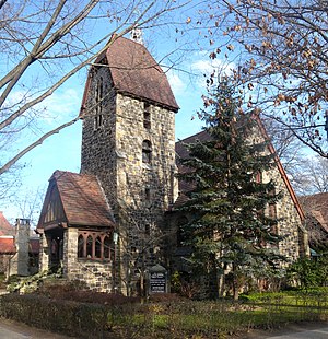
The Church-in-the-Gardens
United States historic place
Distance: Approx. 939 meters
Latitude and longitude: 40.71638889,-73.84138889
The Church-in-the-Gardens, also known as Community Congregational Christian Church, is a historic Congregational church complex located in Forest Hills, Queens, New York. The complex includes the church (1915), Community House (1926), and Parish Hall (1953) connected by breezeways and a separate parsonage (1929). The buildings are all in an eclectic Tudor Revival style.

Long Island Jewish Forest Hills
Hospital in New York, United States
Distance: Approx. 728 meters
Latitude and longitude: 40.729096,-73.851439
Long Island Jewish Forest Hills is a teaching hospital operating under the Northwell Health hospital network. It is located in Forest Hills, Queens, New York. The hospital is affiliated with the Donald and Barbara Zucker School of Medicine at Hofstra/Northwell, which sponsors a residency program in internal medicine.
La Stella Restaurant
Italian restaurant in Queens, NY
Distance: Approx. 406 meters
Latitude and longitude: 40.726027,-73.850993
La Stella Restaurant was an Italian restaurant in Forest Hills, Queens. La Stella was opened by Joe and Jack Taliercio in 1970. It closed in 1992.
Weather in this IP's area
clear sky
9 Celsius
7 Celsius
6 Celsius
10 Celsius
1027 hPa
66 %
1027 hPa
1025 hPa
10000 meters
4.02 m/s
360 degree
07:10:09
18:10:24