Country:
 USA
USARegion:
City:
Latitude and Longitude:
Time Zone:
Postal Code:
IP information under different IP Channel
ip-api
Country
Region
City
ASN
Time Zone
ISP
Blacklist
Proxy
Latitude
Longitude
Postal
Route
IPinfo
Country
Region
City
ASN
Time Zone
ISP
Blacklist
Proxy
Latitude
Longitude
Postal
Route
MaxMind
Country
Region
City
ASN
Time Zone
ISP
Blacklist
Proxy
Latitude
Longitude
Postal
Route
Luminati
Country
USRegion
mo
City
stlouis
ASN
Time Zone
America/Chicago
ISP
WUSTL-ASN
Latitude
Longitude
Postal
db-ip
Country
Region
City
ASN
Time Zone
ISP
Blacklist
Proxy
Latitude
Longitude
Postal
Route
ipdata
Country
Region
City
ASN
Time Zone
ISP
Blacklist
Proxy
Latitude
Longitude
Postal
Route
Popular places and events near this IP address

Richmond Heights, Missouri
City in Missouri, United States
Distance: Approx. 71 meters
Latitude and longitude: 38.62833333,-90.32861111
Richmond Heights is a city in St. Louis County, Missouri. It is an inner-ring suburb of St.

St. Louis Modern Chinese School
School in Missouri, United States
Distance: Approx. 1241 meters
Latitude and longitude: 38.63433,-90.31724
The St. Louis Modern Chinese School (SLMCS, simplified Chinese: 圣路易现代中文学校; traditional Chinese: 聖路易現代中文學校; pinyin: Shènglùyì Xiàndài Zhōngwén Xuéxiào) is an American school that teaches Chinese as a second language and Chinese culture. The school is located in the Esquire Building at 6710 Clayton Road in Richmond Heights, Missouri, a suburb of St.

Richmond Heights station
Station in St. Louis MetroLink light rail system, Missouri, USA
Distance: Approx. 1320 meters
Latitude and longitude: 38.63489,-90.342183
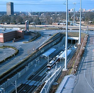
Richmond Heights station is a light rail station on the Blue Line of the St. Louis MetroLink system. This at-grade station is located near the interchange of Interstate 170 and Galleria Parkway in Richmond Heights, Missouri.
Brentwood I-64 station
Station in St. Louis MetroLink light rail system, Missouri, USA
Distance: Approx. 755 meters
Latitude and longitude: 38.628455,-90.33808
Brentwood I-64 station is a light rail station on the Blue Line of the St. Louis MetroLink system. This below-grade station is located near Eager Road in Brentwood, Missouri, just southeast of the Interstate 64/Interstate 170 interchange.
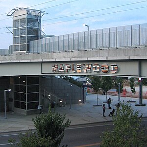
Maplewood–Manchester station
Station in St. Louis MetroLink light rail system, Missouri, USA
Distance: Approx. 1608 meters
Latitude and longitude: 38.614139,-90.331426
Maplewood–Manchester station is a light rail station on the Blue Line of the St. Louis MetroLink system. This station is located on an embankment near Manchester Road (Route 100) between South Hanley Road and Laclede Station Road in Maplewood, Missouri.

KFUO (AM)
Radio station in Clayton, Missouri, United States
Distance: Approx. 1645 meters
Latitude and longitude: 38.63830556,-90.31525
KFUO (850 kHz) is a non-commercial AM radio station licensed to Clayton, Missouri, U.S., and serving Greater St. Louis. It has a Christian radio format.

Missouri College
Distance: Approx. 555 meters
Latitude and longitude: 38.62724,-90.33558
Missouri College was a for-profit college in St. Louis, Missouri. Founded in 1963, the school was accredited by the Accrediting Council for Independent Colleges and Schools.

Maplewood Richmond Heights High School
Public high school in Maplewood, Missouri, United States
Distance: Approx. 1658 meters
Latitude and longitude: 38.614164,-90.324247
Maplewood Richmond Heights High School is a public high school in Maplewood, Missouri, United States.
Richmond Heights Memorial Library
Distance: Approx. 137 meters
Latitude and longitude: 38.62859444,-90.330975
The Richmond Heights Memorial Library is a public library in Richmond Heights, Missouri, a suburb of St. Louis. Established in 1933, the library holds more than 60,000 items.
Maplewood Public Library
Distance: Approx. 1580 meters
Latitude and longitude: 38.61463,-90.32554
The Maplewood Public Library is a public library in Maplewood, Missouri, a suburb of St. Louis. The library was established in 1935.
Hadley Township, St. Louis County, Missouri
Township in St. Louis County, Missouri, U.S.
Distance: Approx. 1003 meters
Latitude and longitude: 38.63305556,-90.31944444
Hadley Township is a township in St. Louis County, in the U.S. state of Missouri. Its population was 34,816 as of the 2010 census.

Oak Knoll Park
Distance: Approx. 1239 meters
Latitude and longitude: 38.63666667,-90.31972222
Oak Knoll Park is a municipal park in Clayton, Missouri, a suburb of St. Louis. Founded in 1958, it includes 14.5 acres of land that host one of the largest native stands of post oak trees.
Weather in this IP's area
smoke
18 Celsius
17 Celsius
17 Celsius
19 Celsius
1030 hPa
48 %
1030 hPa
1011 hPa
10000 meters
5.66 m/s
150 degree
20 %
07:13:47
18:18:36