Country:
Region:
City:
Latitude and Longitude:
Time Zone:
Postal Code:
IP information under different IP Channel
ip-api
Country
Region
City
ASN
Time Zone
ISP
Blacklist
Proxy
Latitude
Longitude
Postal
Route
Luminati
Country
Region
niz
City
nizhniynovgorod
ASN
Time Zone
Europe/Moscow
ISP
PJSC MegaFon
Latitude
Longitude
Postal
IPinfo
Country
Region
City
ASN
Time Zone
ISP
Blacklist
Proxy
Latitude
Longitude
Postal
Route
db-ip
Country
Region
City
ASN
Time Zone
ISP
Blacklist
Proxy
Latitude
Longitude
Postal
Route
ipdata
Country
Region
City
ASN
Time Zone
ISP
Blacklist
Proxy
Latitude
Longitude
Postal
Route
Popular places and events near this IP address

Nizhny Novgorod
City in Nizhny Novgorod Oblast, Russia
Distance: Approx. 749 meters
Latitude and longitude: 56.32694444,44.0075
Nizhny Novgorod ( NIZH-nee NOV-gə-rod; Russian: Нижний Новгород, IPA: [ˈnʲiʐnʲɪj ˈnovɡərət] , lit. 'Lower Newtown'; colloquially shortened to Nizhny) is the administrative centre of Nizhny Novgorod Oblast and the Volga Federal District in Russia. The city is located at the confluence of the Oka and the Volga rivers in Central Russia, with a population of over 1.2 million residents, up to roughly 1.7 million residents in the urban agglomeration.

Volga Federal District
Federal district of Russia
Distance: Approx. 102 meters
Latitude and longitude: 56.33333333,44
The Volga Federal District (Russian: Приволжский федеральный округ, IPA: [prʲɪˈvolʂskʲɪj fʲɪdʲɪˈralʲnɨj ˈokrʊk]) is one of the eight federal districts of Russia. It forms the southeastern part of European Russia. It is the second most populated federal district (after Central).

Kuzma Minin
Russian military leader (1570s–1616)
Distance: Approx. 491 meters
Latitude and longitude: 56.328309,44.001899
Kuzma Minin (Russian: Кузьма́ Ми́нин), full name Kuzma Minich Zakhariev-Sukhoruky (Russian: Кузьма́ Ми́нич Заха́рьев Сухору́кий; c. 1570s – May 21, 1616), was a Russian merchant who, together with Prince Dmitry Pozharsky, formed the popular uprising in Nizhny Novgorod against the Polish–Lithuanian Commonwealth's occupation of Russia during the Polish intervention in Russia (1605-1618) coinciding with the Time of Troubles. The popular uprising ultimately led to Russian victory at the Battle of Moscow and the end of Polish occupation in 1612. Minin and Pozharsky become national heroes in Russian culture and were honored in the Monument to Minin and Pozharsky in Moscow's Red Square.
Aleksandr Suvorov (ship)
Russian river cruise ship
Distance: Approx. 568 meters
Latitude and longitude: 56.33,44.009
Aleksandr Suvorov (Russian: Александр Суворов) is a Valerian Kuybyshev-class (92-016, OL400) Soviet/Russian river cruise ship, cruising in the Volga–Don basin. On 5 June 1983 Aleksandr Suvorov crashed into a girder of the Ulyanovsk railway bridge. The catastrophe led to 176 deaths yet the ship stayed afloat, was restored and still navigates.

Shukhov Rotunda
Distance: Approx. 102 meters
Latitude and longitude: 56.33333333,44
Shukhov Rotunda was a round exhibition pavilion built for All-Russia Exhibition 1896 in Nizhny Novgorod, Russia. It was built in 1896 with a diagrid hanging cover (tensile gridshell – diagrid roof, Russian Empire patent No. 1894, dated March 12, 1899) and was the world's first Hyperboloid structure (in the center of the Rotunda).
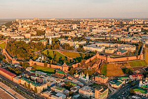
Nizhny Novgorod Kremlin
Fortress in Nizhny Novgorod
Distance: Approx. 475 meters
Latitude and longitude: 56.32850278,44.00256389
The Nizhny Novgorod Kremlin (Russian: Нижегородский кремль, romanized: Nizhegorodskiy kreml') is a fortress (kremlin) in the historic city center of Nizhny Novgorod, Russia.

Nizhny Novgorod Governorate
1714–1929 unit of Russia
Distance: Approx. 754 meters
Latitude and longitude: 56.3269,44.0075
Nizhny Novgorod Governorate was an administrative-territorial unit (guberniya) of the Russian Empire, Russian Republic, and the Russian SFSR, roughly corresponding to the Upper and Middle Volga region and what is now most of the Nizhny Novgorod Oblast. In the early 20th Century, Nizhny Novgorod Governorate bordered Kostroma and Vyatka governorates to the north, Vladimir Governorate to the west, Kazan and Simbirsk governorates to the east, and Penza with Tambov governorates to the south. In the early 18th Century, Nizhny Novgorod Governorate was included in Kazan Governorate, from 1708–1714, and 1717–1719.
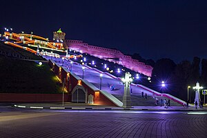
Chkalov Stairs
Staircase, a landmark of Nizhny Novgorod
Distance: Approx. 550 meters
Latitude and longitude: 56.33083333,44.00944444
The Chkalov Stairs is a monumental flight of steps in the center of Nizhny Novgorod, connecting Minin and Pozharsky Square, the Upper Volga and the Lower Volga embankments. It was built by the architects Alexander Yakovlev, Lev Rudnev and Vladimir Munts. It is the longest staircase in Russia.

Boldino Museum
Historic site in Nizhny Novgorod Oblast, Russia
Distance: Approx. 713 meters
Latitude and longitude: 56.32738528,44.0076365
Museum-reserve of Alexander Sergeevich Pushkin "Boldino" is a large Russian literary museum reserve, located in the complex of buildings of the family estate of Pushkin in the village of Bolshoye Boldino of the Nizhny Novgorod region, which is associated with one of the most fruitful periods of the poet's work, the "Boldino autumn" (September–November 1830).
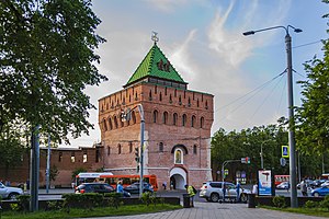
Dmitrievskaya Tower
Building in Nizhny Novgorod, Russia
Distance: Approx. 686 meters
Latitude and longitude: 56.327064,44.005697
The Dmitrievskaya Tower (Russian: Дмитриевская башня, romanized: Dmitrievskaya bashnya) is the main tower on the southern wall of the Nizhny Novgorod Kremlin which overlooks the Minin and Pozharsky Square. The tower named after a powerful Prince of Suzdal and Nizhny Novgorod Dmitry of Suzdal. Another version claims that the name gave a church which was sanctified of the name of Saint Demetrius of Thessaloniki.
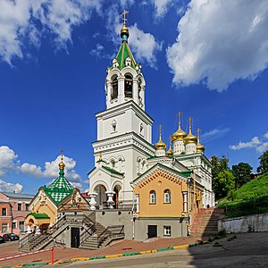
Church of St. John the Baptist (Nizhny Novgorod)
Church in Russia
Distance: Approx. 381 meters
Latitude and longitude: 56.32974722,43.99808889
The Church of St. John the Baptist is one of the oldest Orthodox churches in Nizhny Novgorod, mentioned from the 15th century. The stone church was consecrated in 1683, again on November 4, 2005.
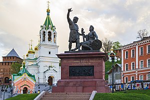
Monument to Minin and Pozharsky, Nizhny Novgorod
Sources added
Distance: Approx. 412 meters
Latitude and longitude: 56.329861,43.99692
The Monument to Minin and Pozharsky (Russian: Па́мятник Ми́нину и Пожа́рскому) is a copy of the monument erected on Red Square in Moscow. The monument is located in the historic centre of Nizhny Novgorod on National Unity Square, under the walls of the Kremlin, near the Church of St. John the Baptist.
Weather in this IP's area
overcast clouds
4 Celsius
-0 Celsius
4 Celsius
4 Celsius
1002 hPa
93 %
1002 hPa
994 hPa
10000 meters
6 m/s
220 degree
100 %
07:46:44
15:51:32
