128.136.218.139 - IP Lookup: Free IP Address Lookup, Postal Code Lookup, IP Location Lookup, IP ASN, Public IP
Country:
 USA
USARegion:
City:
Location:
Time Zone:
Postal Code:
ISP:
ASN:
language:
User-Agent:
Proxy IP:
Blacklist:
IP information under different IP Channel
ip-api
Country
Region
City
ASN
Time Zone
ISP
Blacklist
Proxy
Latitude
Longitude
Postal
Route
db-ip
Country
Region
City
ASN
Time Zone
ISP
Blacklist
Proxy
Latitude
Longitude
Postal
Route
IPinfo
Country
Region
City
ASN
Time Zone
ISP
Blacklist
Proxy
Latitude
Longitude
Postal
Route
IP2Location
128.136.218.139Country
usRegion
florida
City
palmetto
Time Zone
America/New_York
ISP
Language
User-Agent
Latitude
Longitude
Postal
ipdata
Country
Region
City
ASN
Time Zone
ISP
Blacklist
Proxy
Latitude
Longitude
Postal
Route
Popular places and events near this IP address
Ellenton, Florida
Census-designated place in Florida, United States
Distance: Approx. 3165 meters
Latitude and longitude: 27.52277778,-82.52583333
Ellenton is an unincorporated community and census-designated place (CDP) in Manatee County, Florida, United States. The population was 4,129 at the 2020 census, down from 4,275 at the 2010 census. It is part of the North Port-Bradenton-Sarasota, Florida Metropolitan Statistical Area.

Memphis, Florida
Census-designated place in Florida, United States
Distance: Approx. 1192 meters
Latitude and longitude: 27.53972222,-82.56305556
Memphis is an unincorporated community and census-designated place (CDP) in Manatee County, Florida, United States. The population was 9,024 as of the 2020 census, up from 7,848 in 2010. It is part of the North Port–Bradenton–Sarasota, Florida Metropolitan Statistical Area.
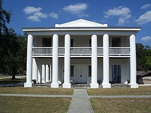
Gamble Plantation Historic State Park
Florida State Park in Ellenton, Florida
Distance: Approx. 1913 meters
Latitude and longitude: 27.53333333,-82.53333333
The Judah P. Benjamin Confederate Memorial at Gamble Plantation Historic State Park, also known as the Gamble Mansion or Gamble Plantation, is a Florida State Park, located in Ellenton, Florida, on 37th Avenue East and US 301. It is home to the Florida Division United Daughters of the Confederacy (UDC). The park consists of the antebellum mansion developed by its first owner, Major Robert Gamble; a 40,000-gallon cistern to provide the household with fresh water; and 16 acres (65,000 m2) of the former sugarcane plantation.

Palmetto High School (Florida)
High school in Palmetto, Florida, United States
Distance: Approx. 2855 meters
Latitude and longitude: 27.5297598,-82.5773193
Palmetto High School, a high school located in Palmetto, Florida was originally opened in 1957 and rebuilt in 1999. The school's athletic teams are known as the Tigers, and the school colors are red, white, and black. The school currently serves students in grades 9 through 12.

WBRD
Radio station in Palmetto, Florida
Distance: Approx. 2370 meters
Latitude and longitude: 27.545,-82.57444444
WBRD (1420 AM) is a radio station broadcasting a Regional Mexican format. Licensed to Palmetto, Florida, United States, the station serves the Bradenton area. The station is owned by Birach Broadcasting Corporation.

Bradenton Area Convention Center
Arena in Florida, United States
Distance: Approx. 3026 meters
Latitude and longitude: 27.514932,-82.561719
Bradenton Area Convention Center, formerly Manatee Civic Center, is a 4,000-seat multi-purpose arena and convention center in Palmetto, Florida. It was home to the Florida Stingers of the Continental Basketball Association and Florida Scorpions of the American Professional Football League. It also hosted UWF's first and only live pay-per-view event, Beach Brawl, on June 9, 1991.
Manatee School for the Arts
School in Palmetto, Florida, United States
Distance: Approx. 2597 meters
Latitude and longitude: 27.517095,-82.5498882
Manatee School for the Arts is a public charter school in Palmetto, Florida enrolling middle school and high school students.
Memphis Heights, Florida
Unincorporated community in Florida, U.S.
Distance: Approx. 520 meters
Latitude and longitude: 27.53666667,-82.55416667
Memphis Heights is an unincorporated area in Manatee County, Florida, United States.
Palm View, Florida
Unincorporated community in Florida, United States
Distance: Approx. 3195 meters
Latitude and longitude: 27.56861111,-82.55694444
Palm View is an unincorporated area in Manatee County, Florida, United States. The area is located north of the Manatee River.
Manavista, Florida
Unincorporated community in Florida, United States
Distance: Approx. 3171 meters
Latitude and longitude: 27.51555556,-82.53527778
Manavista was an area surrounded by the Atwood Grape Fruit Company. The brief history of Manavista began when Kimball C. Atwood (1853-1934) purchased 265 acres of land that was situated a mile east of the city of Palmetto on the north side of the Manatee River in 1892. The grove consisted of about 96 rows of grapefruit trees.
Palmetto Estuary Preserve
Nature preserve in Florida, United States
Distance: Approx. 3328 meters
Latitude and longitude: 27.51277778,-82.56388889
Palmetto Estuary Preserve (or Palmetto Estuary Park) is a 20-acre (8.1 ha) preserve in Palmetto, Florida. The preserve is located directly north of the Hernando de Soto Bridge and abuts the Manatee River.
Lincoln Memorial High School
Florida high school
Distance: Approx. 1697 meters
Latitude and longitude: 27.5284,-82.5616
Lincoln Memorial High School, established as Lincoln Academy Grammar School, was the only public high school for African Americans in Manatee County, Florida prior to desegregation. Located in Palmetto, Florida, it was originally established as Lincoln Academy in 1930, making it Manatee County's first school for blacks. In 1949, Lincoln Academy was merged with Memorial High School, becoming Lincoln Memorial High School.
Weather in this IP's area
scattered clouds
21 Celsius
22 Celsius
20 Celsius
23 Celsius
1017 hPa
94 %
1017 hPa
1016 hPa
10000 meters
5.36 m/s
7.15 m/s
103 degree
40 %