Country:
Region:
City:
Latitude and Longitude:
Time Zone:
Postal Code:
IP information under different IP Channel
ip-api
Country
Region
City
ASN
Time Zone
ISP
Blacklist
Proxy
Latitude
Longitude
Postal
Route
Luminati
Country
Region
15
City
joetsu
ASN
Time Zone
Asia/Tokyo
ISP
Joetsu Cable Vision
Latitude
Longitude
Postal
IPinfo
Country
Region
City
ASN
Time Zone
ISP
Blacklist
Proxy
Latitude
Longitude
Postal
Route
db-ip
Country
Region
City
ASN
Time Zone
ISP
Blacklist
Proxy
Latitude
Longitude
Postal
Route
ipdata
Country
Region
City
ASN
Time Zone
ISP
Blacklist
Proxy
Latitude
Longitude
Postal
Route
Popular places and events near this IP address

Kasugayama Castle
Sengoku period yamashiro-style Japanese castle located in Niigata prefecture
Distance: Approx. 4231 meters
Latitude and longitude: 37.147108,138.205597
Kasugayama Castle (春日山城, Kasugayama-jō) is a Sengoku period yamashiro-style Japanese castle located in the Nakayashiki neighborhood of the city of Jōetsu, Niigata prefecture. It was the primary fortress of the warlord Uesugi Kenshin, and was originally built and ruled by the Nagao clan. It is listed as one of Japan's Top 100 Castles and the ruins have been protected as a National Historic Site since 1935.

Jōetsu, Niigata
Special city in Chūbu, Japan
Distance: Approx. 2217 meters
Latitude and longitude: 37.14786111,138.23608333
Jōetsu (上越市, Jōetsu-shi) is a city located in Niigata Prefecture, Japan. As of 1 December 2020, the city had an estimated population of 189,430, in 76,461 households with a population density of 190 persons per km2. The total area of the city was 973.81 square kilometres (375.99 sq mi).

Naoetsu Station
Railway station in Jōetsu, Niigata Prefecture, Japan
Distance: Approx. 694 meters
Latitude and longitude: 37.171021,138.243113
Naoetsu Station (直江津駅, Naoetsu-eki) is a railway station in the city of Jōetsu, Niigata, Japan, jointly operated by East Japan Railway Company (JR East) and the third-sector railway operator Echigo Tokimeki Railway.

Kuroi Station (Niigata)
Railway station in Jōetsu, Niigata Prefecture, Japan
Distance: Approx. 2687 meters
Latitude and longitude: 37.18361111,138.2675
Kuroi Station (黒井駅, Kuroi-eki) is a railway station on the Shinetsu Main Line in the city of Jōetsu, Niigata, Japan, operated by East Japan Railway Company (JR East). The station also has a freight terminal operated by Japan Freight Railway Company (JR Freight).

Joetsu University of Education
National university in Joetsu, Niigata, Japan
Distance: Approx. 3771 meters
Latitude and longitude: 37.13694444,138.22472222
Joetsu University of Education (上越教育大学, Jōetsu Kyōiku Daigaku) is a national university in Joetsu, Niigata, Japan, founded in 1978.

Takada Station (Niigata)
Railway station in Jōetsu, Niigata Prefecture, Japan
Distance: Approx. 5661 meters
Latitude and longitude: 37.115,138.24222222
Takada Station (高田駅, Takada-eki) is a railway station in the city of Jōetsu, Niigata, Japan, operated by the third-sector operator Echigo Tokimeki Railway.
Kasugayama Station
Railway station in Jōetsu, Niigata Prefecture, Japan
Distance: Approx. 2238 meters
Latitude and longitude: 37.1481,138.235
Kasugayama Station (春日山駅, Kasugayama-eki) is a railway station on the Echigo Tokimeki Railway Myōkō Haneuma Line in the city of Jōetsu, Niigata, Japan operated by the third-sector operator Echigo Tokimeki Railway.

Shozenji Dam
Dam in Niigata Prefecture, Japan
Distance: Approx. 6185 meters
Latitude and longitude: 37.145,138.1825
Shozenji Dam (Japanese: 正善寺ダム) is a dam in the Niigata Prefecture, Japan, completed in 1984.
Kota Shrine (Niigata)
Distance: Approx. 2130 meters
Latitude and longitude: 37.16647778,138.22319444
Kota Shrine (居多神社, Kota-jinja) is a Shinto shrine located in the Gochi neighborhood of the city of Jōetsu, Niigata Prefecture. It is one of the three shrines claiming the title of ichinomiya of former Echigo Province. The main festival of the shrine is held annually on May 3.

Seki River
River in Honshu, Japan
Distance: Approx. 1859 meters
Latitude and longitude: 37.18239,138.2465
The Seki River (関川) is a Class A river in Niigata Prefecture and Nagano Prefecture, Japan. Approximately 210,000 people live in the basin area.

Region Plaza Joetsu
Distance: Approx. 1312 meters
Latitude and longitude: 37.15441667,138.25144444
Region Plaza Joetsu is the multi-purpose facilities in Jōetsu, Niigata, Japan.
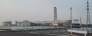
Jōetsu Thermal Power Station
Distance: Approx. 5116 meters
Latitude and longitude: 37.20508333,138.27691667
Jōetsu Thermal Power Station (上越火力発電所, Jōetsu Karyoku Hatsudensho) is an LNG-fired thermal power station operated by JERA in the city of Jōetsu, Niigata, Japan. The facility is located on reclaimed land on the Sea of Japan.
Weather in this IP's area
clear sky
12 Celsius
12 Celsius
12 Celsius
12 Celsius
1030 hPa
75 %
1030 hPa
1030 hPa
10000 meters
2.16 m/s
2.7 m/s
317 degree
5 %
06:18:30
16:43:03


