Country:
Region:
City:
Latitude and Longitude:
Time Zone:
Postal Code:
IP information under different IP Channel
ip-api
Country
Region
City
ASN
Time Zone
ISP
Blacklist
Proxy
Latitude
Longitude
Postal
Route
Luminati
Country
Region
vic
City
melbourne
ASN
Time Zone
Australia/Melbourne
ISP
Macquarie Technology Operations Pty Limited
Latitude
Longitude
Postal
IPinfo
Country
Region
City
ASN
Time Zone
ISP
Blacklist
Proxy
Latitude
Longitude
Postal
Route
db-ip
Country
Region
City
ASN
Time Zone
ISP
Blacklist
Proxy
Latitude
Longitude
Postal
Route
ipdata
Country
Region
City
ASN
Time Zone
ISP
Blacklist
Proxy
Latitude
Longitude
Postal
Route
Popular places and events near this IP address

City of Gosnells
Local government area in Perth, Western Australia
Distance: Approx. 2021 meters
Latitude and longitude: -32.072,115.995
The City of Gosnells is a local government area in the southeastern suburbs of the Western Australian capital city of Perth, located northwest of Armadale and about 20 kilometres (12 mi) southeast of Perth's central business district. The City covers an area of 128 square kilometres (49.42 sq mi), a portion of which is state forest rising into the Darling Scarp to the east, and had a population of approximately 118,000 at the 2016 Census. The largest activity centre in the City is the Central Maddington shopping centre.

Gosnells railway station
Railway station in Perth, Western Australia
Distance: Approx. 2381 meters
Latitude and longitude: -32.073675,116.003013
Gosnells railway station is located on the South Western Railway 21 kilometres from Perth Station in the suburb of Gosnells. It is served by Armadale Line services which are part of the Transperth network.

Maddington railway station
Railway station in Perth, Western Australia
Distance: Approx. 1105 meters
Latitude and longitude: -32.049611,115.982843
Maddington railway station is on the Transperth network. It is located on the Armadale Line, 17.7 kilometres from Perth Station serving the suburb of Maddington.
Maddington, Western Australia
Suburb of Perth, Western Australia
Distance: Approx. 633 meters
Latitude and longitude: -32.049,115.99
Maddington is a suburb 20 kilometres (12 mi) southeast of the central business district of Perth, the capital of Western Australia, within the City of Gosnells local government area. Maddington is a mixed-use suburb containing major residential, retail and industrial sections as well as some semi-rural areas. Unusual amongst the surrounding suburbs Maddington still retains several vineyards and orchards from when the locality was used for agricultural purposes.

East Metropolitan Region
Electoral region in Perth, Western Australia
Distance: Approx. 1435 meters
Latitude and longitude: -32.06,115.98
The East Metropolitan Region is a multi-member electoral region of the Western Australian Legislative Council, located in the eastern and south-eastern suburbs of Perth. It was created by the Acts Amendment (Electoral Reform) Act 1987, and became effective on 22 May 1989 with five members who had been elected at the 1989 state election three months earlier. At the 2008 election, it was increased to six members.

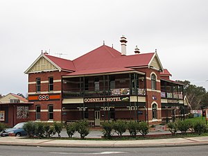
Gosnells, Western Australia
Suburb of Perth, Western Australia
Distance: Approx. 2021 meters
Latitude and longitude: -32.072,115.995
Gosnells is a suburb located within the City of Gosnells. Gosnells is approximately 20 kilometres (12 mi) south-east of the Perth central business district. It contains the Gosnells town centre which includes the Council offices, library and the Gosnells Railway Station.
Heritage FM
Radio station in Gosnells
Distance: Approx. 1624 meters
Latitude and longitude: -32.0669,116.0012
107.3 HFM (call sign: 6HFM) is a community radio station that broadcasts on 107.3 MHz FM from its studios at 44 Mills Road West in Gosnells, Western Australia. It broadcasts a wide range of locally produced music and information programs. The station commenced broadcasting on 26 January 1998 from studios in Orchard Avenue, Armadale, Western Australia on the 93.7 MHz FM frequency and continued on that frequency until it switched to its current 107.3 MHz FM frequency in 2002.

Electoral district of Thornlie
State electoral district of Perth, Western Australia
Distance: Approx. 2310 meters
Latitude and longitude: -32.06,115.97
Thornlie is an electoral district of the Legislative Assembly of Western Australia. It is located in Perth's southeastern suburbs, and is named after the suburb of Thornlie. Thornlie was first created for the 1989 state election.
Rehoboth Christian College
School in Australia
Distance: Approx. 2614 meters
Latitude and longitude: -32.03361111,115.97944444
Rehoboth Christian College is a dual-campus independent trans-denominational Protestant co-educational primary and secondary day school, located in the south-eastern corridor of Perth, Western Australia. The college comprises a Year K to Year 6 campus in the suburb of Wilson, and a Year K to Year 12 campus in the suburb of Kenwick. The college currently enrols some 1000 students across its two campuses.
Yule Brook College
School in Perth, Western Australia
Distance: Approx. 1547 meters
Latitude and longitude: -32.048445,116.008485
Yule Brook College is a public co-educational middle day school, located on Dellar Road in Maddington, a suburb of Perth, Western Australia.
Lumen Christi College, Perth
School in Perth, Western Australia
Distance: Approx. 2670 meters
Latitude and longitude: -32.07025,116.01411111
Lumen Christi College is an independent Roman Catholic coeducational secondary day school, located the Perth south-eastern suburb of Martin, Western Australia. The school provides a religious and general education to students from Year 7 to Year 12. The school has five houses, Campbell, Mackillop, Salvado, Tangney & Yagan.

Kenwick Pioneer Cemetery
Heritage site and cemetery in Kenwick, Western Australia
Distance: Approx. 2324 meters
Latitude and longitude: -32.04222,115.97298
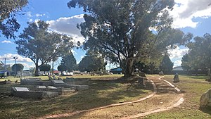
Kenwick Pioneer Cemetery is located in Kenwick, Western Australia adjacent to Albany Highway. It is part of the 1.2 hectares (3 acres) of land donated by Wallace Bickley for a school for the children of the Canning in 1863. In 1865 a rammed earth building with shingle roof was constructed by convicts.
Weather in this IP's area
overcast clouds
18 Celsius
18 Celsius
17 Celsius
19 Celsius
1020 hPa
61 %
1020 hPa
1018 hPa
10000 meters
4.63 m/s
110 degree
100 %
05:11:53
18:47:54