125.254.81.94 - IP Lookup: Free IP Address Lookup, Postal Code Lookup, IP Location Lookup, IP ASN, Public IP
Country:
Region:
City:
Location:
Time Zone:
Postal Code:
IP information under different IP Channel
ip-api
Country
Region
City
ASN
Time Zone
ISP
Blacklist
Proxy
Latitude
Longitude
Postal
Route
Luminati
Country
Region
wa
City
perth
ASN
Time Zone
Australia/Perth
ISP
Anycast Global Backbone
Latitude
Longitude
Postal
IPinfo
Country
Region
City
ASN
Time Zone
ISP
Blacklist
Proxy
Latitude
Longitude
Postal
Route
IP2Location
125.254.81.94Country
Region
western australia
City
perth
Time Zone
Australia/Perth
ISP
Language
User-Agent
Latitude
Longitude
Postal
db-ip
Country
Region
City
ASN
Time Zone
ISP
Blacklist
Proxy
Latitude
Longitude
Postal
Route
ipdata
Country
Region
City
ASN
Time Zone
ISP
Blacklist
Proxy
Latitude
Longitude
Postal
Route
Popular places and events near this IP address
Perth railway station
Railway station in Perth, Western Australia
Distance: Approx. 139 meters
Latitude and longitude: -31.95138889,115.86027778
Perth railway station is the largest station on the Transperth network, serving the central business district of Perth, Western Australia. It serves as an interchange between the Airport, Armadale, Ellenbrook, Fremantle, Midland, and Thornlie lines as well as Transwa's Australind service. It is also directly connected to Perth Underground railway station, which has the Yanchep and Mandurah lines.

Horseshoe Bridge
Bridge in Perth, Western Australia
Distance: Approx. 244 meters
Latitude and longitude: -31.950854,115.859361
The Horseshoe Bridge in Perth, Western Australia is a traffic bridge that connects the Perth CBD to Northbridge, carrying William Street. It was constructed in 1904 to pass over the Fremantle railway line, with the horseshoe shape designed to fit the approach ramps into a constricted site.

Art Gallery of Western Australia
Public art gallery in Perth, Western Australia
Distance: Approx. 185 meters
Latitude and longitude: -31.950588,115.860943
The Art Gallery of Western Australia (AGWA) is a public art gallery that is part of the Perth Cultural Centre, in Perth. It is located near the Western Australian Museum and State Library of Western Australia and is supported and managed by the Department of Local Government, Sport and Cultural Industries of the Government of Western Australia. The current gallery main building opened in 1979.

Forrest Chase
Shopping complex in Perth, Western Australia
Distance: Approx. 139 meters
Latitude and longitude: -31.95257,115.85999
Forrest Chase is a major shopping centre in Perth, Western Australia located in Forrest Place. A Myer store serves as its main anchor and largest tenant. The centre also contains a Woolworths supermarket and other shops.
Awesome Festival
Arts festival in Perth, Western Australia
Distance: Approx. 237 meters
Latitude and longitude: -31.95222222,115.85888889
The Awesome Festival (in full the Awesome International Arts Festival for Bright Young Things) is an arts event in Perth, Western Australia held annually since 1995. The participation and interaction of younger visitors is encouraged by street theatre, interactive art, dance workshops, film screenings and musical performances. It is organised and run by Awesome Arts Australia, a not-for-profit company based in Perth.
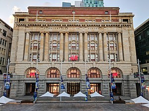
General Post Office, Perth
Post office in Western Australia, Australia
Distance: Approx. 227 meters
Latitude and longitude: -31.9522,115.859
The General Post Office is a heritage landmark building in Perth, Western Australia. Located on the western side of Forrest Place in the city's central business district, its imposing stone facade is in the Beaux-Arts style. The building was completed in 1923 after almost a decade of construction, which was protracted by World War I and the resulting shortages of construction materials.
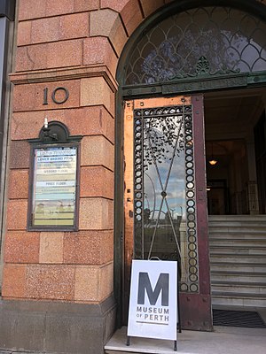
Museum of Perth
Museum in Perth, Western Australia
Distance: Approx. 225 meters
Latitude and longitude: -31.95416667,115.86083333
The Museum of Perth is a private, non-profit museum involved with chronicling the social, cultural, political and architectural history of Perth. The museum is currently, as of 2024, located in a former telephone exchange building on Murray Street, in Perth, Western Australia. In 2016 the museum was housed in the Atlas Building, on the Esplanade.
Grand Theatre, Perth
Former theatre and cinema in Perth, Western Australia
Distance: Approx. 101 meters
Latitude and longitude: -31.952716,115.860522
The Grand Theatre was a theatre and cinema located at 164–168 Murray Street, Perth, Western Australia. It was opened in September 1916 and closed in November 1980. The building was demolished in March 1990.
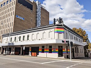
Court Hotel
Heritage-listed hotel in Perth, Western Australia
Distance: Approx. 238 meters
Latitude and longitude: -31.95027,115.86249
Court Hotel or The Court is a music venue and bar in Perth, Western Australia. It is an historic hotel, located at the corner of Beaufort Street and James Street. It was built in 1888 and has been continually used as a hotel since then.
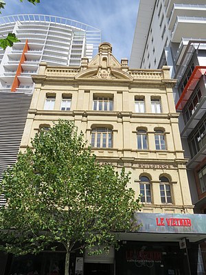
Bon Marché Arcade
Heritage listed building in Perth, Western Australia
Distance: Approx. 234 meters
Latitude and longitude: -31.95424,115.860797
Bon Marché Arcade, also known as Bon Marché Buildings, is a heritage-listed building in Perth, Western Australia], located at 74–84 Barrack Street in the Perth central business district. It is three and four storeys tall, built in 1901 from brick in the Federation Free Classical architectural style, with a tin roof. Designed by architect H. J. Prockter, it was a prominent feature in Barrack Street when constructed, being taller than the one or two story buildings surrounding it.
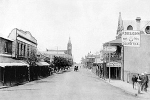
Phineas Seeligson's
Heritage listed building in Perth, Western Australia
Distance: Approx. 53 meters
Latitude and longitude: -31.95254,115.861
Phineas Seeligson's is a heritage-listed building in Perth, Western Australia. Located at 143 Barrack Street in the city's central business district, it has also been known as Toastface, and Atomic Sky as Studio StartUp.

Commonwealth Bank building, Perth
Heritage listed building in Perth, Western Australia
Distance: Approx. 227 meters
Latitude and longitude: -31.9522,115.859
The Commonwealth Bank Building is a heritage building in Perth, Western Australia, on the western side of Forrest Place in the city's central business district. It was built in 1933, some ten years after the creation of the Forrest Place road between Murray Street and Wellington Street in 1923.
Weather in this IP's area
clear sky
25 Celsius
24 Celsius
24 Celsius
26 Celsius
1016 hPa
31 %
1016 hPa
1012 hPa
10000 meters
6.17 m/s
110 degree
