Country:
 Australia
Region:
City:
Latitude and Longitude:
Time Zone:
Postal Code:
IP information under different IP Channel
ip-api
Country
Region
City
ASN
Time Zone
ISP
Blacklist
Proxy
Latitude
Longitude
Postal
Route
IPinfo
Country
Region
City
ASN
Time Zone
ISP
Blacklist
Proxy
Latitude
Longitude
Postal
Route
MaxMind
Country
Region
City
ASN
Time Zone
ISP
Blacklist
Proxy
Latitude
Longitude
Postal
Route
Luminati
Country
AURegion
nsw
City
sydney
ASN
Time Zone
Australia/Sydney
ISP
Virtutel Pty Ltd
Latitude
Longitude
Postal
db-ip
Country
Region
City
ASN
Time Zone
ISP
Blacklist
Proxy
Latitude
Longitude
Postal
Route
ipdata
Country
Region
City
ASN
Time Zone
ISP
Blacklist
Proxy
Latitude
Longitude
Postal
Route
Popular places and events near this IP address

Division of Barton
Australian federal electoral division
Distance: Approx. 1069 meters
Latitude and longitude: -33.956,151.129
The Division of Barton is an Australian electoral division in the state of New South Wales.

Sydney Technical High School
School in Australia
Distance: Approx. 1445 meters
Latitude and longitude: -33.96277778,151.11444444
Sydney Technical High School (STHS) is a state-financed single-sex academically selective secondary day school for boys, located in Bexley, a southern suburb of Sydney situated near the city. Founded in 1911 as part of Sydney Technical College, the school was one of the six original New South Wales selective schools and caters for boys from Year 7 to Year 12. The school is colloquially abbreviated to Sydney Tech, STHS or simply Tech.

Bexley North railway station
Railway station in Sydney, New South Wales, Australia
Distance: Approx. 1560 meters
Latitude and longitude: -33.937499,151.113194
Bexley North railway station is a heritage-listed railway station located on the East Hills line, serving the Sydney suburb of Bexley North. It is served by Sydney Trains' T8 Airport & South Line services.

Rockdale railway station
Railway station in Sydney, New South Wales, Australia
Distance: Approx. 1593 meters
Latitude and longitude: -33.952051,151.136658
Rockdale railway station is a heritage-listed railway station located on the Illawarra line, serving the Sydney suburb of Rockdale in Bayside Council. It is served by Sydney Trains' T4 Eastern Suburbs & Illawarra Line services. It was added to the New South Wales State Heritage Register on 2 April 1999.

Bexley North, New South Wales
Suburb of Sydney, New South Wales, Australia
Distance: Approx. 1237 meters
Latitude and longitude: -33.94166667,151.11138889
Bexley North is a suburb in southern Sydney, in the state of New South Wales, Australia, 13 kilometres (8.1 miles) south-west of the Sydney CBD. It is part of the St George area. Bexley North is in the local government area of the Bayside Council.

Bexley, New South Wales
Suburb of Sydney, New South Wales, Australia
Distance: Approx. 918 meters
Latitude and longitude: -33.95666667,151.12611111
Bexley is a suburb in southern Sydney, in the state of New South Wales, Australia. Bexley is located 14 kilometres (8.7 mi) south-west of the Sydney central business district, in the local government area of the Bayside Council and is part of the St George area.

Marist College Kogarah
Secondary school in Sydney, Australia
Distance: Approx. 1302 meters
Latitude and longitude: -33.95805556,151.13027778
Marist College Kogarah is an independent Roman Catholic single sex secondary day school for boys, located in Bexley, a suburb located in the St George region of Sydney, New South Wales, Australia. The college was founded in 1909, and has a tradition based on the teachings of the French educator Saint Marcellin Champagnat, the founder of the Marist Brothers. The school offers education to approximately 1,200 students from Year 7 to Year 12.

Parish of St George
Cadastral in New South Wales, Australia
Distance: Approx. 1716 meters
Latitude and longitude: -33.94833333,151.10111111
St George Parish is one of the 57 parishes of Cumberland County, New South Wales, a cadastral unit for use on land titles. It is bounded in the north by the Cooks River, in the west by Cox's Creek and Salt Pan Creek, and in the south by the Georges River and in the east by Botany Bay. The parish covers the local government area of Georges River Council (in the southeast), the western part of Bayside Council (formerly the City of Rockdale) in the northeast, and the eastern part of the City of Canterbury-Bankstown (formerly the City of Canterbury) in the north.
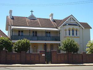
Bethany College (Sydney)
School in Australia
Distance: Approx. 1390 meters
Latitude and longitude: -33.96166667,151.11277778
Bethany College is an independent Roman Catholic comprehensive single-sex secondary day school for girls, located in Hurstville, a southern suburb in Sydney, Australia. In 2009 Bethany Junior and Senior campuses amalgamated into one campus in Hurstville. It is located directly across Sydney Technical High School on Forest Road.

Bardwell Creek
Watercourse in Sydney, New South Wales, Australia
Distance: Approx. 268 meters
Latitude and longitude: -33.95,151.11666667
Bardwell Creek, an urban watercourse of the Cooks River catchment, is located in the southern suburbs of Sydney, in New South Wales, Australia.

Kingsgrove North High School
School in Kingsgrove, New South Wales, Australia
Distance: Approx. 1706 meters
Latitude and longitude: -33.9475,151.10138889
Kingsgrove North High School (abbreviated as KNHS) is a co-educational public high school located in Kingsgrove, New South Wales, Australia and founded in 1959. The school is part of the St. George Region of high schools and is administered by the New South Wales Department of Education.
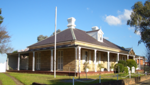
Lydham Hall
Historic site in New South Wales, Australia
Distance: Approx. 1160 meters
Latitude and longitude: -33.9449,151.1301
Lydham Hall is a state heritage-listed former rural residence at 18 Lydham Avenue, Rockdale in New South Wales, Australia. The house is currently used as a local museum holding a collection of furniture and objects dated from the 1860s. Run by the St George Historical Society, it is opened to the public on the first Sunday of every month.
Weather in this IP's area
broken clouds
15 Celsius
14 Celsius
13 Celsius
15 Celsius
1024 hPa
75 %
1024 hPa
1017 hPa
10000 meters
8.75 m/s
170 degree
75 %
06:23:00
19:02:54