Country:
 Australia
Region:
City:
Latitude and Longitude:
Time Zone:
Postal Code:
IP information under different IP Channel
ip-api
Country
Region
City
ASN
Time Zone
ISP
Blacklist
Proxy
Latitude
Longitude
Postal
Route
IPinfo
Country
Region
City
ASN
Time Zone
ISP
Blacklist
Proxy
Latitude
Longitude
Postal
Route
MaxMind
Country
Region
City
ASN
Time Zone
ISP
Blacklist
Proxy
Latitude
Longitude
Postal
Route
Luminati
Country
 SG
SGCity
singapore
ASN
Time Zone
Asia/Singapore
ISP
PhoenixNAP
Latitude
Longitude
Postal
db-ip
Country
Region
City
ASN
Time Zone
ISP
Blacklist
Proxy
Latitude
Longitude
Postal
Route
ipdata
Country
Region
City
ASN
Time Zone
ISP
Blacklist
Proxy
Latitude
Longitude
Postal
Route
Popular places and events near this IP address

Point Cook, Victoria
Suburb of Melbourne, Victoria, Australia
Distance: Approx. 984 meters
Latitude and longitude: -37.909,144.752
Point Cook is a suburb in Melbourne, Victoria, Australia, 22 km (14 mi) south-west of Melbourne's Central Business District, located within the City of Wyndham local government area. Point Cook recorded a population of 66,781 at the 2021 census. Point Cook is the home of RAAF Base Point Cook, the birthplace of the Royal Australian Air Force, and is the current home of the RAAF Museum.

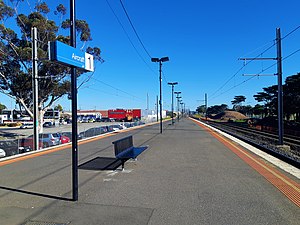
Laverton railway station, Melbourne
Railway station in Laverton, Melbourne, Victoria, Australia
Distance: Approx. 4367 meters
Latitude and longitude: -37.8638,144.7722
Laverton railway station is a commuter railway station on the Werribee line, which is part of the Melbourne railway network. It serves the western suburb of Laverton in Melbourne, Victoria, Australia. Laverton station is a ground level premium station, featuring three platforms, an island platform with two faces and one side platform.
Aircraft railway station
Railway station in Victoria, Australia
Distance: Approx. 3800 meters
Latitude and longitude: -37.8666,144.7609
Aircraft railway station is a commuter railway station on the Werribee line, which is part of the Melbourne railway network. It serves the western suburb of Laverton, in Melbourne, Victoria, Australia. Aircraft station is a ground level unstaffed station, featuring an island platform.

Altona Meadows, Victoria
Suburb of Melbourne, Victoria, Australia
Distance: Approx. 3739 meters
Latitude and longitude: -37.875,144.782
Altona Meadows is a suburb in Melbourne, Victoria, Australia, 17 km (11 mi) south-west of Melbourne's Central Business District, located within the City of Hobsons Bay local government area. Altona Meadows recorded a population of 18,479 at the 2021 census. Located partly within Altona Meadows, Cheetham Wetlands is a large park with numerous boardwalks traversing its network of lagoons.

RAAF Williams
Australian military air base
Distance: Approx. 3492 meters
Latitude and longitude: -37.93166667,144.75333333
RAAF Williams (ICAO: YMPC) is a Royal Australian Air Force (RAAF) military air base set across two locations, at Point Cook and Laverton, located approximately 20 km (12 mi) south-west of the Melbourne central business district in Victoria, Australia. Both establishments previously existed as separate RAAF Bases (RAAF Base Point Cook and RAAF Base Laverton) until 1989 when they were amalgamated to form RAAF Williams. The name was chosen in honour of Air Marshal Sir Richard Williams, the 'father' of the RAAF. RAAF Williams, Point Cook is the birthplace of the Royal Australian Air Force and is the oldest continually operating military airfield in the world.
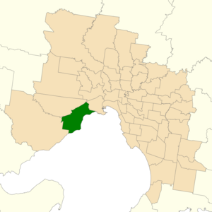
Electoral district of Altona
State electoral district of Victoria, Australia
Distance: Approx. 3195 meters
Latitude and longitude: -37.88333333,144.78333333
The electoral district of Altona was one of the electoral districts of Victoria, Australia, for the Victorian Legislative Assembly. It covered an area of 79 square kilometres (31 sq mi) in western Melbourne, and included the suburbs of Altona, Altona Meadows, Laverton, Point Cook, Seabrook and Seaholme. It also included the RAAF Williams airbase and the Point Cook Coastal Park.

Seabrook, Victoria
Suburb of Melbourne, Victoria, Australia
Distance: Approx. 2728 meters
Latitude and longitude: -37.876,144.758
Seabrook is a suburb in Melbourne, Victoria, Australia, 19 km (12 mi) south-west of Melbourne's Central Business District, located within the City of Hobsons Bay local government area. Seabrook recorded a population of 4,952 at the 2021 census.

RAAF Museum
Military museum in RAAF Williams Point Cook
Distance: Approx. 3386 meters
Latitude and longitude: -37.930464,144.749073
RAAF Museum is the official museum of the Royal Australian Air Force located at RAAF Williams Point Cook, Victoria, Australia. The museum displays aircraft of significance to the RAAF from its inception as the Australian Flying Corps to the present.

Point Cook Town Centre
Shopping mall in Victoria, Australia
Distance: Approx. 2426 meters
Latitude and longitude: -37.88388889,144.73583333
Point Cook Town Centre is a shopping centre in the centre of Point Cook in the west of Melbourne, Victoria, Australia. It currently contains 150 stores in total and three supermarkets, Coles, Woolworths and Aldi, as well as a Target department store. Although the official name the centre is Stockland Point Cook, it is known locally as Point Cook Town Centre.

Williams Landing railway station
Railway station in Melbourne, Australia
Distance: Approx. 3399 meters
Latitude and longitude: -37.87027778,144.74694444
Williams Landing railway station is a commuter railway station on the Werribee line, which is part of the Melbourne railway network. It serves the western suburb of Williams Landing, in Melbourne, Victoria, Australia. Williams Landing station is a ground level premium station, featuring an island platform.

Cheetham Wetlands
Wetlands at Port Phillip Bay, Victoria, Australia
Distance: Approx. 3650 meters
Latitude and longitude: -37.895,144.795
The Cheetham Wetlands are 420 hectares of artificial and natural lagoons, created on old salt works land on the western shores of Port Phillip Bay, Australia. The wetlands are approximately 20 kilometres (12 mi) southwest of Melbourne, and sit within the Municipal Councils of Hobsons Bay and Wyndham City. The wetlands are part of the Point Cook Coastal Park and are crown land for conservation purposes.
Point Cook Coastal Park
Protected area in Victoria, Australia
Distance: Approx. 726 meters
Latitude and longitude: -37.90555556,144.75888889
The Point Cook Coastal Park covers an area of 863 hectares (2,130 acres) and includes the Cheetham Wetlands. The park extends from the RAAF Williams Point Cook Base northeast along the coast to the Laverton creek which comprises its northern boundary. The park is approximately 20 kilometres (12 mi) from Melbourne, Australia in a southwesterly direction along Port Phillip Bay.
Weather in this IP's area
clear sky
17 Celsius
17 Celsius
16 Celsius
19 Celsius
1018 hPa
74 %
1018 hPa
1017 hPa
10000 meters
2.68 m/s
5.36 m/s
159 degree
3 %
06:29:58
19:41:38