Country:
 Indonesia
Region:
City:
Latitude and Longitude:
Time Zone:
Postal Code:
IP information under different IP Channel
ip-api
Country
Region
City
ASN
Time Zone
ISP
Blacklist
Proxy
Latitude
Longitude
Postal
Route
IPinfo
Country
Region
City
ASN
Time Zone
ISP
Blacklist
Proxy
Latitude
Longitude
Postal
Route
MaxMind
Country
Region
City
ASN
Time Zone
ISP
Blacklist
Proxy
Latitude
Longitude
Postal
Route
Luminati
Country
IDRegion
jk
City
jakarta
ASN
Time Zone
Asia/Jakarta
ISP
SG.GS
Latitude
Longitude
Postal
db-ip
Country
Region
City
ASN
Time Zone
ISP
Blacklist
Proxy
Latitude
Longitude
Postal
Route
ipdata
Country
Region
City
ASN
Time Zone
ISP
Blacklist
Proxy
Latitude
Longitude
Postal
Route
Popular places and events near this IP address

Australian Embassy bombing in Jakarta
2004 terrorist attack in Indonesia
Distance: Approx. 1672 meters
Latitude and longitude: -6.21816667,106.83111111
A one-tonne car bomb, which was packed into a small Daihatsu delivery van, exploded outside the Australian embassy at Kuningan District, South Jakarta, at about 10:30 local time (03:30 UTC) on 9 September 2004, killing 9 people including the suicide bomber, and wounding over 150 others. The explosion gutted the Greek embassy on the 12th floor of an adjacent building, where three diplomats were slightly wounded. Damage to the nearby Chinese embassy was also reported.
International Design School
Higher education institution based in Jakarta, Indonesia
Distance: Approx. 1121 meters
Latitude and longitude: -6.213898,106.834788
IDS | BTEC is a higher education institution based in Jakarta, Indonesia, with its campus at Kemang, Jakarta. IDS was founded by Andi S. Boediman in 2000, as Digital Studio College. In 2010, the school was renamed IDS | International Design School, and in February 2024 the school was renamed IDS | BTEC. IDS | BTEC, established in 2000 in Jakarta, is an educational institution specializing in visual communication encompassing design, animation, and film & media production.

Sasmita Loka Ahmad Yani Museum
Indonesian National Hero Museum in Central Jakarta, Indonesia
Distance: Approx. 1169 meters
Latitude and longitude: -6.20458611,106.83656667
The Sasmita Loka Ahmad Yani Museum houses a collection from Ahmad Yani and some dioramas about the G-30-S/PKI, 30 September 1965. The museum is located in jalan Lembang 58 or jalan Laturharhari 65, Central Jakarta, Indonesia.
Soemantri Brodjonegoro Stadium
Multi-use stadium in South Jakarta, Indonesia
Distance: Approx. 1568 meters
Latitude and longitude: -6.221405,106.834632
Sumantri Brojonegoro Stadium (Indonesian: Stadion Soemantri Brodjonegoro) is a multi-use stadium in South Jakarta, DKI Jakarta, Indonesia. It is currently used mostly for football matches and is used as the home stadium for PSJS South Jakarta. The stadium has a capacity of 5,000 people.
Pegangsaan, Menteng
Administrative village in DKI Jakarta, Indonesia
Distance: Approx. 1403 meters
Latitude and longitude: -6.2,106.85
Pegangsaan is an administrative village in the Menteng district of Indonesia. It has a postal code of 10320. This administrative village is also known as the location of the house where the Proclamation of Indonesian Independence was read.

Manggarai railway station
Railway station in Indonesia
Distance: Approx. 642 meters
Latitude and longitude: -6.2099,106.8502
Manggarai Station (MRI) is a railway station at Manggarai, Tebet, South Jakarta, Jakarta, Indonesia. At present, it serves primarily as a transit station for KRL Commuterline's Bogor Line, Cikarang Loop Line, and Soekarno–Hatta Airport Rail Link; The Bukit Duri depot is located at the south side of the station, it also serves as a storage for intercity trains before they go to Gambir or Jakarta Kota stations for their departure. Currently, the station is undergoing development and will feature three levels.

Bakrie University
Private university in Jakarta, Indonesia
Distance: Approx. 1668 meters
Latitude and longitude: -6.2215,106.83347222
Bakrie University (Indonesian: Universitas Bakrie or informally U-Bakrie) is a private university in Jakarta, Indonesia, founded in 2009. It is located in Rasuna Epicentrum Jl. HR Rasuna Said Kav C-22, Kuningan, South Jakarta.

Pertamina Energy Tower
Office, observation, energy in South Jakarta, Indonesia
Distance: Approx. 1717 meters
Latitude and longitude: -6.215535,106.829652
Pertamina Energy Tower was a 99-storey, 523-metre (1,716 ft) proposed skyscraper in Jakarta, Indonesia. It was designed and planned by Skidmore, Owings & Merrill LLP (SOM), a private architecture and engineering company, and it was supposed to be the new HQ of the state-owned energy company Pertamina.

Cikini railway station
Railway station in Indonesia
Distance: Approx. 1482 meters
Latitude and longitude: -6.1985,106.8413
Cikini Station is a railway station located on Jl. Cikini Raya, Cikini, Menteng, Jakarta. This station is only served by KRL Commuterline commuter trains from Jakarta Kota to Depok and Bogor.

Kota Kasablanka
Shopping mall in Jakarta, Indonesia
Distance: Approx. 1372 meters
Latitude and longitude: -6.223576,106.842685
Kota Kasablanka is a mixed-development covering an area of 11.5 hectares (28 acres) at Tebet in Jakarta, Indonesia, which consists of office tower, serviced office suites, shopping center, convention hall and condominium towers. This super-block is developed by PT Pakuwon Jati Tbk (PWON). CasaGrande Residence is the apartment block which has four towers, each has 36 floors namely Mirage, Avalon, Montreal and Montana.
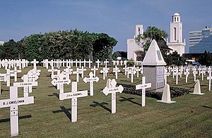
Menteng Pulo War Cemetery
Dutch war cemetery in Jakarta, Indonesia
Distance: Approx. 1343 meters
Latitude and longitude: -6.2223345,106.8394822
Dutch War Cemetery Menteng Pulo (Indonesian: Makam Kehormatan Belanda di Menteng Pulo), also Dutch Field of Honor Menteng Pulo (Dutch: Nederlands Ereveld Menteng Pulo), is a war cemetery at Jl. Menteng Pulo RT. 3 RW. 12, Menteng Dalam, Tebet, Jakarta in Indonesia. It is one of two Dutch war cemeteries in Jakarta, the other one is Dutch War Cemetery Ancol at Ancol.

Setiabudi LRT Station
Distance: Approx. 1610 meters
Latitude and longitude: -6.209277,106.830211
Setiabudi LRT Station is a light rail station located on Jalan H.R. Rasuna Said, Guntur, Setiabudi, South Jakarta. The station, which is located at an altitude of +22.55 meters, serves the Cibubur and Bekasi lines of the Jabodebek LRT system. Despite sharing the same name, it is not an interchange and is not to be confused with the MRT Jakarta station at Setiabudi Astra station, and is in fact located 600 meters apart from each other.
Weather in this IP's area
few clouds
32 Celsius
35 Celsius
30 Celsius
32 Celsius
1009 hPa
54 %
1009 hPa
1008 hPa
7000 meters
7.72 m/s
70 degree
20 %
05:49:36
17:51:23