Country:
 USA
USARegion:
City:
Latitude and Longitude:
Time Zone:
Postal Code:
IP information under different IP Channel
ip-api
Country
Region
City
ASN
Time Zone
ISP
Blacklist
Proxy
Latitude
Longitude
Postal
Route
IPinfo
Country
Region
City
ASN
Time Zone
ISP
Blacklist
Proxy
Latitude
Longitude
Postal
Route
MaxMind
Country
Region
City
ASN
Time Zone
ISP
Blacklist
Proxy
Latitude
Longitude
Postal
Route
Luminati
Country
USRegion
wa
City
seattle
ASN
Time Zone
America/Los_Angeles
ISP
SG.GS
Latitude
Longitude
Postal
db-ip
Country
Region
City
ASN
Time Zone
ISP
Blacklist
Proxy
Latitude
Longitude
Postal
Route
ipdata
Country
Region
City
ASN
Time Zone
ISP
Blacklist
Proxy
Latitude
Longitude
Postal
Route
Popular places and events near this IP address

Alaskan Way Seawall
Seawall in Seattle, Washington
Distance: Approx. 204 meters
Latitude and longitude: 47.60444444,-122.33916667
The Alaskan Way Seawall is a seawall which runs for approximately 7,166 feet (2,184 m) along the Elliott Bay waterfront southwest of downtown Seattle from Bay Street to S. Washington Street. The seawall is being rebuilt in the 2010s as part of a waterfront redevelopment megaproject estimated to cost over $1 billion.
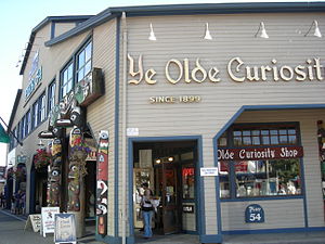
Ye Olde Curiosity Shop
Store on the Central Waterfront of Seattle, Washington, United States
Distance: Approx. 151 meters
Latitude and longitude: 47.6043,-122.3399
Ye Olde Curiosity Shop is a store founded in 1899, on the Central Waterfront of Seattle, Washington, United States. It is currently located on Pier 54. Best known today as a souvenir shop and museum, it also has aspects of a dime museum, and is an important supplier of Northwest Coast art to museums.
Seattle Marine Aquarium
Aquarium in Washington, USA
Distance: Approx. 154 meters
Latitude and longitude: 47.6041774,-122.3397052
The Seattle Marine Aquarium (originally known as the Seattle Public Aquarium) was a privately owned aquarium that was opened in 1962 and closed in 1977, and was located on Pier 56 on the Elliott Bay waterfront in Seattle, Washington, USA.

Colman Dock
Ferry terminal in Seattle, Washington, U.S.
Distance: Approx. 230 meters
Latitude and longitude: 47.602722,-122.338512
Colman Dock, also called Pier 52, is the primary ferry terminal in Seattle, Washington, United States. The original pier is no longer in existence, but the terminal, now used by the Washington State Ferries system, is still called "Colman Dock". The terminal serves two routes to Bainbridge Island and Bremerton and has an adjacent passenger-only facility at Pier 50 for King County Water Taxi and Kitsap Fast Ferries routes.

Grand Trunk Pacific dock
Wharf in Seattle (1910–1964)
Distance: Approx. 190 meters
Latitude and longitude: 47.60361111,-122.33888889
The Grand Trunk Pacific dock was a shipping pier in Seattle, Washington. The original pier was built in 1910 and was destroyed in a fire in 1914. The pier was then rebuilt and continued in existence until 1964, when it was dismantled.

Pier 54, Seattle
Distance: Approx. 170 meters
Latitude and longitude: 47.60416667,-122.33944444
Pier 54 is a tourist pier in Seattle, Washington. Previously an active shipping pier and warehouse, Pier 54 was originally known as Pier 3 until it was renumbered during World War II. This pier was also known as Galbraith dock and the Galbraith Bacon dock. Because of the large number of smaller local steamships, generally built of wood, that used the pier up until the 1930s, the pier was also known as the “Mosquito Fleet dock”.

Pier 55, Seattle
Distance: Approx. 207 meters
Latitude and longitude: 47.605,-122.34
Pier 55 is a pier in Seattle, Washington. Pier 55 was originally known as Pier 4 until it was renumbered during World War Two.

Seattle Great Wheel
Ferris wheel in Seattle, Washington, U.S.
Distance: Approx. 312 meters
Latitude and longitude: 47.6061,-122.3425
The Seattle Great Wheel is a 53-meter tall giant Ferris wheel at Pier 57 on Elliott Bay in Seattle, Washington, United States. At an overall height of 175 feet (53.3 m), it was the tallest Ferris wheel on the West Coast of the United States when it opened in June 2012.

Pier 57 (Seattle)
Distance: Approx. 303 meters
Latitude and longitude: 47.6061,-122.3419
Pier 57 (originally Pier 6) is located in Seattle, Washington near the foot of University Street. Currently under private ownership, the pier is now a tourist attraction with gift shops and restaurants, and houses the Seattle Great Wheel.

Agen Warehouse
United States historic place
Distance: Approx. 319 meters
Latitude and longitude: 47.60583333,-122.33916667
The Agen Warehouse, also known as the 1201 Western Building is an historic former warehouse building located at 1201 Western Avenue in Seattle, Washington. Originally constructed in 1910 by John B. Agen (1856–1920), widely considered the father of the dairy industry in the Northwest, for his wholesale dairy commission business, it was designed by the partnership of John Graham, Sr. and David J. Myers with later additions designed by Graham alone.

Ivar Feeding the Gulls
Sculpture in Seattle, Washington, U.S.
Distance: Approx. 204 meters
Latitude and longitude: 47.603839,-122.338763
Ivar Feeding the Gulls is an outdoor 1988 bronze and aluminum sculpture by Richard Beyer, installed outside Ivar's Fish Bar by Pier 54, along Seattle's Waterfront in the U.S. state of Washington. The statue depicts Ivar Haglund, who founded the restaurant, feeding French fries to gulls. It was donated by a group of friends; their names are inscribed on the back of the chair.

Fisherman's Restaurant and Bar
Seafood restaurant in Seattle, Washington, U.S.
Distance: Approx. 303 meters
Latitude and longitude: 47.60611111,-122.34111111
Fisherman's Restaurant and Bar is a seafood restaurant in Seattle, in the U.S. state of Washington.
Weather in this IP's area
clear sky
17 Celsius
17 Celsius
16 Celsius
19 Celsius
1011 hPa
87 %
1011 hPa
1011 hPa
10000 meters
2.57 m/s
160 degree
06:38:15
19:35:46