124.41.213.15 - IP Lookup: Free IP Address Lookup, Postal Code Lookup, IP Location Lookup, IP ASN, Public IP
Country:
Region:
City:
Location:
Time Zone:
Postal Code:
ISP:
ASN:
language:
User-Agent:
Proxy IP:
Blacklist:
IP information under different IP Channel
ip-api
Country
Region
City
ASN
Time Zone
ISP
Blacklist
Proxy
Latitude
Longitude
Postal
Route
db-ip
Country
Region
City
ASN
Time Zone
ISP
Blacklist
Proxy
Latitude
Longitude
Postal
Route
IPinfo
Country
Region
City
ASN
Time Zone
ISP
Blacklist
Proxy
Latitude
Longitude
Postal
Route
IP2Location
124.41.213.15Country
Region
lumbini
City
siddharthanagar
Time Zone
Asia/Kathmandu
ISP
Language
User-Agent
Latitude
Longitude
Postal
ipdata
Country
Region
City
ASN
Time Zone
ISP
Blacklist
Proxy
Latitude
Longitude
Postal
Route
Popular places and events near this IP address

Rupandehi District
District in Lumbini Province, Nepal
Distance: Approx. 0 meters
Latitude and longitude: 27.5,83.45
Rupandehi District (Nepali: रुपन्देही जिल्ला; pronounced [ɾu.pʌn.de.i; -e.ɦi] ), a part of Lumbini Province, is one of the seventy-seven districts of Nepal and covers an area of 1,360 km2 (530 sq mi). The district headquarter is Bhairahawa. As per the national census 2011, the population of Rupandehi was 880,196.

Siddharthanagar
Municipality in Lumbini, Nepal
Distance: Approx. 0 meters
Latitude and longitude: 27.5,83.45
Siddharthanagar (Nepali: सिद्धार्थनगर), formerly and colloquially still called Bhairahawa (Nepali: भैरहवा), is a municipality and the administrative headquarter of Rupandehi District in Lumbini Province of Nepal, 265 km (165 mi) west of Nepal's capital Kathmandu. It is the closest city to Lumbini, the birthplace of Gautama Buddha, which is located 25 km (16 mi) to the west. The city borders the Indian city of Sonauli in Maharajganj district of Uttar Pradesh.
Bagaha, Nepal
Village development committee in Lumbini Province, Nepal
Distance: Approx. 4104 meters
Latitude and longitude: 27.49,83.49
Bagaha is a village development committee in Rupandehi District in Lumbini Province of southern Nepal. At the time of the 1991 Nepal census it had a population of 3770 people living in 559 individual households.
Basantapur, Rupandehi
Village development committee in Lumbini Province, Nepal
Distance: Approx. 4103 meters
Latitude and longitude: 27.51,83.49
Basantapur, Rupandehi is a village development committee in Rupandehi District in Lumbini Province of southern Nepal. At the time of the 1991 Nepal census it had a population of 4472 people living in 664 individual households.
Chilhiya
Village development committee in Lumbini Province, Nepal
Distance: Approx. 5566 meters
Latitude and longitude: 27.55,83.45
Chilhiya is a village development committee in Rupandehi District in Lumbini Province of southern Nepal. At the time of the 1991 Nepal census it had a population of 3895 people living in 635 individual households.
Hati Bangai
Village development committee in Lumbini Province, Nepal
Distance: Approx. 3880 meters
Latitude and longitude: 27.53,83.43
Hati Bangai is a village development committee in Rupandehi District in Lumbini Province of southern Nepal. At the time of the 1991 Nepal census it had a population of 3278 people living in 521 individual households. It is a developing city.
Mainahiya
Village development committee in Lumbini Province, Nepal
Distance: Approx. 6648 meters
Latitude and longitude: 27.54,83.4
Mainahiya is a village development committee in Rupandehi District in Lumbini Province of southern Nepal. At the time of the 1991 Nepal census it had a population of 6708.
Maryadpur, Rupandehi
Village development committee in Lumbini Province, Nepal
Distance: Approx. 6802 meters
Latitude and longitude: 27.47,83.39
Maryadpur is a village development committee in Rupandehi District in Lumbini Province of southern Nepal. At the time of the 1991 Nepal census it had a population of 4334 people living in 649 individual households.
Padsari
Village development committee in Lumbini Province, Nepal
Distance: Approx. 4561 meters
Latitude and longitude: 27.54,83.46
Padsari is a village development committee in Rupandehi District in Lumbini Province of southern Nepal. At the time of the 1991 Nepal census it had a population of 5049 people living in 864 individual households.
Pajarkatli
Village development committee in Lumbini Province, Nepal
Distance: Approx. 6840 meters
Latitude and longitude: 27.48333333,83.51666667
Pajarkatti is a village development committee in Rupandehi District in Lumbini Province of southern Nepal. At the time of the 1991 Nepal census it had a population of 4372 people living in 633 individual households.

Sonauli
Town in Uttar Pradesh, India
Distance: Approx. 3474 meters
Latitude and longitude: 27.473806,83.46913
Sonauli is a town, near city of Maharajganj in Maharajganj district in Uttar Pradesh, India. It located on the Indo-Nepal Border and is a well-known and most famous transit point between India and Nepal. Sonauli is around 75 km from district headquarter Mahrajganj, Uttar Pradesh.

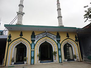
Jama Masjid Rahmaniya, Bhairahawa
Mosque in Rupandehi, Siddharthanagar, Nepal
Distance: Approx. 0 meters
Latitude and longitude: 27.5,83.45
The Jama Masjid Rahmaniya is the oldest mosque in Rupandehi, Bhairahawa, Nepal. Completed in 1950 AD (2007 BS). It is built in a traditional Islamic style, with a large central dome and four minarets, and is adorned with intricate designs and calligraphy on the interior.
Weather in this IP's area
clear sky
23 Celsius
22 Celsius
23 Celsius
23 Celsius
1016 hPa
37 %
1016 hPa
1002 hPa
10000 meters
1.98 m/s
1.77 m/s
243 degree