Country:
Region:
City:
Latitude and Longitude:
Time Zone:
Postal Code:
IP information under different IP Channel
ip-api
Country
Region
City
ASN
Time Zone
ISP
Blacklist
Proxy
Latitude
Longitude
Postal
Route
Luminati
Country
ASN
Time Zone
Asia/Hong_Kong
ISP
Hutchison Telephone Company Limited
Latitude
Longitude
Postal
IPinfo
Country
Region
City
ASN
Time Zone
ISP
Blacklist
Proxy
Latitude
Longitude
Postal
Route
db-ip
Country
Region
City
ASN
Time Zone
ISP
Blacklist
Proxy
Latitude
Longitude
Postal
Route
ipdata
Country
Region
City
ASN
Time Zone
ISP
Blacklist
Proxy
Latitude
Longitude
Postal
Route
Popular places and events near this IP address

Yau Ma Tei
Area in Kowloon Peninsula, Hong Kong
Distance: Approx. 180 meters
Latitude and longitude: 22.31301,114.17053
Yau Ma Tei is an area in the Yau Tsim Mong District in the south of the Kowloon Peninsula in Hong Kong.

Yau Ma Tei station
MTR interchange station in Kowloon, Hong Kong
Distance: Approx. 202 meters
Latitude and longitude: 22.3129,114.1707
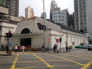
Yau Ma Tei, formerly named Waterloo after Waterloo Road, is an MTR station located in Yau Ma Tei, Kowloon. It lays straightly like a long box under thoroughfare Nathan Road, ending north under Pitt Street and south near Man Ming Lane. It is served by the Kwun Tong line and the Tsuen Wan line.
Yau Ma Tei Theatre
Historic building in Kowloon, Hong Kong
Distance: Approx. 153 meters
Latitude and longitude: 22.312436,114.169187
Yau Ma Tei Theatre (sometimes transliterated as "Yaumati Theatre"), once the largest theatre in Kowloon, is located at the junction of Waterloo Road and Reclamation Street, in Yau Ma Tei, Hong Kong. It is classified as "Grade II Historic Building" It is the only remaining pre-World War II theatre in Kowloon. It was recently converted into a venue for Cantonese opera.
Reclamation Street
Street in Kowloon, Hong Kong
Distance: Approx. 308 meters
Latitude and longitude: 22.31105,114.1693
Reclamation Street is a street stretching from Jordan to Mong Kok, Kowloon, Hong Kong. As its name suggests, it was built on the reclaimed western shore of the Kowloon Peninsula.
Broadway Cinematheque
Cinema in Yau Ma Tei, Hong Kong
Distance: Approx. 345 meters
Latitude and longitude: 22.310701,114.168924
Broadway Cinematheque (Chinese: 百老匯電影中心) is a cinema in Yau Ma Tei, Hong Kong, run by Broadway Circuit. Located in Prosperous Garden, a public housing estate, the cinema screens a wider spectrum of films including independent and art films than other cinemas in Hong Kong. The cinema hosts four houses with 476 seats (115 normal seats + 4 wheelchair seats per house).

Soy Street
Distance: Approx. 313 meters
Latitude and longitude: 22.316096,114.167243
Soy Street (Chinese: 豉油街) is a street in Mong Kok, Kowloon, Hong Kong. It starts from Tak Cheong Street in the west, crosses several major streets including Nathan Road, and ends near Waterloo Road. The section between Nathan Road and Sai Yeung Choi Street South is for pedestrians only.

Yau Ma Tei Fruit Market
Marketplace in Kowloon, Hong Kong
Distance: Approx. 196 meters
Latitude and longitude: 22.3122,114.1682
The Yau Ma Tei Fruit Market, officially Yau Ma Tei Wholesale Fruit Market, also simply known as the Fruit Market, is a wholesale fruit market in Yau Ma Tei, Kowloon, Hong Kong.

Tung Wah Museum
Distance: Approx. 323 meters
Latitude and longitude: 22.3149,114.1719
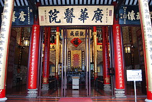
Tung Wah Museum is a museum housed in the former Main Hall Building of Kwong Wah Hospital, located at 25 Waterloo Road, Kowloon, Hong Kong. Only this building was preserved when Kwong Wah Hospital was re-developed in 1958–1963. This building was built in 1911; it was classified as a Grade I historic building and in 2010, it was declared as a monument in 2010.

Engineer's Office of the Former Pumping Station
Pumping station in Hong Kong
Distance: Approx. 175 meters
Latitude and longitude: 22.31234,114.16964
The Engineer's Office of the Former Pumping Station, Water Supplies Department, sometimes called "The Red Brick House", is located at No. 344 Shanghai Street, in Yau Ma Tei, Hong Kong. It has been classified as a Grade I historical building since 2000 by the Antiquities Advisory Board in view of its historical and architectural merit.

ELCHK Lutheran Secondary School
Secondary school in Hong Kong
Distance: Approx. 327 meters
Latitude and longitude: 22.31319,114.17211
ELCHK Lutheran Secondary School (LSS) (Chinese: 基督教香港信義會信義中學) is a Lutheran aided mixed-sex secondary school in King's Park, Yau Tsim Mong District, Hong Kong established in 1958. The school moved to its current location in 1964, which is near Yau Ma Tei station.

Ferry Street, Hong Kong
Throughfare in Yau Ma Tei, Hong Kong
Distance: Approx. 300 meters
Latitude and longitude: 22.31175247,114.16709963
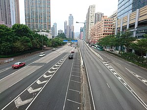
Ferry Street (Chinese: 渡船街) is a throughfare running north–south through Mong Kok, Yau Ma Tei, and Jordan in Hong Kong. It is a major road housing the West Kowloon Corridor above it, making it one of the busiest roads in Kowloon. Before the start of land reclamation in the 1990s, this road marked the coast of West Kowloon, and most piers were built on this road, hence the name.

Pitt Street, Hong Kong
Street in Hong Kong
Distance: Approx. 112 meters
Latitude and longitude: 22.31383,114.17009
Pitt Street, named after William Pitt the Younger, prime minister of the United Kingdom, and before Acts of Union 1800, of Great Britain, is a street in one of the busiest sections in Yau Ma Tei of Hong Kong, hosting several prominent sites including Kwong Wah Hospital and the headquarters of Chinese YMCA of Hong Kong, spanning across three thoroughfares, namely Ferry Street in the west, Waterloo Road in the east and Nathan Road in the middle, which connecting north and south of Kowloon Peninsula. While said to be in Yau Ma Tei, it could be in Mong Kok or Mong Kok Tsui, depending on context. Its name in Chinese character is 碧街, which the character 碧 /pik/, literally greenish jade, is a phonetic approximation of Pitt in Cantonese and 街 a literal translation of street.
Weather in this IP's area
broken clouds
24 Celsius
25 Celsius
23 Celsius
25 Celsius
1016 hPa
79 %
1016 hPa
1013 hPa
10000 meters
4.92 m/s
40 degree
61 %
06:37:46
17:39:31


