Country:
 Australia
Region:
City:
Latitude and Longitude:
Time Zone:
Postal Code:
IP information under different IP Channel
ip-api
Country
Region
City
ASN
Time Zone
ISP
Blacklist
Proxy
Latitude
Longitude
Postal
Route
IPinfo
Country
Region
City
ASN
Time Zone
ISP
Blacklist
Proxy
Latitude
Longitude
Postal
Route
MaxMind
Country
Region
City
ASN
Time Zone
ISP
Blacklist
Proxy
Latitude
Longitude
Postal
Route
Luminati
Country
AURegion
act
City
canberra
ASN
Time Zone
Australia/Sydney
ISP
Internode Pty Ltd
Latitude
Longitude
Postal
db-ip
Country
Region
City
ASN
Time Zone
ISP
Blacklist
Proxy
Latitude
Longitude
Postal
Route
ipdata
Country
Region
City
ASN
Time Zone
ISP
Blacklist
Proxy
Latitude
Longitude
Postal
Route
Popular places and events near this IP address

Mount Ainslie
Hill in Canberra, Australia
Distance: Approx. 2434 meters
Latitude and longitude: -35.27,149.15833333
Mount Ainslie is a hill with an elevation of 843 metres (2,766 ft) AHD that is located in the northeastern suburbs of Canberra, in the Australian Capital Territory, Australia. Mount Ainslie lies within part of the Canberra Nature Park.

Dickson, Australian Capital Territory
Suburb of Canberra, Australia
Distance: Approx. 2780 meters
Latitude and longitude: -35.2525,149.13972222
Dickson is a suburb in the Inner North of Canberra, Australia. It is named after Sir James R. Dickson (1832–1901) who was a Queensland advocate of Australian Federation and one of the founders of the Australian Constitution. There is no specific theme for street names.

Mount Majura
Mountain in Canberra, Australia
Distance: Approx. 1717 meters
Latitude and longitude: -35.2375,149.18055556
Mount Majura is a small mountain with an elevation of 890 metres (2,920 ft) AHD that is located in the northern suburbs of Canberra in the Australian Capital Territory, Australia. Mount Majura lies close to the more prominent Mount Ainslie and is the highest point within the urban boundaries of Canberra. Mount Majura is contained within part of the Canberra Nature Park.

Downer, Australian Capital Territory
A suburb of Canberra, Australia
Distance: Approx. 2394 meters
Latitude and longitude: -35.24416667,149.145
Downer is a suburb of Canberra, Australia, in the city's inner north. The suburb is bounded by Northbourne Avenue, Antill Street and Philip Avenue. The suburb was gazetted in 1960 and named after Sir John Downer (1844–1915) Premier of South Australia and a member of the first Australian Senate in 1901.

Ainslie, Australian Capital Territory
Suburb of Canberra, Australia
Distance: Approx. 2738 meters
Latitude and longitude: -35.26277778,149.14416667
Ainslie is a suburb of Canberra, Australia in the North Canberra district. The suburb is bounded by Limestone Avenue and Majura Avenue to the west and north, Phillip Avenue to the north-east, Mount Ainslie to the east and Quick Street to the south. Ainslie is within walking distance of the City, the nature trails of Mount Ainslie, the Australian War Memorial and the many restaurants of Dickson.

Watson, Australian Capital Territory
Suburb of Canberra, Australia
Distance: Approx. 2039 meters
Latitude and longitude: -35.23833333,149.15333333
Watson is a suburb of Canberra, Australia in the North Canberra district. Watson is named after the third Prime Minister of Australia, John Christian Watson. The suburb name was gazetted on 7 April 1960.

Dickson College
College/secondary school in Dickson, ACT, Australia
Distance: Approx. 1571 meters
Latitude and longitude: -35.249,149.153
Dickson College is a public two-year secondary college located in the Canberra suburb of Dickson, Australian Capital Territory. It was established in 1976 on the former Dickson High School campus when it closed. It was set to close after being announced as the sole college in Canberra to be eliminated for the Towards 2020 plan, but was spared when the final decision was made.

Hackett, Australian Capital Territory
Suburb of Canberra, Australia
Distance: Approx. 723 meters
Latitude and longitude: -35.24805556,149.16277778
Hackett () is an inner north suburb of Canberra, the capital city of Australia. Located approximately 4.5 km (2.8 mi) north-east of the central business district, Hackett is adjacent to Watson, Dickson and Ainslie. It is bounded by Antill Street and Philip Avenue, and the Mount Majura Nature Reserve to the east.

Academy of Interactive Entertainment
Australian videos game and animation school
Distance: Approx. 2127 meters
Latitude and longitude: -35.2409043,149.1499011
The Academy of Interactive Entertainment (AIE) is an Australian video games and computer animation school. Founded in 1996, it was one of the world's first institutions to offer qualifications in these industries. The AIE provides courses covering CGI, animation, video game asset creation and games programming.

St Margaret's Uniting Church, Hackett
Church in Australian Capital Territory, Australia
Distance: Approx. 1410 meters
Latitude and longitude: -35.2475,149.1551
St Margaret's Uniting Church is a Uniting church in Hackett, Australian Capital Territory, Australia. The church shares a spire with Holy Cross Anglican congregation is a major landmark in North Canberra, at the intersection of the four suburbs of Watson, Dickson, Downer and Hackett.

Exhibition Park in Canberra
Distance: Approx. 2928 meters
Latitude and longitude: -35.233071,149.145968
Exhibition Park in Canberra (EPIC) is a 70 hectare showground and multi-building venue for exhibitions, conferences, and events located in the suburb of Lyneham (though commonly listed in the adjacent Mitchell) in Canberra, Australia.
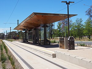
Phillip Avenue light rail station
Distance: Approx. 2890 meters
Latitude and longitude: -35.23583333,149.14388889
Phillip Avenue is a light rail station in Australia on the Canberra Metro R1 Civic to Gungahlin line, located on the Federal Highway at the intersection of Phillip Avenue. The station primarily serves the suburb of Watson although it is close to Exhibition Park in Canberra and a few businesses in the northern part of Lyneham, providing an alternative to the EPIC and Racecourse station during major events. Bicycle racks are provided for commuters adjacent to the station, but there is no dedicated parking or "kiss and ride" bays available.
Weather in this IP's area
clear sky
1 Celsius
1 Celsius
-1 Celsius
3 Celsius
1028 hPa
89 %
1028 hPa
948 hPa
10000 meters
0.51 m/s
40 degree
5 %
06:00:15
17:55:40